Property Record
20315 Leitersburg Pike, Hagerstown, MD 21742

NEARBY LISTINGS FOR SALE OR LEASE
-
-
View all Hagerstown listings for sale on LoopNet.com
Property Detail
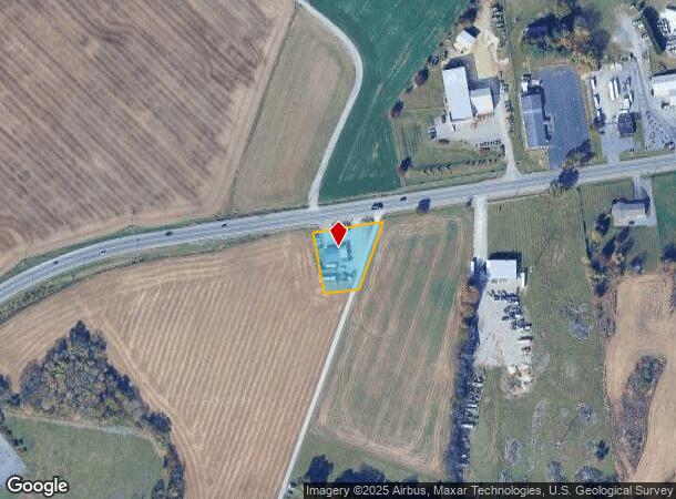
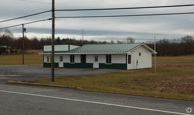
20315 Leitersburg Pike
09-008527
LOT 178X150 .47 A 20315 LEITERSBURG PIKE
Officebuilding
Washington
X
Maryland
24043C0141D
0.47 AC
2024
Washington County
2025
Washington, DC
011202
Hagerstown-Martinsburg, MD-WV
1,680 SF
DEMOGRAPHICS near 20315 Leitersburg Pike
1 Mile
3 Mile
5 Mile
2024 Total Population
395
13,118
70,841
2029 Population
400
13,257
71,619
Pop Growth 2024-2029
+ 1.27%
+ 1.06%
+ 1.10%
Average Age
41
42
40
2024 Total Households
144
5,065
28,229
HH Growth 2024-2029
+ 0.69%
+ 1.20%
+ 1.16%
Median Household Inc
$83,035
$79,238
$56,342
Avg Household Size
2.70
2.60
2.40
2024 Avg HH Vehicles
2.00
2.00
2.00
Median Home Value
$318,000
$309,609
$230,552
Median Year Built
1985
1982
1971
Nearby Places
Map Layers
Map Styles
 Street
 Aerial
- Restaurants
- Banks
- Shops
- Fitness
- Groceries
PUBLIC TRANSPORTATION
AIRPORT
Hagerstown Regional/Richard A Henson Field
DRIVE
WALK
Distance
Hagerstown Regional/Richard A Henson Field
11 min
5.1 mi
Freight Ports
Port of Baltimore
DRIVE
WALK
Distance
Port of Baltimore
96 min
79.2 mi
Nearby Properties
Address
Land Use
TOTAL SIZE
Lot Size
Zoning
Address
Land Use
TOTAL SIZE
Lot Size
Zoning
216 SF
52.93 AC
RH
Address
Land Use
TOTAL SIZE
Lot Size
Zoning
71,928 SF
24.77 AC
RMOD
Address
Land Use
TOTAL SIZE
Lot Size
Zoning
23,086 SF
19.36 AC
CR
Address
Land Use
TOTAL SIZE
Lot Size
Zoning
3,159 SF
14.99 AC
CR
Address
Land Use
TOTAL SIZE
Lot Size
Zoning
84,796 SF
8.81 AC
PB
Address
Land Use
TOTAL SIZE
Lot Size
Zoning
78,042 SF
11 AC
RB-E
Address
Land Use
TOTAL SIZE
Lot Size
Zoning
1,152 SF
27.83 AC
U
Address
Land Use
TOTAL SIZE
Lot Size
Zoning
7,273 SF
146.87 AC
AR
Address
Land Use
TOTAL SIZE
Lot Size
Zoning
139,403 SF
15.06 AC
CR
Address
Land Use
TOTAL SIZE
Lot Size
Zoning
287,625 SF
19.69 AC
IG
Address
Land Use
TOTAL SIZE
Lot Size
Zoning
20,312 SF
17.59 AC
U
Address
Land Use
TOTAL SIZE
Lot Size
Zoning
6,077 SF
8.82 AC
U
Address
Land Use
TOTAL SIZE
Lot Size
Zoning
47,923 SF
10.25 AC
RS
Address
Land Use
TOTAL SIZE
Lot Size
Zoning
7.11 AC
PB
Address
Land Use
TOTAL SIZE
Lot Size
Zoning
35,460 SF
8.32 AC
RT PU
Address
Land Use
TOTAL SIZE
Lot Size
Zoning
35,424 SF
3 AC
CG
Address
Land Use
TOTAL SIZE
Lot Size
Zoning
40,788 SF
9.69 AC
RMOD
Address
Land Use
TOTAL SIZE
Lot Size
Zoning
6.42 AC
RS
Address
Land Use
TOTAL SIZE
Lot Size
Zoning
16,660 SF
3.08 AC
CG
Address
Land Use
TOTAL SIZE
Lot Size
Zoning
170 SF
112.52 AC
RU
Address
Land Use
TOTAL SIZE
Lot Size
Zoning
62,480 SF
2.55 AC
BL
Address
Land Use
TOTAL SIZE
Lot Size
Zoning
49,700 SF
8.68 AC
RMOD
Address
Land Use
TOTAL SIZE
Lot Size
Zoning
6,134 SF
2.59 AC
CR
Address
Land Use
TOTAL SIZE
Lot Size
Zoning
5,310 SF
3.67 AC
RMOD
Address
Land Use
TOTAL SIZE
Lot Size
Zoning
18.20 AC
BG
Address
Land Use
TOTAL SIZE
Lot Size
Zoning
16,337 SF
1.10 AC
PB
Address
Land Use
TOTAL SIZE
Lot Size
Zoning
28,578 SF
2.07 AC
BL
Address
Land Use
TOTAL SIZE
Lot Size
Zoning
13,077 SF
1.24 AC
BL
Address
Land Use
TOTAL SIZE
Lot Size
Zoning
9,621 SF
2.94 AC
BL
Address
Land Use
TOTAL SIZE
Lot Size
Zoning
57,162 SF
4 AC
RH
The World's #1 Commercial Real Estate Marketplace
Connect with us
© 2025 CoStar Group
The information above has been obtained from sources believed reliable. While we do not doubt its accuracy we have not verified it and make no guarantee, warranty or representation about it. It is your responsibility to independently confirm its accuracy and completeness. Any projections, opinions, assumptions, or estimates used are for example only and do not represent the current or future performance of the property. The value of this transaction to you depends on tax and other factors which should be evaluated by your tax, financial, and legal advisors. You and your advisors should conduct a careful, independent investigation of the property to determine to your satisfaction the suitability of the property for your needs.