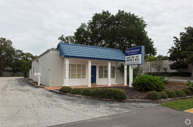
Property Record
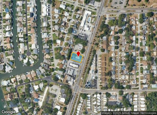
2032 Bayshore Blvd, Dunedin, FL 34698

NEARBY LISTINGS FOR SALE OR LEASE
Property Detail
2032 Bayshore Blvd
Tampa-St. Petersburg-Clearwater, FL
Harbor View Villas 2Nd Add
22-28-15-36612-000-0100
HARBOR VIEW VILLAS 2ND ADD LOT 10 & SLY 15FT OF LOT 9 & NLY 35.56FT OF LOT 11
Officebuilding
Pinellas
AE
Florida
12103C0066H
10
2024
0.34 AC
2025
North Pinellas
027106
Tampa/St Petersburg
1,612 SF
DEMOGRAPHICS near 2032 Bayshore Blvd
1 Mile
3 Mile
5 Mile
2024 Total Population
6,504
57,514
161,733
2029 Population
6,586
57,629
162,008
Pop Growth 2024-2029
+ 1.26%
+ 0.20%
+ 0.17%
Average Age
54
50
49
2024 Total Households
3,255
27,691
74,748
HH Growth 2024-2029
+ 1.29%
+ 0.11%
+ 0.10%
Median Household Inc
$67,881
$59,986
$60,142
Avg Household Size
2.00
2.00
2.10
2024 Avg HH Vehicles
2.00
2.00
2.00
Median Home Value
$335,105
$313,318
$295,556
Median Year Built
1972
1977
1979
Nearby Places
Map Layers
Map Styles
 Street
 Aerial
- Restaurants
- Banks
- Shops
- Fitness
- Groceries
PUBLIC TRANSPORTATION
AIRPORT
St Pete-Clearwater International
DRIVE
WALK
Distance
St Pete-Clearwater International
34 min
19.2 mi
Tampa International
DRIVE
WALK
Distance
Tampa International
36 min
19.9 mi
Freight Ports
Port of Tampa Bay
DRIVE
WALK
Distance
Port of Tampa Bay
50 min
28.3 mi
Nearby Properties
Address
Land Use
TOTAL SIZE
Lot Size
Zoning
Address
Land Use
TOTAL SIZE
Lot Size
Zoning
675,202 SF
43.24 AC
Address
Land Use
TOTAL SIZE
Lot Size
Zoning
167,201 SF
63.11 AC
AE
Address
Land Use
TOTAL SIZE
Lot Size
Zoning
406,729 SF
29.79 AC
CP1
Address
Land Use
TOTAL SIZE
Lot Size
Zoning
412,099 SF
49.21 AC
Address
Land Use
TOTAL SIZE
Lot Size
Zoning
278,505 SF
38.67 AC
Address
Land Use
TOTAL SIZE
Lot Size
Zoning
362,238 SF
13.80 AC
Address
Land Use
TOTAL SIZE
Lot Size
Zoning
4,250 SF
235.09 AC
Address
Land Use
TOTAL SIZE
Lot Size
Zoning
117,024 SF
56.52 AC
Address
Land Use
TOTAL SIZE
Lot Size
Zoning
191,375 SF
13.58 AC
AE
Address
Land Use
TOTAL SIZE
Lot Size
Zoning
199,825 SF
22.75 AC
R2
Address
Land Use
TOTAL SIZE
Lot Size
Zoning
250,113 SF
39.50 AC
Address
Land Use
TOTAL SIZE
Lot Size
Zoning
196,808 SF
12.70 AC
Address
Land Use
TOTAL SIZE
Lot Size
Zoning
201,208 SF
2.16 AC
Address
Land Use
TOTAL SIZE
Lot Size
Zoning
173,160 SF
5.39 AC
Address
Land Use
TOTAL SIZE
Lot Size
Zoning
107,766 SF
25.15 AC
Address
Land Use
TOTAL SIZE
Lot Size
Zoning
158,400 SF
9.80 AC
Address
Land Use
TOTAL SIZE
Lot Size
Zoning
396,841 SF
9.73 AC
Address
Land Use
TOTAL SIZE
Lot Size
Zoning
415,593 SF
29.66 AC
Address
Land Use
TOTAL SIZE
Lot Size
Zoning
92,817 SF
6.42 AC
PC
Address
Land Use
TOTAL SIZE
Lot Size
Zoning
76,848 SF
12.60 AC
AE
Address
Land Use
TOTAL SIZE
Lot Size
Zoning
105,830 SF
10.84 AC
CP2
Address
Land Use
TOTAL SIZE
Lot Size
Zoning
94,971 SF
11.53 AC
RPD10
Address
Land Use
TOTAL SIZE
Lot Size
Zoning
85,666 SF
4.50 AC
R2
Address
Land Use
TOTAL SIZE
Lot Size
Zoning
90,791 SF
6.92 AC
Address
Land Use
TOTAL SIZE
Lot Size
Zoning
45,190 SF
12.04 AC
Address
Land Use
TOTAL SIZE
Lot Size
Zoning
97,776 SF
9.63 AC
Address
Land Use
TOTAL SIZE
Lot Size
Zoning
103,393 SF
17.68 AC
R4
Address
Land Use
TOTAL SIZE
Lot Size
Zoning
101,243 SF
5.36 AC
M1
Address
Land Use
TOTAL SIZE
Lot Size
Zoning
119,200 SF
7.75 AC
CP1
Address
Land Use
TOTAL SIZE
Lot Size
Zoning
75,044 SF
2.95 AC
The World's #1 Commercial Real Estate Marketplace
Connect with us
© 2025 CoStar Group
The information above has been obtained from sources believed reliable. While we do not doubt its accuracy we have not verified it and make no guarantee, warranty or representation about it. It is your responsibility to independently confirm its accuracy and completeness. Any projections, opinions, assumptions, or estimates used are for example only and do not represent the current or future performance of the property. The value of this transaction to you depends on tax and other factors which should be evaluated by your tax, financial, and legal advisors. You and your advisors should conduct a careful, independent investigation of the property to determine to your satisfaction the suitability of the property for your needs.