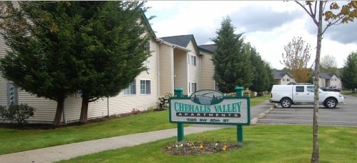
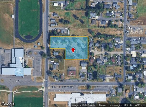
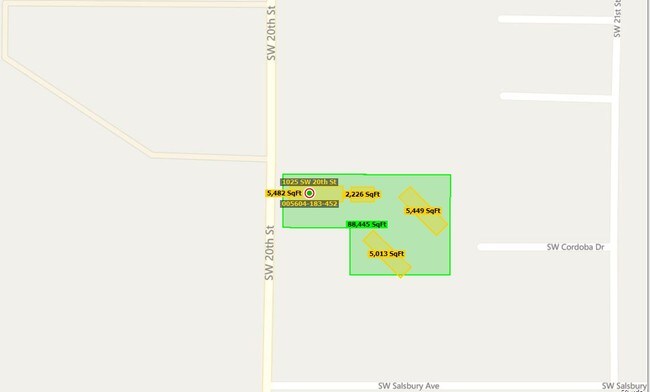
Property Record
2032 Sw 20Th St, Chehalis, WA 98532
NEARBY LISTINGS FOR SALE OR LEASE
Property Detail
2032 Sw 20Th St
Centralia, WA
Salsbury
005604-183-452
SECTION 04 TOWNSHIP 13N RANGE 02W PT N 2.50 AC LOT 6 SALSBURY TRS
Multifamilydwelling
Lewis
ARE
Washington
5301021364C
6
2024
2.03 AC
2025
Washington State Area
971000
Other Market Areas
13,324 SF
DEMOGRAPHICS near 2032 Sw 20Th St
1 Mile
3 Mile
5 Mile
2024 Total Population
4,137
13,000
25,073
2029 Population
4,645
14,542
27,997
Pop Growth 2024-2029
+ 12.28%
+ 11.86%
+ 11.66%
Average Age
39
39
40
2024 Total Households
1,623
4,982
9,430
HH Growth 2024-2029
+ 12.32%
+ 11.98%
+ 11.78%
Median Household Inc
$70,694
$68,839
$71,428
Avg Household Size
2.50
2.50
2.60
2024 Avg HH Vehicles
2.00
2.00
2.00
Median Home Value
$318,217
$330,024
$339,010
Median Year Built
1976
1975
1978
Nearby Places
Map Layers
Map Styles
 Street
 Aerial
- Restaurants
- Banks
- Shops
- Fitness
- Groceries
PUBLIC TRANSPORTATION
COMMUTER RAIL
Centralia Amtrak Station (Amtrak Cascades - Amtrak, Coast Starlight - Amtrak)
DRIVE
WALK
Distance
Centralia Amtrak Station (Amtrak Cascades - Amtrak, Coast Starlight - Amtrak)
13 min
6.3 mi
Freight Ports
Port of Long View, WA
DRIVE
WALK
Distance
Port of Long View, WA
53 min
40.5 mi
Nearby Properties
Address
Land Use
TOTAL SIZE
Lot Size
Zoning
Address
Land Use
TOTAL SIZE
Lot Size
Zoning
317,972 SF
47.34 AC
IL
Address
Land Use
TOTAL SIZE
Lot Size
Zoning
19,200 SF
3.12 AC
ILCG
Address
Land Use
TOTAL SIZE
Lot Size
Zoning
114,778 SF
42.22 AC
RUGA
Address
Land Use
TOTAL SIZE
Lot Size
Zoning
2,704 SF
8.28 AC
IL
Address
Land Use
TOTAL SIZE
Lot Size
Zoning
739,659 SF
37.76 AC
IL
Address
Land Use
TOTAL SIZE
Lot Size
Zoning
15,000 SF
66.30 AC
EPFI
Address
Land Use
TOTAL SIZE
Lot Size
Zoning
10,848 SF
2.08 AC
EPFG
Address
Land Use
TOTAL SIZE
Lot Size
Zoning
222,077 SF
Address
Land Use
TOTAL SIZE
Lot Size
Zoning
3,012 SF
11.23 AC
R4
Address
Land Use
TOTAL SIZE
Lot Size
Zoning
82,667 SF
Address
Land Use
TOTAL SIZE
Lot Size
Zoning
43,477 SF
8.64 AC
CG
Address
Land Use
TOTAL SIZE
Lot Size
Zoning
8,280 SF
7.50 AC
EPFS
Address
Land Use
TOTAL SIZE
Lot Size
Zoning
172,800 SF
13.97 AC
IL
Address
Land Use
TOTAL SIZE
Lot Size
Zoning
118,034 SF
5.90 AC
IL
Address
Land Use
TOTAL SIZE
Lot Size
Zoning
3,742 SF
21.83 AC
EPFU
Address
Land Use
TOTAL SIZE
Lot Size
Zoning
2,741 SF
20.47 AC
EPFS
Address
Land Use
TOTAL SIZE
Lot Size
Zoning
1,755 SF
10.34 AC
IL
Address
Land Use
TOTAL SIZE
Lot Size
Zoning
4,361 SF
5.41 AC
R2
Address
Land Use
TOTAL SIZE
Lot Size
Zoning
2,464 SF
1 AC
CG
Address
Land Use
TOTAL SIZE
Lot Size
Zoning
83,043 SF
6.76 AC
CG
Address
Land Use
TOTAL SIZE
Lot Size
Zoning
62,352 SF
17.32 AC
IL
Address
Land Use
TOTAL SIZE
Lot Size
Zoning
83,978 SF
6.63 AC
Address
Land Use
TOTAL SIZE
Lot Size
Zoning
93,000 SF
6.54 AC
IL
Address
Land Use
TOTAL SIZE
Lot Size
Zoning
31,418 SF
1.75 AC
CF
Address
Land Use
TOTAL SIZE
Lot Size
Zoning
4.32 AC
RUGA
Address
Land Use
TOTAL SIZE
Lot Size
Zoning
56,121 SF
4.05 AC
ILCG
Address
Land Use
TOTAL SIZE
Lot Size
Zoning
56.31 AC
IL
Address
Land Use
TOTAL SIZE
Lot Size
Zoning
22,974 SF
8.73 AC
CF
Address
Land Use
TOTAL SIZE
Lot Size
Zoning
304,473 SF
27.22 AC
CG
Address
Land Use
TOTAL SIZE
Lot Size
Zoning
1,056 SF
12.90 AC
EPFS
The World's #1 Commercial Real Estate Marketplace
Connect with us
© 2025 CoStar Group
The information above has been obtained from sources believed reliable. While we do not doubt its accuracy we have not verified it and make no guarantee, warranty or representation about it. It is your responsibility to independently confirm its accuracy and completeness. Any projections, opinions, assumptions, or estimates used are for example only and do not represent the current or future performance of the property. The value of this transaction to you depends on tax and other factors which should be evaluated by your tax, financial, and legal advisors. You and your advisors should conduct a careful, independent investigation of the property to determine to your satisfaction the suitability of the property for your needs.