Property Record
2032 Sylvester Dr, Moultrie, GA 31768
NEARBY LISTINGS FOR SALE OR LEASE
-
-
View all Moultrie listings for lease on LoopNet.com
Property Detail
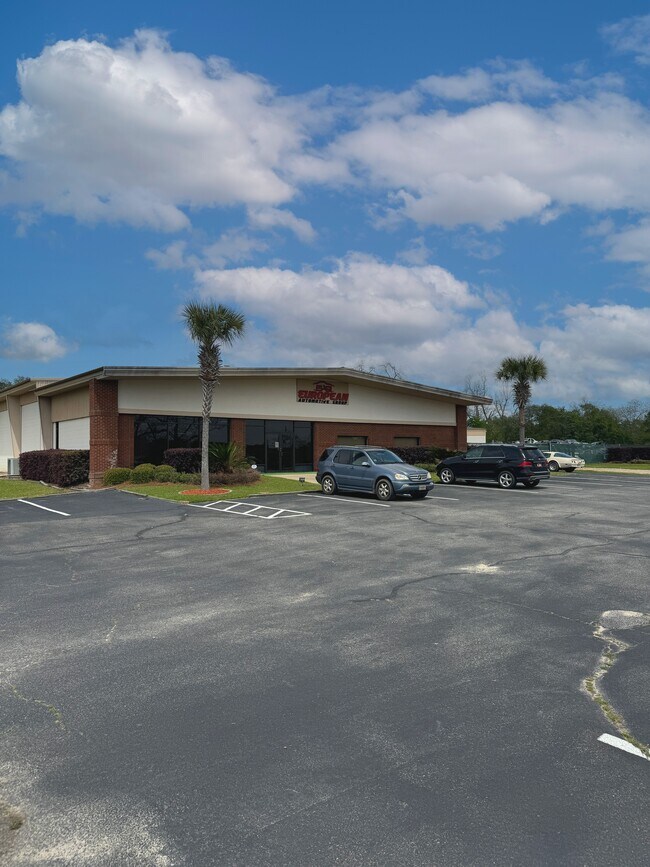
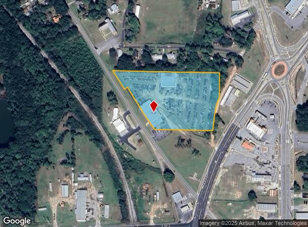
2032 Sylvester Dr
Moultrie, GA
Countryside
C037H-041
LOT 11 BLK A 210 15 SWIFT ST
Publicstorage
Colquitt
X
Georgia
13071C0183E
11
2024
4.91 AC
2024
Albany/Southwest
970302
Other Market Areas
10,611 SF
DEMOGRAPHICS near 2032 Sylvester Dr
1 Mile
3 Mile
5 Mile
2024 Total Population
2,796
16,322
24,748
2029 Population
2,839
16,476
24,813
Pop Growth 2024-2029
+ 1.54%
+ 0.94%
+ 0.26%
Average Age
36
38
39
2024 Total Households
1,032
6,218
9,386
HH Growth 2024-2029
+ 1.74%
+ 1.01%
+ 0.26%
Median Household Inc
$19,208
$33,844
$37,632
Avg Household Size
2.50
2.50
2.50
2024 Avg HH Vehicles
2.00
2.00
2.00
Median Home Value
$65,570
$86,305
$108,134
Median Year Built
1975
1974
1978
Nearby Places
Map Layers
Map Styles
 Street
 Aerial
- Restaurants
- Banks
- Shops
- Fitness
- Groceries
PUBLIC TRANSPORTATION
AIRPORT
Southwest Georgia Regional
DRIVE
WALK
Distance
Southwest Georgia Regional
54 min
39.6 mi
SALE & LEASE HISTORY
LISTING DATE
SALE/LEASE

Apr 23, 2024
For Lease
Nearby Properties
Address
Land Use
TOTAL SIZE
Lot Size
Zoning
Address
Land Use
TOTAL SIZE
Lot Size
Zoning
38,268 SF
2.07 AC
Address
Land Use
TOTAL SIZE
Lot Size
Zoning
73.72 AC
Address
Land Use
TOTAL SIZE
Lot Size
Zoning
24.25 AC
Address
Land Use
TOTAL SIZE
Lot Size
Zoning
21,678 SF
5.75 AC
Address
Land Use
TOTAL SIZE
Lot Size
Zoning
115.93 AC
COMMERCIAL
Address
Land Use
TOTAL SIZE
Lot Size
Zoning
21,866 SF
1.44 AC
Address
Land Use
TOTAL SIZE
Lot Size
Zoning
11.45 AC
Address
Land Use
TOTAL SIZE
Lot Size
Zoning
15.56 AC
Address
Land Use
TOTAL SIZE
Lot Size
Zoning
2,606 SF
15 AC
Address
Land Use
TOTAL SIZE
Lot Size
Zoning
17,574 SF
1.59 AC
Address
Land Use
TOTAL SIZE
Lot Size
Zoning
149,407 SF
15.29 AC
Address
Land Use
TOTAL SIZE
Lot Size
Zoning
27,504 SF
1.98 AC
Address
Land Use
TOTAL SIZE
Lot Size
Zoning
64,000 SF
13.98 AC
Address
Land Use
TOTAL SIZE
Lot Size
Zoning
18,096 SF
12.13 AC
Address
Land Use
TOTAL SIZE
Lot Size
Zoning
111,860 SF
13.50 AC
002
Address
Land Use
TOTAL SIZE
Lot Size
Zoning
105,612 SF
13.19 AC
002
Address
Land Use
TOTAL SIZE
Lot Size
Zoning
61,200 SF
9.50 AC
Address
Land Use
TOTAL SIZE
Lot Size
Zoning
189,470 SF
12.68 AC
Address
Land Use
TOTAL SIZE
Lot Size
Zoning
90,694 SF
19.17 AC
Address
Land Use
TOTAL SIZE
Lot Size
Zoning
27,217 SF
20.32 AC
Address
Land Use
TOTAL SIZE
Lot Size
Zoning
9,916 SF
6.24 AC
002
Address
Land Use
TOTAL SIZE
Lot Size
Zoning
21,574 SF
1.11 AC
Address
Land Use
TOTAL SIZE
Lot Size
Zoning
64,840 SF
9 AC
Address
Land Use
TOTAL SIZE
Lot Size
Zoning
2,614 SF
8.30 AC
Address
Land Use
TOTAL SIZE
Lot Size
Zoning
41,170 SF
1.63 AC
Address
Land Use
TOTAL SIZE
Lot Size
Zoning
37,295 SF
8.30 AC
Address
Land Use
TOTAL SIZE
Lot Size
Zoning
36,782 SF
300.68 AC
Address
Land Use
TOTAL SIZE
Lot Size
Zoning
38,848 SF
0.52 AC
Address
Land Use
TOTAL SIZE
Lot Size
Zoning
36,355 SF
7.08 AC
Address
Land Use
TOTAL SIZE
Lot Size
Zoning
9,396 SF
10.05 AC
The World's #1 Commercial Real Estate Marketplace
Connect with us
© 2025 CoStar Group
The information above has been obtained from sources believed reliable. While we do not doubt its accuracy we have not verified it and make no guarantee, warranty or representation about it. It is your responsibility to independently confirm its accuracy and completeness. Any projections, opinions, assumptions, or estimates used are for example only and do not represent the current or future performance of the property. The value of this transaction to you depends on tax and other factors which should be evaluated by your tax, financial, and legal advisors. You and your advisors should conduct a careful, independent investigation of the property to determine to your satisfaction the suitability of the property for your needs.