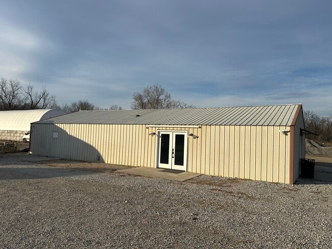
Property Record
20320 E Us 40 Hwy, Independence, MO 64015


Property Detail
20320 E Us 40 Hwy
34-600-03-07-01-0-00-000
SEC-28 TWP-49 RNG-31 PT SE 1/4 SW 1/4 DAF: BEG AT PT 920 S OF NE COR SD 1/4 1/4 SD PT ALSO INTERSEC WI N ROW LI HWY 40 TH WLY ALG SD ROW LI 91 MOL TH N 16 MOL TH WLY ALG SD N RO
Miscellaneous
JACKSON
AE The base floodplain where base flood elevations are provided. AE Zones are now used on new format FIRMs instead of A1-A30 Zones.
Missouri
2024
1 AC
2025
Blue Springs
014124
Kansas City
1,800 SF
Kansas City, MO-KS
NEARBY LISTINGS FOR SALE OR LEASE
DEMOGRAPHICS near 20320 E Us 40 Hwy
1 mile
3 mile
5 mile
2025 Total Population
3,611
42,452
118,942
2030 Population
3,654
42,589
118,963
Pop Growth 2025-2030
+ 1.19%
+ 0.32%
+ 0.02%
Average Age
47
42
42
2025 Total Households
1,626
17,307
47,689
HH Growth 2025-2030
+ 1.35%
+ 0.36%
0.00%
Median Household Inc
$60,726
$85,634
$79,133
Avg Household Size
2.10
2.40
2.40
2025 Avg HH Vehicles
2.00
2.00
2.00
Median Home Value
$230,229
$275,951
$251,254
Median Year Built
1995
1991
1981
Nearby Places
Map Layers
Map Styles
 Street
 Aerial
Transit
 Traffic
 Biking
Places
Listings with unknown addresses are not visible on the map
- Restaurants
- Banks
- Shops
- Fitness
- Groceries
PUBLIC TRANSPORTATION
COMMUTER RAIL
Drive
Walk
Distance
15 min
8.1 mi
AIRPORT
Kansas City International
Drive
Walk
Distance
Kansas City International
48 min
35.7 mi
SALE & LEASE HISTORY
LISTING DATE
SALE/LEASE

Mar 15, 2023
For Sale
Dec 20, 2024
For Sale
Nearby Properties
Address
Land Use
TOTAL SIZE
Lot Size
Zoning
Address
Land Use
TOTAL SIZE
Lot Size
Zoning
398,212 SF
73.80 AC
Address
Land Use
TOTAL SIZE
Lot Size
Zoning
158,369 SF
47.47 AC
Address
Land Use
TOTAL SIZE
Lot Size
Zoning
100,724 SF
1.65 AC
Address
Land Use
TOTAL SIZE
Lot Size
Zoning
448,225 SF
38.38 AC
Address
Land Use
TOTAL SIZE
Lot Size
Zoning
385,487 SF
5.61 AC
Address
Land Use
TOTAL SIZE
Lot Size
Zoning
338,731 SF
29.59 AC
Address
Land Use
TOTAL SIZE
Lot Size
Zoning
171,513 SF
18.37 AC
Address
Land Use
TOTAL SIZE
Lot Size
Zoning
96,348 SF
14.42 AC
Address
Land Use
TOTAL SIZE
Lot Size
Zoning
94,411 SF
4.99 AC
Address
Land Use
TOTAL SIZE
Lot Size
Zoning
39,638 SF
Address
Land Use
TOTAL SIZE
Lot Size
Zoning
120,053 SF
13.53 AC
Address
Land Use
TOTAL SIZE
Lot Size
Zoning
179,962 SF
16.02 AC
Address
Land Use
TOTAL SIZE
Lot Size
Zoning
31,674 SF
11.45 AC
Address
Land Use
TOTAL SIZE
Lot Size
Zoning
61,901 SF
15.11 AC
Address
Land Use
TOTAL SIZE
Lot Size
Zoning
36,396 SF
8.64 AC
Address
Land Use
TOTAL SIZE
Lot Size
Zoning
128,393 SF
27.30 AC
Address
Land Use
TOTAL SIZE
Lot Size
Zoning
75,028 SF
16.11 AC
Address
Land Use
TOTAL SIZE
Lot Size
Zoning
129,570 SF
18.40 AC
Address
Land Use
TOTAL SIZE
Lot Size
Zoning
67,820 SF
11.94 AC
Address
Land Use
TOTAL SIZE
Lot Size
Zoning
20.97 AC
Address
Land Use
TOTAL SIZE
Lot Size
Zoning
178,652 SF
15.07 AC
Address
Land Use
TOTAL SIZE
Lot Size
Zoning
113,696 SF
28.25 AC
Address
Land Use
TOTAL SIZE
Lot Size
Zoning
68,921 SF
18.04 AC
Address
Land Use
TOTAL SIZE
Lot Size
Zoning
48,440 SF
21.49 AC
Address
Land Use
TOTAL SIZE
Lot Size
Zoning
148,044 SF
17.85 AC
Address
Land Use
TOTAL SIZE
Lot Size
Zoning
33,558 SF
2.74 AC
Address
Land Use
TOTAL SIZE
Lot Size
Zoning
137,992 SF
12.50 AC
Address
Land Use
TOTAL SIZE
Lot Size
Zoning
Address
Land Use
TOTAL SIZE
Lot Size
Zoning
94,314 SF
20.02 AC
Address
Land Use
TOTAL SIZE
Lot Size
Zoning
36,952 SF
20.90 AC
The World's #1 Commercial Real Estate Marketplace
Connect with us
© 2026 CoStar Group
The information above has been obtained from sources believed reliable. While we do not doubt its accuracy we have not verified it and make no guarantee, warranty or representation about it. It is your responsibility to independently confirm its accuracy and completeness. Any projections, opinions, assumptions, or estimates used are for example only and do not represent the current or future performance of the property. The value of this transaction to you depends on tax and other factors which should be evaluated by your tax, financial, and legal advisors. You and your advisors should conduct a careful, independent investigation of the property to determine to your satisfaction the suitability of the property for your needs.