Property Record
20325 N 51St Ave, Glendale, AZ 85308
Current Lease Availabilities
NEARBY LISTINGS FOR SALE OR LEASE
Property Detail
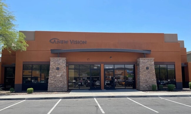
20325 N 51St Ave
Phoenix-Mesa-Scottsdale, AZ
Arrowhead Office Suites Condominium
206-29-022
ARROWHEAD OFFICE SUITES CONDOMINIUM MCR 817-40
Medicalbuilding
Maricopa
X
Arizona
04013C1270M
124
2025
0.04 AC
2025
Deer Valley/Airport
615900
Phoenix
6,139 SF
DEMOGRAPHICS near 20325 N 51St Ave
1 Mile
3 Mile
5 Mile
2024 Total Population
10,613
100,407
271,479
2029 Population
11,408
108,041
292,754
Pop Growth 2024-2029
+ 7.49%
+ 7.60%
+ 7.84%
Average Age
39
40
39
2024 Total Households
3,879
38,175
101,629
HH Growth 2024-2029
+ 7.50%
+ 7.72%
+ 8.00%
Median Household Inc
$91,975
$86,850
$81,708
Avg Household Size
2.60
2.50
2.60
2024 Avg HH Vehicles
2.00
2.00
2.00
Median Home Value
$357,496
$358,873
$360,680
Median Year Built
1991
1990
1990
Nearby Places
- Restaurants
- Banks
- Shops
- Fitness
- Groceries
PUBLIC TRANSPORTATION
AIRPORT
Phoenix Sky Harbor International
DRIVE
WALK
Distance
Phoenix Sky Harbor International
37 min
26.0 mi
Freight Ports
Port of San Diego
DRIVE
WALK
Distance
Port of San Diego
403 min
362.0 mi
Nearby Properties
Address
Land Use
TOTAL SIZE
Lot Size
Zoning
Address
Land Use
TOTAL SIZE
Lot Size
Zoning
159,642 SF
11.85 AC
C-C
Address
Land Use
TOTAL SIZE
Lot Size
Zoning
1,360,424 SF
88.31 AC
C-BP
Address
Land Use
TOTAL SIZE
Lot Size
Zoning
7,916 SF
5.26 AC
C-C
Address
Land Use
TOTAL SIZE
Lot Size
Zoning
53,813 SF
1,286.11 AC
Address
Land Use
TOTAL SIZE
Lot Size
Zoning
812,333 SF
31.75 AC
SR-30
Address
Land Use
TOTAL SIZE
Lot Size
Zoning
434,799 SF
69.70 AC
R-8
Address
Land Use
TOTAL SIZE
Lot Size
Zoning
284,223 SF
10.02 AC
C-C
Address
Land Use
TOTAL SIZE
Lot Size
Zoning
360,026 SF
74.94 AC
R-6
Address
Land Use
TOTAL SIZE
Lot Size
Zoning
0.47 AC
Address
Land Use
TOTAL SIZE
Lot Size
Zoning
291,137 SF
38.49 AC
AG
Address
Land Use
TOTAL SIZE
Lot Size
Zoning
361,228 SF
24.60 AC
I-P
Address
Land Use
TOTAL SIZE
Lot Size
Zoning
226,169 SF
20.48 AC
Address
Land Use
TOTAL SIZE
Lot Size
Zoning
296,753 SF
9.53 AC
CPBP
Address
Land Use
TOTAL SIZE
Lot Size
Zoning
228,085 SF
7.84 AC
I-P
Address
Land Use
TOTAL SIZE
Lot Size
Zoning
126,781 SF
10.06 AC
C-C
Address
Land Use
TOTAL SIZE
Lot Size
Zoning
344,908 SF
20.69 AC
C-C
Address
Land Use
TOTAL SIZE
Lot Size
Zoning
483,381 SF
27.83 AC
C-C
Address
Land Use
TOTAL SIZE
Lot Size
Zoning
126,814 SF
31.56 AC
R17
Address
Land Use
TOTAL SIZE
Lot Size
Zoning
244,979 SF
35.16 AC
C-BP
Address
Land Use
TOTAL SIZE
Lot Size
Zoning
430,038 SF
26.71 AC
M-H
Address
Land Use
TOTAL SIZE
Lot Size
Zoning
200,658 SF
23.14 AC
C-BP
Address
Land Use
TOTAL SIZE
Lot Size
Zoning
171,751 SF
8.61 AC
C-2
Address
Land Use
TOTAL SIZE
Lot Size
Zoning
98,628 SF
8.55 AC
R-43AG
Address
Land Use
TOTAL SIZE
Lot Size
Zoning
96,016 SF
4.47 AC
PAD
Address
Land Use
TOTAL SIZE
Lot Size
Zoning
102,816 SF
35.12 AC
AG
Address
Land Use
TOTAL SIZE
Lot Size
Zoning
104,166 SF
13.57 AC
R-6
Address
Land Use
TOTAL SIZE
Lot Size
Zoning
277,050 SF
16.54 AC
C-C
Address
Land Use
TOTAL SIZE
Lot Size
Zoning
209,546 SF
14.65 AC
M-M
Address
Land Use
TOTAL SIZE
Lot Size
Zoning
131,889 SF
7.31 AC
I-P
Address
Land Use
TOTAL SIZE
Lot Size
Zoning
88,542 SF
14.50 AC
R-10
The World's #1 Commercial Real Estate Marketplace
Connect with us
© 2025 CoStar Group
The information above has been obtained from sources believed reliable. While we do not doubt its accuracy we have not verified it and make no guarantee, warranty or representation about it. It is your responsibility to independently confirm its accuracy and completeness. Any projections, opinions, assumptions, or estimates used are for example only and do not represent the current or future performance of the property. The value of this transaction to you depends on tax and other factors which should be evaluated by your tax, financial, and legal advisors. You and your advisors should conduct a careful, independent investigation of the property to determine to your satisfaction the suitability of the property for your needs.