Property Record
2033 Milton Ave, Syracuse, NY 13209
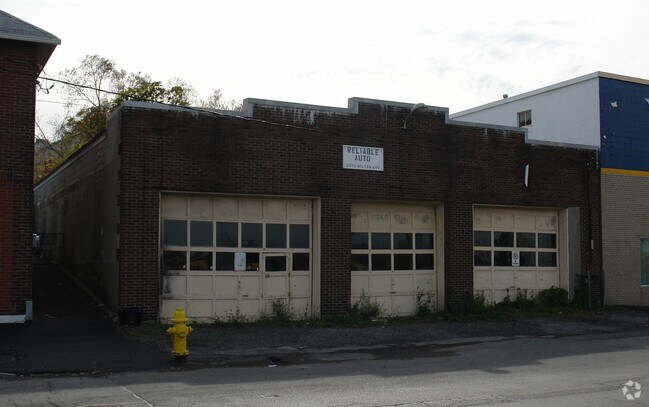

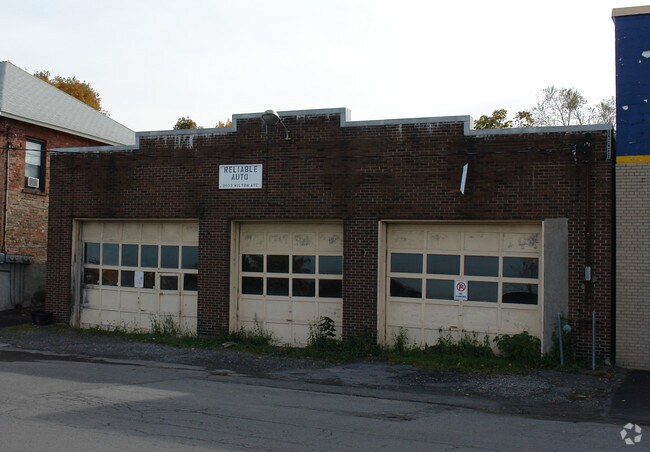
Property Detail
2033 Milton Ave
313201-007-000-0002-007-000-0000
G.C.GERE AMD BLK 2 LT 16 1115931
Autorepair
ONONDAGA
05 - COMME
New York
B and X Area of moderate flood hazard, usually the area between the limits of the 100-year and 500-year floods.
7.000
2025
0.13 AC
2024
W Outer Onondaga County
012900
Syracuse
4,000 SF
Syracuse, NY
NEARBY LISTINGS FOR SALE OR LEASE
-
-
-
-
-
-
-
-
-
No Photo
-
View all Syracuse listings for sale on LoopNet.com
DEMOGRAPHICS near 2033 Milton Ave
1 mile
3 mile
5 mile
2025 Total Population
6,881
58,129
195,402
2030 Population
6,809
57,380
193,784
Pop Growth 2025-2030
(1.05%)
(1.29%)
(0.83%)
Average Age
40
40
39
2025 Total Households
2,997
25,225
80,388
HH Growth 2025-2030
(1.30%)
(1.38%)
(0.85%)
Median Household Inc
$65,542
$67,115
$59,676
Avg Household Size
2.20
2.20
2.20
2025 Avg HH Vehicles
1.00
1.00
1.00
Median Home Value
$156,371
$167,350
$165,975
Median Year Built
1949
1954
1955
Nearby Places
Map Layers
Map Styles
 Street
 Aerial
Layers
 Traffic
 Biking
Places
Listings with unknown addresses are not visible on the map
- Restaurants
- Banks
- Shops
- Fitness
- Groceries
PUBLIC TRANSPORTATION
COMMUTER RAIL
Drive
Walk
Distance
9 min
3.7 mi
AIRPORT
Syracuse Hancock International
Drive
Walk
Distance
Syracuse Hancock International
17 min
8.3 mi
Nearby Properties
Address
Land Use
TOTAL SIZE
Lot Size
Zoning
Address
Land Use
TOTAL SIZE
Lot Size
Zoning
847,042 SF
42.78 AC
23
Address
Land Use
TOTAL SIZE
Lot Size
Zoning
57,011 SF
22.53 AC
22
Address
Land Use
TOTAL SIZE
Lot Size
Zoning
848,000 SF
30.29 AC
Address
Land Use
TOTAL SIZE
Lot Size
Zoning
52,800 SF
691.95 AC
06 - INDUS
Address
Land Use
TOTAL SIZE
Lot Size
Zoning
6,106 SF
32.71 AC
06
Address
Land Use
TOTAL SIZE
Lot Size
Zoning
316,848 SF
10.72 AC
08 - GOVER
Address
Land Use
TOTAL SIZE
Lot Size
Zoning
22,692 SF
28.07 AC
03 - MULTI
Address
Land Use
TOTAL SIZE
Lot Size
Zoning
23,650 SF
146.50 AC
06 - INDUS
Address
Land Use
TOTAL SIZE
Lot Size
Zoning
216,079 SF
17.57 AC
06 - INDUS
Address
Land Use
TOTAL SIZE
Lot Size
Zoning
285,000 SF
10.94 AC
23
Address
Land Use
TOTAL SIZE
Lot Size
Zoning
270,834 SF
29.38 AC
05 - COMME
Address
Land Use
TOTAL SIZE
Lot Size
Zoning
58,012 SF
21.64 AC
02 - SINGL
Address
Land Use
TOTAL SIZE
Lot Size
Zoning
35,848 SF
1.68 AC
05 - COMME
Address
Land Use
TOTAL SIZE
Lot Size
Zoning
377,454 SF
5.27 AC
15
Address
Land Use
TOTAL SIZE
Lot Size
Zoning
55,542 SF
1.62 AC
22
Address
Land Use
TOTAL SIZE
Lot Size
Zoning
367,188 SF
22
Address
Land Use
TOTAL SIZE
Lot Size
Zoning
97,439 SF
24.52 AC
05 - COMME
Address
Land Use
TOTAL SIZE
Lot Size
Zoning
10,200 SF
5.96 AC
03 - MULTI
Address
Land Use
TOTAL SIZE
Lot Size
Zoning
91,264 SF
1.59 AC
Address
Land Use
TOTAL SIZE
Lot Size
Zoning
127,391 SF
11.68 AC
05 - COMME
Address
Land Use
TOTAL SIZE
Lot Size
Zoning
11,952 SF
9.14 AC
03 - MULTI
Address
Land Use
TOTAL SIZE
Lot Size
Zoning
42,189 SF
8.60 AC
02 - SINGL
Address
Land Use
TOTAL SIZE
Lot Size
Zoning
38,000 SF
9.90 AC
22
Address
Land Use
TOTAL SIZE
Lot Size
Zoning
147,250 SF
0.50 AC
02 - SINGL
Address
Land Use
TOTAL SIZE
Lot Size
Zoning
65,027 SF
262.57 AC
06 - INDUS
Address
Land Use
TOTAL SIZE
Lot Size
Zoning
106,338 SF
7.70 AC
05 - COMME
Address
Land Use
TOTAL SIZE
Lot Size
Zoning
864 SF
3.07 AC
16
Address
Land Use
TOTAL SIZE
Lot Size
Zoning
12,325 SF
16.12 AC
07 - MIXED
Address
Land Use
TOTAL SIZE
Lot Size
Zoning
157,675 SF
12.88 AC
Address
Land Use
TOTAL SIZE
Lot Size
Zoning
71,074 SF
27.78 AC
02 - SINGL
The World's #1 Commercial Real Estate Marketplace
Connect with us
© 2026 CoStar Group
The information above has been obtained from sources believed reliable. While we do not doubt its accuracy we have not verified it and make no guarantee, warranty or representation about it. It is your responsibility to independently confirm its accuracy and completeness. Any projections, opinions, assumptions, or estimates used are for example only and do not represent the current or future performance of the property. The value of this transaction to you depends on tax and other factors which should be evaluated by your tax, financial, and legal advisors. You and your advisors should conduct a careful, independent investigation of the property to determine to your satisfaction the suitability of the property for your needs.