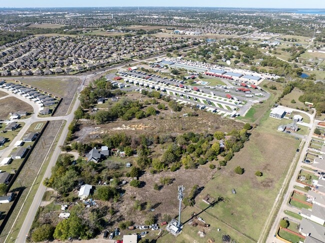
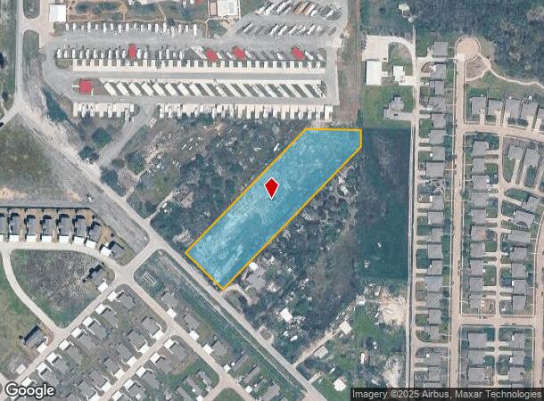
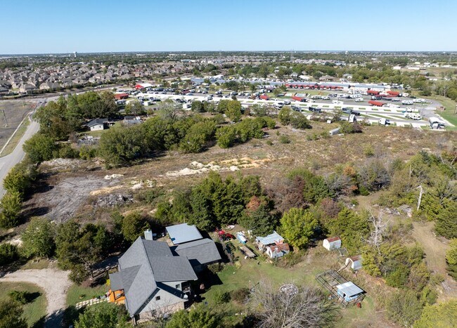
Property Record
2033 Vinson Rd, Wylie, TX 75098

This Property Is For Sale
NEARBY LISTINGS FOR SALE OR LEASE
Property Detail
2033 Vinson Rd
Dallas-Fort Worth-Arlington, TX
Nathan Atterbury
65176374510070000
NATHAN ATTERBURY ABST 1763 PG 745 TR 7 ACS 3.1316 JURIS SPLIT 0.1261 AC IN COLLIN INT202300160046 DD08072023 CO-DC 1763745100700 1NT17637451
Residentialacreage
Dallas
X
Texas
48113C0235K
3.13 AC
2024
Garland
2025
Dallas/Ft Worth
031321
DEMOGRAPHICS near 2033 Vinson Rd
1 Mile
3 Mile
5 Mile
2024 Total Population
4,878
50,193
147,787
2029 Population
5,777
58,169
173,049
Pop Growth 2024-2029
+ 18.43%
+ 15.89%
+ 17.09%
Average Age
36
37
38
2024 Total Households
1,471
16,002
47,326
HH Growth 2024-2029
+ 17.95%
+ 15.89%
+ 17.31%
Median Household Inc
$113,909
$110,488
$113,212
Avg Household Size
3.30
3.10
3.10
2024 Avg HH Vehicles
3.00
2.00
2.00
Median Home Value
$347,270
$327,529
$317,343
Median Year Built
2006
2004
2004
Nearby Places
Map Layers
Map Styles
 Street
 Aerial
- Restaurants
- Banks
- Shops
- Fitness
- Groceries
PUBLIC TRANSPORTATION
AIRPORT
Dallas Love Field
DRIVE
WALK
Distance
Dallas Love Field
47 min
32.0 mi
Freight Ports
Port of Shreveport
DRIVE
WALK
Distance
Port of Shreveport
224 min
194.5 mi
Nearby Properties
Address
Land Use
TOTAL SIZE
Lot Size
Zoning
Address
Land Use
TOTAL SIZE
Lot Size
Zoning
603,573 SF
58.20 AC
Address
Land Use
TOTAL SIZE
Lot Size
Zoning
266,957 SF
11.34 AC
MFR
Address
Land Use
TOTAL SIZE
Lot Size
Zoning
393,054 SF
55.95 AC
Address
Land Use
TOTAL SIZE
Lot Size
Zoning
228,536 SF
10.54 AC
MF-M
Address
Land Use
TOTAL SIZE
Lot Size
Zoning
274,416 SF
18.40 AC
PD
Address
Land Use
TOTAL SIZE
Lot Size
Zoning
132,306 SF
7.85 AC
MF
Address
Land Use
TOTAL SIZE
Lot Size
Zoning
83,296 SF
14.88 AC
Z01
Address
Land Use
TOTAL SIZE
Lot Size
Zoning
106,866 SF
15.69 AC
Address
Land Use
TOTAL SIZE
Lot Size
Zoning
97,898 SF
10.82 AC
Address
Land Use
TOTAL SIZE
Lot Size
Zoning
203,192 SF
17.69 AC
Address
Land Use
TOTAL SIZE
Lot Size
Zoning
128,849 SF
7.70 AC
Address
Land Use
TOTAL SIZE
Lot Size
Zoning
304,978 SF
81.51 AC
Address
Land Use
TOTAL SIZE
Lot Size
Zoning
221,982 SF
17.21 AC
Address
Land Use
TOTAL SIZE
Lot Size
Zoning
79,346 SF
10.42 AC
Address
Land Use
TOTAL SIZE
Lot Size
Zoning
145,635 SF
12.15 AC
Address
Land Use
TOTAL SIZE
Lot Size
Zoning
125,000 SF
22.42 AC
FLOOD
Address
Land Use
TOTAL SIZE
Lot Size
Zoning
91,585 SF
4.33 AC
I
Address
Land Use
TOTAL SIZE
Lot Size
Zoning
106,826 SF
8.04 AC
Address
Land Use
TOTAL SIZE
Lot Size
Zoning
151,759 SF
14.02 AC
MF
Address
Land Use
TOTAL SIZE
Lot Size
Zoning
109 SF
17.90 AC
Z268
Address
Land Use
TOTAL SIZE
Lot Size
Zoning
54,240 SF
2.12 AC
MF
Address
Land Use
TOTAL SIZE
Lot Size
Zoning
33,638 SF
7.14 AC
AG
Address
Land Use
TOTAL SIZE
Lot Size
Zoning
67,031 SF
18.83 AC
Address
Land Use
TOTAL SIZE
Lot Size
Zoning
3,027 SF
108.32 AC
SUP
Address
Land Use
TOTAL SIZE
Lot Size
Zoning
408,994 SF
33.67 AC
I
Address
Land Use
TOTAL SIZE
Lot Size
Zoning
94,981 SF
11.55 AC
Address
Land Use
TOTAL SIZE
Lot Size
Zoning
1,600 SF
16.22 AC
PD
Address
Land Use
TOTAL SIZE
Lot Size
Zoning
40,762 SF
4.70 AC
CR
Address
Land Use
TOTAL SIZE
Lot Size
Zoning
19,026 SF
77.70 AC
Z236
Address
Land Use
TOTAL SIZE
Lot Size
Zoning
108,582 SF
10 AC
The World's #1 Commercial Real Estate Marketplace
Connect with us
© 2025 CoStar Group
The information above has been obtained from sources believed reliable. While we do not doubt its accuracy we have not verified it and make no guarantee, warranty or representation about it. It is your responsibility to independently confirm its accuracy and completeness. Any projections, opinions, assumptions, or estimates used are for example only and do not represent the current or future performance of the property. The value of this transaction to you depends on tax and other factors which should be evaluated by your tax, financial, and legal advisors. You and your advisors should conduct a careful, independent investigation of the property to determine to your satisfaction the suitability of the property for your needs.