Property Record
20331 Fm 529 Rd, Cypress, TX 77433
NEARBY LISTINGS FOR SALE OR LEASE
-
-
-
-
-
No Photo
-
-
-
View all Cypress listings for lease on LoopNet.com
Property Detail
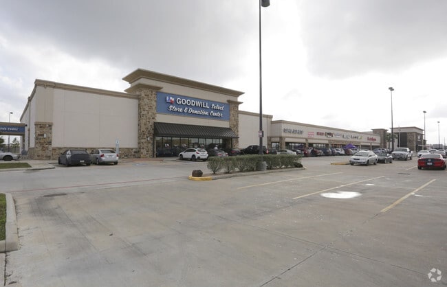
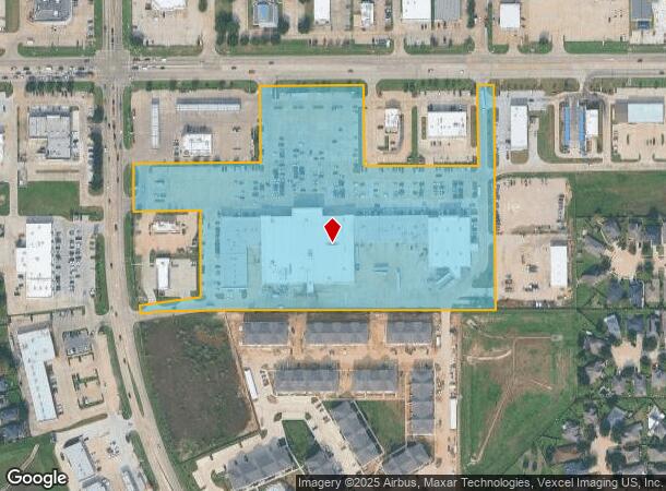
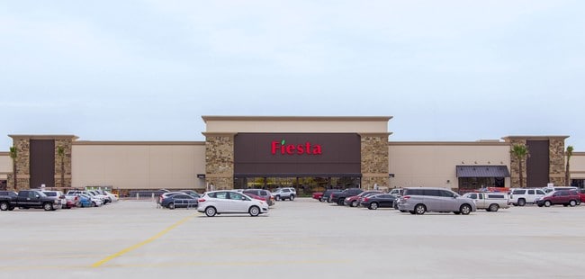
20331 Fm 529 Rd
1366010010002
Fry 529 Center
Regionalshoppingcenterormallwithanchorstore
RES B BLK 1 FRY 529 CENTER
X
Harris
48201C0415N
Texas
2024
12.44 AC
2025
Far Katy North
542106
Houston
117,860 SF
Houston-Pasadena-The Woodlands, TX
DEMOGRAPHICS near 20331 Fm 529 Rd
1 mile
3 mile
5 mile
2024 Total Population
20,985
123,107
306,944
2029 Population
21,197
125,892
314,536
Pop Growth 2024-2029
+ 1.01%
+ 2.26%
+ 2.47%
Average Age
34
34
35
2024 Total Households
5,976
35,731
92,713
HH Growth 2024-2029
+ 0.97%
+ 2.21%
+ 2.39%
Median Household Inc
$85,172
$87,314
$91,639
Avg Household Size
3.40
3.40
3.30
2024 Avg HH Vehicles
2.00
2.00
2.00
Median Home Value
$185,121
$219,255
$240,025
Median Year Built
2003
2006
2005
Nearby Places
Map Layers
Map Styles
 Street
 Aerial
Transit
 Traffic
 Biking
Places
Listings with unknown addresses are not visible on the map
- Restaurants
- Banks
- Shops
- Fitness
- Groceries
PUBLIC TRANSPORTATION
AIRPORT
George Bush Intcntl/Houston
Drive
Walk
Distance
George Bush Intcntl/Houston
43 min
28.7 mi
William P Hobby
Drive
Walk
Distance
William P Hobby
62 min
39.4 mi
SALE & LEASE HISTORY
LISTING DATE
SALE/LEASE

Sep 25, 2016
For Lease
Jun 11, 2022
For Lease
Apr 21, 2020
For Lease
Nearby Properties
Address
Land Use
TOTAL SIZE
Lot Size
Zoning
Address
Land Use
TOTAL SIZE
Lot Size
Zoning
838,700 SF
36.68 AC
Address
Land Use
TOTAL SIZE
Lot Size
Zoning
483,699 SF
13 AC
Address
Land Use
TOTAL SIZE
Lot Size
Zoning
355,721 SF
13 AC
Address
Land Use
TOTAL SIZE
Lot Size
Zoning
351,997 SF
13.28 AC
Address
Land Use
TOTAL SIZE
Lot Size
Zoning
323,609 SF
12.71 AC
Address
Land Use
TOTAL SIZE
Lot Size
Zoning
331,263 SF
11.36 AC
Address
Land Use
TOTAL SIZE
Lot Size
Zoning
236,406 SF
11.40 AC
Address
Land Use
TOTAL SIZE
Lot Size
Zoning
418,572 SF
24.76 AC
Address
Land Use
TOTAL SIZE
Lot Size
Zoning
262,174 SF
11.64 AC
Address
Land Use
TOTAL SIZE
Lot Size
Zoning
267,766 SF
12.96 AC
Address
Land Use
TOTAL SIZE
Lot Size
Zoning
290,927 SF
14.53 AC
Address
Land Use
TOTAL SIZE
Lot Size
Zoning
240,710 SF
18.80 AC
Address
Land Use
TOTAL SIZE
Lot Size
Zoning
279,000 SF
4.30 AC
Address
Land Use
TOTAL SIZE
Lot Size
Zoning
147,923 SF
11.60 AC
Address
Land Use
TOTAL SIZE
Lot Size
Zoning
262,048 SF
7 AC
Address
Land Use
TOTAL SIZE
Lot Size
Zoning
228,152 SF
22.61 AC
Address
Land Use
TOTAL SIZE
Lot Size
Zoning
191,575 SF
17.98 AC
Address
Land Use
TOTAL SIZE
Lot Size
Zoning
122,880 SF
15 AC
Address
Land Use
TOTAL SIZE
Lot Size
Zoning
99,096 SF
27.51 AC
Address
Land Use
TOTAL SIZE
Lot Size
Zoning
201,809 SF
21.18 AC
Address
Land Use
TOTAL SIZE
Lot Size
Zoning
67,250 SF
7.37 AC
Address
Land Use
TOTAL SIZE
Lot Size
Zoning
2,939 SF
330.19 AC
Address
Land Use
TOTAL SIZE
Lot Size
Zoning
46,225 SF
6.74 AC
Address
Land Use
TOTAL SIZE
Lot Size
Zoning
163,770 SF
5.08 AC
Address
Land Use
TOTAL SIZE
Lot Size
Zoning
84.23 AC
Address
Land Use
TOTAL SIZE
Lot Size
Zoning
52,035 SF
9.23 AC
Address
Land Use
TOTAL SIZE
Lot Size
Zoning
99,883 SF
3.16 AC
Address
Land Use
TOTAL SIZE
Lot Size
Zoning
64,627 SF
4.37 AC
Address
Land Use
TOTAL SIZE
Lot Size
Zoning
126,890 SF
6.29 AC
The World's #1 Commercial Real Estate Marketplace
Connect with us
© 2026 CoStar Group
The information above has been obtained from sources believed reliable. While we do not doubt its accuracy we have not verified it and make no guarantee, warranty or representation about it. It is your responsibility to independently confirm its accuracy and completeness. Any projections, opinions, assumptions, or estimates used are for example only and do not represent the current or future performance of the property. The value of this transaction to you depends on tax and other factors which should be evaluated by your tax, financial, and legal advisors. You and your advisors should conduct a careful, independent investigation of the property to determine to your satisfaction the suitability of the property for your needs.