Property Record
2034 Laporte Rd, Waterloo, IA 50702
NEARBY LISTINGS FOR SALE OR LEASE
-
-
View all Waterloo listings for sale on LoopNet.com
Property Detail
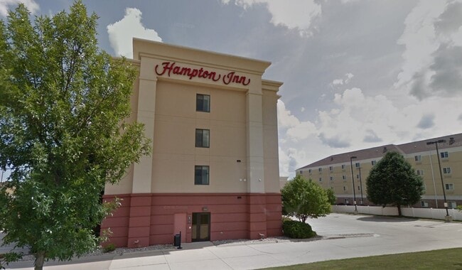
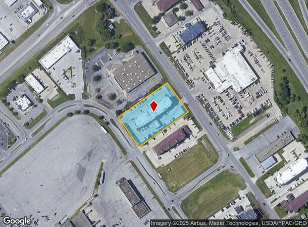
2034 Laporte Rd
Waterloo-Cedar Falls, IA
Crossroads Plat No 8 A Replat
8813-02-277-015
CROSSROADS PLAT NO 8 A REPLAT OF PART OF TRACT XG CROSSROADS PLAT NO 1 LOT 1
Hotelormotel
Black Hawk
X
Iowa
19013C0304G
1
2024
1.66 AC
2025
Iowa City/Waterloo
000900
Other Market Areas
59,016 SF
DEMOGRAPHICS near 2034 Laporte Rd
1 mile
3 mile
5 mile
2024 Total Population
3,997
47,796
72,392
2029 Population
3,954
47,604
71,951
Pop Growth 2024-2029
(1.08%)
(0.40%)
(0.61%)
Average Age
38
39
39
2024 Total Households
1,819
20,550
31,198
HH Growth 2024-2029
(1.10%)
(0.34%)
(0.60%)
Median Household Inc
$44,672
$51,216
$52,281
Avg Household Size
2.10
2.20
2.20
2024 Avg HH Vehicles
1.00
2.00
2.00
Median Home Value
$146,460
$138,341
$140,673
Median Year Built
1963
1961
1961
Nearby Places
Map Layers
Map Styles
 Street
 Aerial
Transit
 Traffic
 Biking
Places
Listings with unknown addresses are not visible on the map
- Restaurants
- Banks
- Shops
- Fitness
- Groceries
Nearby Properties
Address
Land Use
TOTAL SIZE
Lot Size
Zoning
Address
Land Use
TOTAL SIZE
Lot Size
Zoning
156,098 SF
52.58 AC
Address
Land Use
TOTAL SIZE
Lot Size
Zoning
596,653 SF
31.45 AC
Address
Land Use
TOTAL SIZE
Lot Size
Zoning
1,144 SF
306.57 AC
Address
Land Use
TOTAL SIZE
Lot Size
Zoning
108,671 SF
3.72 AC
Address
Land Use
TOTAL SIZE
Lot Size
Zoning
186,130 SF
10.89 AC
Address
Land Use
TOTAL SIZE
Lot Size
Zoning
622 SF
106.81 AC
Address
Land Use
TOTAL SIZE
Lot Size
Zoning
341 SF
1.83 AC
Address
Land Use
TOTAL SIZE
Lot Size
Zoning
101,633 SF
7 AC
Address
Land Use
TOTAL SIZE
Lot Size
Zoning
110,177 SF
1.19 AC
Address
Land Use
TOTAL SIZE
Lot Size
Zoning
202,974 SF
19.11 AC
Address
Land Use
TOTAL SIZE
Lot Size
Zoning
174,244 SF
34.27 AC
Address
Land Use
TOTAL SIZE
Lot Size
Zoning
1,473 SF
25.70 AC
Address
Land Use
TOTAL SIZE
Lot Size
Zoning
2,735 SF
158.87 AC
Address
Land Use
TOTAL SIZE
Lot Size
Zoning
59,565 SF
0.28 AC
Address
Land Use
TOTAL SIZE
Lot Size
Zoning
205,163 SF
15 AC
Address
Land Use
TOTAL SIZE
Lot Size
Zoning
115,819 SF
2.07 AC
Address
Land Use
TOTAL SIZE
Lot Size
Zoning
129,863 SF
11.40 AC
Address
Land Use
TOTAL SIZE
Lot Size
Zoning
125,340 SF
0.80 AC
Address
Land Use
TOTAL SIZE
Lot Size
Zoning
60,496 SF
4.96 AC
Address
Land Use
TOTAL SIZE
Lot Size
Zoning
197,968 SF
6.10 AC
Address
Land Use
TOTAL SIZE
Lot Size
Zoning
82,449 SF
10.62 AC
Address
Land Use
TOTAL SIZE
Lot Size
Zoning
157,119 SF
15.78 AC
Address
Land Use
TOTAL SIZE
Lot Size
Zoning
77,366 SF
38.51 AC
Address
Land Use
TOTAL SIZE
Lot Size
Zoning
86,363 SF
21.46 AC
Address
Land Use
TOTAL SIZE
Lot Size
Zoning
960 SF
39.19 AC
Address
Land Use
TOTAL SIZE
Lot Size
Zoning
70,933 SF
27.58 AC
Address
Land Use
TOTAL SIZE
Lot Size
Zoning
102,131 SF
9.16 AC
Address
Land Use
TOTAL SIZE
Lot Size
Zoning
71,035 SF
8.27 AC
Address
Land Use
TOTAL SIZE
Lot Size
Zoning
145,720 SF
17.98 AC
Address
Land Use
TOTAL SIZE
Lot Size
Zoning
84,388 SF
7.79 AC
The World's #1 Commercial Real Estate Marketplace
Connect with us
© 2026 CoStar Group
The information above has been obtained from sources believed reliable. While we do not doubt its accuracy we have not verified it and make no guarantee, warranty or representation about it. It is your responsibility to independently confirm its accuracy and completeness. Any projections, opinions, assumptions, or estimates used are for example only and do not represent the current or future performance of the property. The value of this transaction to you depends on tax and other factors which should be evaluated by your tax, financial, and legal advisors. You and your advisors should conduct a careful, independent investigation of the property to determine to your satisfaction the suitability of the property for your needs.