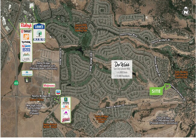
Property Record
2035 Camino Verdera, Lincoln, CA 95648


NEARBY LISTINGS FOR SALE OR LEASE
-
-
View all Lincoln listings for sale on LoopNet.com
Property Detail
2035 Camino Verdera
Sacramento--Roseville--Arden-Arcade, CA
Verdera Large Lot Subd
337-012-016
5.2 AC LOT 302 VERDERA LARGE LOT SUBD MOR Z-32
Vacantlandnec
Placer
X
California
06061C0951H
302
2024
5.20 AC
2025
Roseville/Rocklin
023501
Sacramento
DEMOGRAPHICS near 2035 Camino Verdera
1 Mile
3 Mile
5 Mile
2024 Total Population
4,972
46,214
126,429
2029 Population
5,479
50,212
136,384
Pop Growth 2024-2029
+ 10.20%
+ 8.65%
+ 7.87%
Average Age
56
47
42
2024 Total Households
2,227
18,111
45,718
HH Growth 2024-2029
+ 9.47%
+ 8.41%
+ 7.85%
Median Household Inc
$110,406
$111,141
$107,345
Avg Household Size
2.20
2.50
2.70
2024 Avg HH Vehicles
2.00
2.00
2.00
Median Home Value
$746,886
$724,021
$684,266
Median Year Built
2006
2004
2001
Nearby Places
Map Layers
Map Styles
 Street
 Aerial
- Restaurants
- Banks
- Shops
- Fitness
- Groceries
PUBLIC TRANSPORTATION
COMMUTER RAIL
Rocklin Amtrak Station (Capitol Corridor - Amtrak)
DRIVE
WALK
Distance
Rocklin Amtrak Station (Capitol Corridor - Amtrak)
15 min
8.8 mi
AIRPORT
Sacramento International
DRIVE
WALK
Distance
Sacramento International
49 min
37.1 mi
Freight Ports
Port of Stockton
DRIVE
WALK
Distance
Port of Stockton
92 min
77.3 mi
SALE & LEASE HISTORY
LISTING DATE
SALE/LEASE

Feb 28, 2020
For Sale
Nearby Properties
Address
Land Use
TOTAL SIZE
Lot Size
Zoning
Address
Land Use
TOTAL SIZE
Lot Size
Zoning
96,413 SF
7.65 AC
Address
Land Use
TOTAL SIZE
Lot Size
Zoning
93,992 SF
6.90 AC
Address
Land Use
TOTAL SIZE
Lot Size
Zoning
75,138 SF
10.30 AC
Address
Land Use
TOTAL SIZE
Lot Size
Zoning
190,578 SF
11.90 AC
Address
Land Use
TOTAL SIZE
Lot Size
Zoning
88,464 SF
7.40 AC
Address
Land Use
TOTAL SIZE
Lot Size
Zoning
72,638 SF
7.90 AC
Address
Land Use
TOTAL SIZE
Lot Size
Zoning
140,013 SF
12.10 AC
Address
Land Use
TOTAL SIZE
Lot Size
Zoning
7.70 AC
Address
Land Use
TOTAL SIZE
Lot Size
Zoning
89,624 SF
10.10 AC
Address
Land Use
TOTAL SIZE
Lot Size
Zoning
41.20 AC
Address
Land Use
TOTAL SIZE
Lot Size
Zoning
45,374 SF
16 AC
Address
Land Use
TOTAL SIZE
Lot Size
Zoning
45,500 SF
2.89 AC
Address
Land Use
TOTAL SIZE
Lot Size
Zoning
29,758 SF
229.50 AC
Address
Land Use
TOTAL SIZE
Lot Size
Zoning
57,559 SF
6.20 AC
Address
Land Use
TOTAL SIZE
Lot Size
Zoning
2.36 AC
Address
Land Use
TOTAL SIZE
Lot Size
Zoning
2,625 SF
46.55 AC
Address
Land Use
TOTAL SIZE
Lot Size
Zoning
22,370 SF
3 AC
Address
Land Use
TOTAL SIZE
Lot Size
Zoning
7,968 SF
1.30 AC
Address
Land Use
TOTAL SIZE
Lot Size
Zoning
14,490 SF
2.20 AC
Address
Land Use
TOTAL SIZE
Lot Size
Zoning
11,520 SF
1.40 AC
Address
Land Use
TOTAL SIZE
Lot Size
Zoning
12.50 AC
Address
Land Use
TOTAL SIZE
Lot Size
Zoning
16,558 SF
3.50 AC
Address
Land Use
TOTAL SIZE
Lot Size
Zoning
8.40 AC
Address
Land Use
TOTAL SIZE
Lot Size
Zoning
14,890 SF
5.60 AC
Address
Land Use
TOTAL SIZE
Lot Size
Zoning
23,032 SF
2.60 AC
Address
Land Use
TOTAL SIZE
Lot Size
Zoning
11,650 SF
2 AC
Address
Land Use
TOTAL SIZE
Lot Size
Zoning
16,961 SF
5.50 AC
Address
Land Use
TOTAL SIZE
Lot Size
Zoning
15,280 SF
198.40 AC
FBXMRS
The World's #1 Commercial Real Estate Marketplace
Connect with us
© 2025 CoStar Group
The information above has been obtained from sources believed reliable. While we do not doubt its accuracy we have not verified it and make no guarantee, warranty or representation about it. It is your responsibility to independently confirm its accuracy and completeness. Any projections, opinions, assumptions, or estimates used are for example only and do not represent the current or future performance of the property. The value of this transaction to you depends on tax and other factors which should be evaluated by your tax, financial, and legal advisors. You and your advisors should conduct a careful, independent investigation of the property to determine to your satisfaction the suitability of the property for your needs.