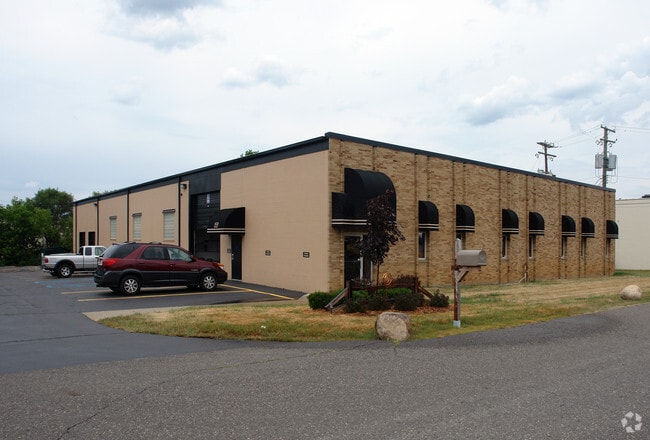
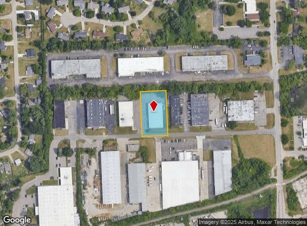
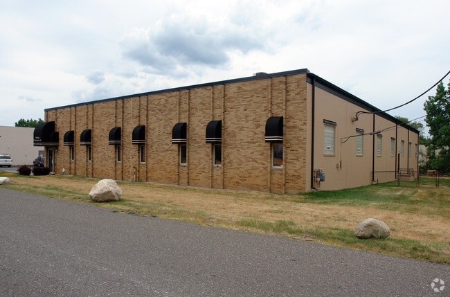
Property Record
2035 Easy St, Commerce Township, MI 48390

NEARBY LISTINGS FOR SALE OR LEASE
Property Detail
2035 Easy St
17-26-426-061
T2N, R8E, SEC 26 PART OF SE 1/4 BEG AT PT DIST S 00-02-00 W 1304 FT & N 89-38-00 W 633 FT FROM E 1/4 COR, TH S 00-02-00 W 259.38 FT, TH N 89-38-00 W 150 FT, TH N 00-02-00 E 259.38 FT, TH S 89-38-00 E 150 FT TO BEG 0.89 A 1/5/88 FR 013
Manufacturinglight
Oakland
X
Michigan
26125C0487F
0.89 AC
2024
Central I-96 Corridor
2024
Detroit
134800
Detroit-Warren-Dearborn, MI
11,421 SF
DEMOGRAPHICS near 2035 Easy St
1 Mile
3 Mile
5 Mile
2024 Total Population
5,871
65,305
147,469
2029 Population
5,801
64,875
145,864
Pop Growth 2024-2029
(1.19%)
(0.66%)
(1.09%)
Average Age
45
44
43
2024 Total Households
2,698
28,438
61,124
HH Growth 2024-2029
(1.19%)
(0.60%)
(1.14%)
Median Household Inc
$69,856
$85,467
$94,778
Avg Household Size
2.20
2.20
2.40
2024 Avg HH Vehicles
2.00
2.00
2.00
Median Home Value
$250,367
$324,341
$337,334
Median Year Built
1986
1990
1986
Nearby Places
Map Layers
Map Styles
 Street
 Aerial
- Restaurants
- Banks
- Shops
- Fitness
- Groceries
PUBLIC TRANSPORTATION
AIRPORT
Detroit Metro Wayne County
DRIVE
WALK
Distance
Detroit Metro Wayne County
42 min
31.4 mi
Bishop International
DRIVE
WALK
Distance
Bishop International
66 min
41.3 mi
Windsor International
DRIVE
WALK
Distance
Windsor International
65 min
41.6 mi
SALE & LEASE HISTORY
LISTING DATE
SALE/LEASE

Nov 06, 2018
For Lease
Jul 10, 2023
For Sale
Aug 09, 2022
For Lease
Nearby Properties
Address
Land Use
TOTAL SIZE
Lot Size
Zoning
Address
Land Use
TOTAL SIZE
Lot Size
Zoning
162,600 SF
102.81 AC
RM-1
Address
Land Use
TOTAL SIZE
Lot Size
Zoning
308,794 SF
76.30 AC
RI
Address
Land Use
TOTAL SIZE
Lot Size
Zoning
614,079 SF
57.44 AC
Address
Land Use
TOTAL SIZE
Lot Size
Zoning
72.63 AC
RM-1
Address
Land Use
TOTAL SIZE
Lot Size
Zoning
659,897 SF
53.96 AC
AI
Address
Land Use
TOTAL SIZE
Lot Size
Zoning
400,505 SF
26.50 AC
Address
Land Use
TOTAL SIZE
Lot Size
Zoning
59.71 AC
RM-1
Address
Land Use
TOTAL SIZE
Lot Size
Zoning
17,277 SF
17.73 AC
R-A
Address
Land Use
TOTAL SIZE
Lot Size
Zoning
427,062 SF
31.20 AC
AI
Address
Land Use
TOTAL SIZE
Lot Size
Zoning
411,118 SF
43.95 AC
AI
Address
Land Use
TOTAL SIZE
Lot Size
Zoning
274,645 SF
39.27 AC
AI
Address
Land Use
TOTAL SIZE
Lot Size
Zoning
Address
Land Use
TOTAL SIZE
Lot Size
Zoning
367,354 SF
62.73 AC
AI
Address
Land Use
TOTAL SIZE
Lot Size
Zoning
188,643 SF
12.81 AC
IV
Address
Land Use
TOTAL SIZE
Lot Size
Zoning
269,975 SF
23.88 AC
AI
Address
Land Use
TOTAL SIZE
Lot Size
Zoning
287,023 SF
22.20 AC
Address
Land Use
TOTAL SIZE
Lot Size
Zoning
226,834 SF
21.59 AC
AI
Address
Land Use
TOTAL SIZE
Lot Size
Zoning
249,084 SF
19.65 AC
AI
Address
Land Use
TOTAL SIZE
Lot Size
Zoning
115,400 SF
9.38 AC
BI
Address
Land Use
TOTAL SIZE
Lot Size
Zoning
19.26 AC
R-A
Address
Land Use
TOTAL SIZE
Lot Size
Zoning
2,073 SF
116.28 AC
MH
Address
Land Use
TOTAL SIZE
Lot Size
Zoning
260,330 SF
21.04 AC
AI
Address
Land Use
TOTAL SIZE
Lot Size
Zoning
7,646 SF
24.55 AC
RM1
Address
Land Use
TOTAL SIZE
Lot Size
Zoning
244,500 SF
7.80 AC
AI
Address
Land Use
TOTAL SIZE
Lot Size
Zoning
222,664 SF
21.10 AC
BI
Address
Land Use
TOTAL SIZE
Lot Size
Zoning
140,014 SF
30.70 AC
OST
Address
Land Use
TOTAL SIZE
Lot Size
Zoning
Address
Land Use
TOTAL SIZE
Lot Size
Zoning
147,714 SF
13.54 AC
OST
Address
Land Use
TOTAL SIZE
Lot Size
Zoning
196,222 SF
Address
Land Use
TOTAL SIZE
Lot Size
Zoning
168,532 SF
11.83 AC
AI
The World's #1 Commercial Real Estate Marketplace
Connect with us
© 2025 CoStar Group
The information above has been obtained from sources believed reliable. While we do not doubt its accuracy we have not verified it and make no guarantee, warranty or representation about it. It is your responsibility to independently confirm its accuracy and completeness. Any projections, opinions, assumptions, or estimates used are for example only and do not represent the current or future performance of the property. The value of this transaction to you depends on tax and other factors which should be evaluated by your tax, financial, and legal advisors. You and your advisors should conduct a careful, independent investigation of the property to determine to your satisfaction the suitability of the property for your needs.