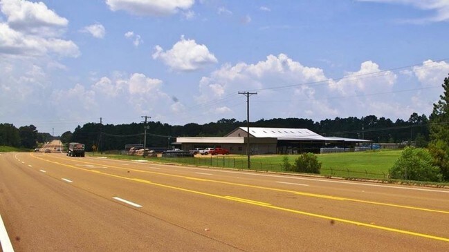
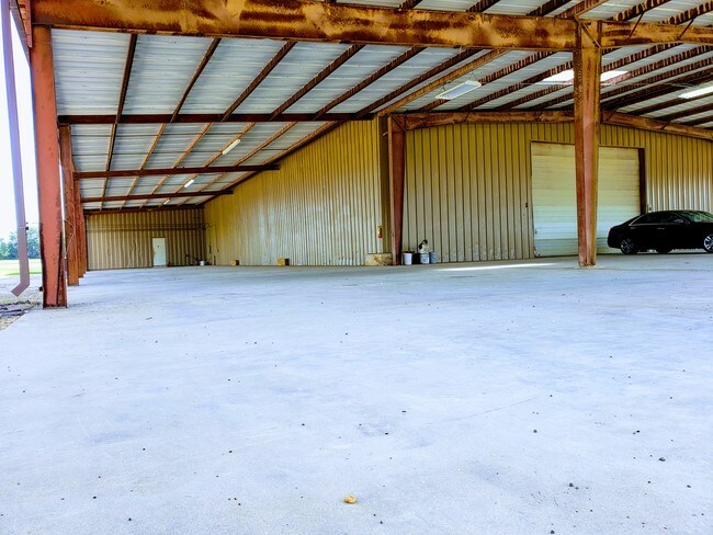
Property Record
2035 Highway 98 E, Mccomb, MS 39648

Property Detail
2035 Highway 98 E
811773-B
FRAC TCT N & E OF HWY 98 SW1/4 NW1/4 SE1/4 & NW1/4 SW1/4 SE1/4 ZN:X-28113C0125C
Storebuilding
Pike
B and X Area of moderate flood hazard, usually the area between the limits of the 100-year and 500-year floods.
Mississippi
2025
4 AC
2025
Other Market Areas
950103
McComb, MS
4,081 SF
NEARBY LISTINGS FOR SALE OR LEASE
-
-
View all Mccomb listings for sale on LoopNet.com
DEMOGRAPHICS near 2035 Highway 98 E
1 mile
3 mile
5 mile
2025 Total Population
446
10,303
20,713
2030 Population
427
10,009
20,123
Pop Growth 2025-2030
(4.26%)
(2.85%)
(2.85%)
Average Age
38
38
39
2025 Total Households
169
4,017
8,271
HH Growth 2025-2030
(4.14%)
(2.81%)
(2.83%)
Median Household Inc
$33,289
$40,580
$41,619
Avg Household Size
2.60
2.50
2.40
2025 Avg HH Vehicles
2.00
2.00
2.00
Median Home Value
$150,000
$120,889
$122,417
Median Year Built
1981
1977
1979
Nearby Places
Map Layers
Map Styles
 Street
 Aerial
Transit
 Traffic
 Biking
Places
Listings with unknown addresses are not visible on the map
- Restaurants
- Banks
- Shops
- Fitness
- Groceries
PUBLIC TRANSPORTATION
COMMUTER RAIL
Drive
Walk
Distance
5 min
3.4 mi
SALE & LEASE HISTORY
LISTING DATE
SALE/LEASE

Nov 20, 2018
For Sale
May 24, 2019
For Sale
Nearby Properties
Address
Land Use
TOTAL SIZE
Lot Size
Zoning
Address
Land Use
TOTAL SIZE
Lot Size
Zoning
32,401 SF
6.42 AC
C2
Address
Land Use
TOTAL SIZE
Lot Size
Zoning
60,090 SF
19.40 AC
Address
Land Use
TOTAL SIZE
Lot Size
Zoning
1,447 SF
6.17 AC
RPL
Address
Land Use
TOTAL SIZE
Lot Size
Zoning
31,976 SF
3.96 AC
BPO
Address
Land Use
TOTAL SIZE
Lot Size
Zoning
4,721 SF
2.71 AC
Address
Land Use
TOTAL SIZE
Lot Size
Zoning
110,395 SF
2.48 AC
SCD
Address
Land Use
TOTAL SIZE
Lot Size
Zoning
8,231 SF
2.30 AC
Address
Land Use
TOTAL SIZE
Lot Size
Zoning
17,512 SF
1.33 AC
SCD
Address
Land Use
TOTAL SIZE
Lot Size
Zoning
10,950 SF
3.03 AC
Address
Land Use
TOTAL SIZE
Lot Size
Zoning
7,680 SF
0.99 AC
Address
Land Use
TOTAL SIZE
Lot Size
Zoning
8,220 SF
1.31 AC
R60
Address
Land Use
TOTAL SIZE
Lot Size
Zoning
10,390 SF
0.72 AC
C1
Address
Land Use
TOTAL SIZE
Lot Size
Zoning
28,287 SF
Address
Land Use
TOTAL SIZE
Lot Size
Zoning
9,508 SF
0.96 AC
SCD
Address
Land Use
TOTAL SIZE
Lot Size
Zoning
68,193 SF
16.50 AC
Address
Land Use
TOTAL SIZE
Lot Size
Zoning
8,639 SF
1.11 AC
C2
Address
Land Use
TOTAL SIZE
Lot Size
Zoning
41,218 SF
4.32 AC
C2
Address
Land Use
TOTAL SIZE
Lot Size
Zoning
45,174 SF
3 AC
R60
Address
Land Use
TOTAL SIZE
Lot Size
Zoning
7,519 SF
0.52 AC
SCD
Address
Land Use
TOTAL SIZE
Lot Size
Zoning
8,180 SF
0.65 AC
SCD
Address
Land Use
TOTAL SIZE
Lot Size
Zoning
6,047 SF
0.55 AC
Address
Land Use
TOTAL SIZE
Lot Size
Zoning
4,005 SF
1.18 AC
Address
Land Use
TOTAL SIZE
Lot Size
Zoning
11,418 SF
3.53 AC
SCD
Address
Land Use
TOTAL SIZE
Lot Size
Zoning
4,187 SF
0.66 AC
RPL
Address
Land Use
TOTAL SIZE
Lot Size
Zoning
7,680 SF
0.14 AC
SCD
Address
Land Use
TOTAL SIZE
Lot Size
Zoning
21,395 SF
3.86 AC
Address
Land Use
TOTAL SIZE
Lot Size
Zoning
62,878 SF
4.59 AC
Address
Land Use
TOTAL SIZE
Lot Size
Zoning
3,701 SF
0.32 AC
SCD
Address
Land Use
TOTAL SIZE
Lot Size
Zoning
5,353 SF
0.31 AC
Address
Land Use
TOTAL SIZE
Lot Size
Zoning
2,802 SF
8.20 AC
The World's #1 Commercial Real Estate Marketplace
Connect with us
© 2026 CoStar Group
The information above has been obtained from sources believed reliable. While we do not doubt its accuracy we have not verified it and make no guarantee, warranty or representation about it. It is your responsibility to independently confirm its accuracy and completeness. Any projections, opinions, assumptions, or estimates used are for example only and do not represent the current or future performance of the property. The value of this transaction to you depends on tax and other factors which should be evaluated by your tax, financial, and legal advisors. You and your advisors should conduct a careful, independent investigation of the property to determine to your satisfaction the suitability of the property for your needs.