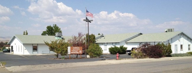
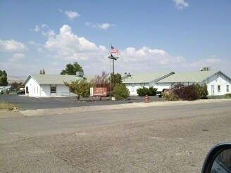
Property Record
2035 Last Chance Rd, Elko, NV 89801

Save to a Folder
{{folder.Name}}
{{folder.ListingIds.length}} Properties
{{folder.ListingIds.length}} Property
Create a New Folder
Property Detail
2035 Last Chance Rd
001-630-033
PARCEL 1 FILE 347195 LOCATED IN MDB&M
Commercialnec
Elko
ZC
Nevada
C and X Area of minimal flood hazard, usually depicted on FIRMs as above the 500-year flood level.
2.50 AC
2024
Carson City/Nevada Area
2025
Other Market Areas
951300
Elko, NV
12,103 SF
NEARBY LISTINGS FOR SALE OR LEASE
DEMOGRAPHICS near 2035 Last Chance Rd
1 mile
3 mile
5 mile
2025 Total Population
5,003
20,935
28,299
2030 Population
5,175
21,350
28,848
Pop Growth 2025-2030
+ 3.44%
+ 1.98%
+ 1.94%
Average Age
34
36
36
2025 Total Households
1,824
8,039
10,739
HH Growth 2025-2030
+ 3.40%
+ 2.02%
+ 1.96%
Median Household Inc
$61,652
$75,664
$79,904
Avg Household Size
2.70
2.50
2.60
2025 Avg HH Vehicles
2.00
2.00
2.00
Median Home Value
$267,607
$297,737
$278,687
Median Year Built
1989
1985
1987
Nearby Places
Map Layers
Map Styles
 Street
 Aerial
Layers
 Traffic
 Biking
Places
Listings with unknown addresses are not visible on the map
- Restaurants
- Banks
- Shops
- Fitness
- Groceries
PUBLIC TRANSPORTATION
COMMUTER RAIL
Drive
Walk
Distance
4 min
1.5 mi
SALE & LEASE HISTORY
LISTING DATE
SALE/LEASE

Dec 05, 2016
For Sale
Nearby Properties
Address
Land Use
TOTAL SIZE
Lot Size
Zoning
Address
Land Use
TOTAL SIZE
Lot Size
Zoning
120,451 SF
45 AC
ZPC
Address
Land Use
TOTAL SIZE
Lot Size
Zoning
47,730 SF
479.29 AC
MULT
Address
Land Use
TOTAL SIZE
Lot Size
Zoning
215,373 SF
14.03 AC
ZPQP
Address
Land Use
TOTAL SIZE
Lot Size
Zoning
14.71 AC
ZLI
Address
Land Use
TOTAL SIZE
Lot Size
Zoning
184,595 SF
10.79 AC
ZR
Address
Land Use
TOTAL SIZE
Lot Size
Zoning
212,789 SF
22.72 AC
ZC
Address
Land Use
TOTAL SIZE
Lot Size
Zoning
23,552 SF
78.93 AC
MULT
Address
Land Use
TOTAL SIZE
Lot Size
Zoning
146,208 SF
36.18 AC
MULT
Address
Land Use
TOTAL SIZE
Lot Size
Zoning
162,124 SF
13.60 AC
ZIBP
Address
Land Use
TOTAL SIZE
Lot Size
Zoning
89,473 SF
10.47 AC
ZC
Address
Land Use
TOTAL SIZE
Lot Size
Zoning
1,253 SF
4 AC
ZR
Address
Land Use
TOTAL SIZE
Lot Size
Zoning
57,884 SF
1.89 AC
ZC
Address
Land Use
TOTAL SIZE
Lot Size
Zoning
54,982 SF
2.17 AC
ZC
Address
Land Use
TOTAL SIZE
Lot Size
Zoning
53,073 SF
2.32 AC
ZC
Address
Land Use
TOTAL SIZE
Lot Size
Zoning
3,234 SF
5.38 AC
ZC
Address
Land Use
TOTAL SIZE
Lot Size
Zoning
59,525 SF
5.91 AC
ZC
Address
Land Use
TOTAL SIZE
Lot Size
Zoning
166,621 SF
1.40 AC
ZC
Address
Land Use
TOTAL SIZE
Lot Size
Zoning
29,193 SF
3.47 AC
ZPQP
Address
Land Use
TOTAL SIZE
Lot Size
Zoning
43,470 SF
1.82 AC
ZC
Address
Land Use
TOTAL SIZE
Lot Size
Zoning
57,628 SF
2.79 AC
ZC
Address
Land Use
TOTAL SIZE
Lot Size
Zoning
53,002 SF
3.11 AC
ZC
Address
Land Use
TOTAL SIZE
Lot Size
Zoning
96,349 SF
6.49 AC
ZC
Address
Land Use
TOTAL SIZE
Lot Size
Zoning
49,124 SF
1.50 AC
ZC
Address
Land Use
TOTAL SIZE
Lot Size
Zoning
32,520 SF
2.29 AC
ZLI
Address
Land Use
TOTAL SIZE
Lot Size
Zoning
36,897 SF
2.57 AC
ZPQP
Address
Land Use
TOTAL SIZE
Lot Size
Zoning
36,717 SF
3.49 AC
ZC
Address
Land Use
TOTAL SIZE
Lot Size
Zoning
98,533 SF
6.66 AC
MULT
Address
Land Use
TOTAL SIZE
Lot Size
Zoning
79,455 SF
9.99 AC
ZC
Address
Land Use
TOTAL SIZE
Lot Size
Zoning
34,972 SF
7.96 AC
ZPQP
Address
Land Use
TOTAL SIZE
Lot Size
Zoning
68,508 SF
7.73 AC
ZC
The World's #1 Commercial Real Estate Marketplace
Connect with us
© 2026 CoStar Group
The information above has been obtained from sources believed reliable. While we do not doubt its accuracy we have not verified it and make no guarantee, warranty or representation about it. It is your responsibility to independently confirm its accuracy and completeness. Any projections, opinions, assumptions, or estimates used are for example only and do not represent the current or future performance of the property. The value of this transaction to you depends on tax and other factors which should be evaluated by your tax, financial, and legal advisors. You and your advisors should conduct a careful, independent investigation of the property to determine to your satisfaction the suitability of the property for your needs.