Property Record
2035 Midway Dr, Twinsburg, OH 44087
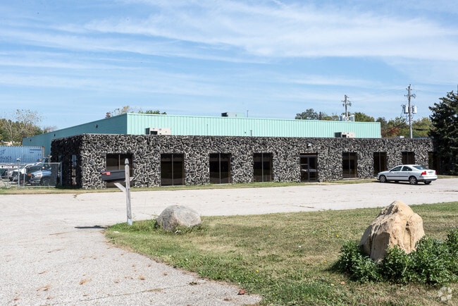


This Property Is For Sale
NEARBY LISTINGS FOR SALE OR LEASE
Property Detail
2035 Midway Dr
Akron, OH
Midway Ind Park
64-03002
MIDWAY IND PK BLK C N OF MIDWAY DR FF 350.00 4.02A
Warehouse
Summit
2023
Ohio
2025
4.02 AC
530103
Twinsburg/Aurora
41,200 SF
Cleveland
DEMOGRAPHICS near 2035 Midway Dr
1 Mile
3 Mile
5 Mile
2024 Total Population
4,207
34,491
86,110
2029 Population
4,146
33,842
84,623
Pop Growth 2024-2029
(1.45%)
(1.88%)
(1.73%)
Average Age
42
43
43
2024 Total Households
1,715
13,374
33,773
HH Growth 2024-2029
(1.40%)
(1.88%)
(1.76%)
Median Household Inc
$69,100
$102,194
$100,622
Avg Household Size
2.40
2.50
2.50
2024 Avg HH Vehicles
2.00
2.00
2.00
Median Home Value
$228,370
$279,099
$282,644
Median Year Built
1983
1990
1986
Nearby Places
Map Layers
Map Styles
 Street
 Aerial
- Restaurants
- Banks
- Shops
- Fitness
- Groceries
PUBLIC TRANSPORTATION
COMMUTER RAIL
Brecksville (National Park Scenic Railway - Cuyahoga Valley Scenic Railroad)
DRIVE
WALK
Distance
Brecksville (National Park Scenic Railway - Cuyahoga Valley Scenic Railroad)
21 min
7.9 mi
AIRPORT
Cleveland-Hopkins International
DRIVE
WALK
Distance
Cleveland-Hopkins International
42 min
29.3 mi
Akron-Canton Regional
DRIVE
WALK
Distance
Akron-Canton Regional
48 min
33.5 mi
Freight Ports
Port of Toledo
DRIVE
WALK
Distance
Port of Toledo
156 min
129.9 mi
Nearby Properties
Address
Land Use
TOTAL SIZE
Lot Size
Zoning
Address
Land Use
TOTAL SIZE
Lot Size
Zoning
Address
Land Use
TOTAL SIZE
Lot Size
Zoning
433,283 SF
29.89 AC
Address
Land Use
TOTAL SIZE
Lot Size
Zoning
315,935 SF
44.94 AC
Address
Land Use
TOTAL SIZE
Lot Size
Zoning
73,902 SF
12.85 AC
Address
Land Use
TOTAL SIZE
Lot Size
Zoning
433,283 SF
40.49 AC
Address
Land Use
TOTAL SIZE
Lot Size
Zoning
325,774 SF
57.80 AC
Address
Land Use
TOTAL SIZE
Lot Size
Zoning
475,568 SF
38.17 AC
IG
Address
Land Use
TOTAL SIZE
Lot Size
Zoning
Address
Land Use
TOTAL SIZE
Lot Size
Zoning
Address
Land Use
TOTAL SIZE
Lot Size
Zoning
300,563 SF
32.51 AC
Address
Land Use
TOTAL SIZE
Lot Size
Zoning
401,401 SF
25.14 AC
IG
Address
Land Use
TOTAL SIZE
Lot Size
Zoning
270,968 SF
21.68 AC
Address
Land Use
TOTAL SIZE
Lot Size
Zoning
230,501 SF
39.59 AC
Address
Land Use
TOTAL SIZE
Lot Size
Zoning
155,897 SF
19.81 AC
Address
Land Use
TOTAL SIZE
Lot Size
Zoning
254,828 SF
15.41 AC
Address
Land Use
TOTAL SIZE
Lot Size
Zoning
60,305 SF
57.84 AC
Address
Land Use
TOTAL SIZE
Lot Size
Zoning
342,068 SF
29.02 AC
Address
Land Use
TOTAL SIZE
Lot Size
Zoning
418,992 SF
27.87 AC
Address
Land Use
TOTAL SIZE
Lot Size
Zoning
290,113 SF
15.05 AC
Address
Land Use
TOTAL SIZE
Lot Size
Zoning
Address
Land Use
TOTAL SIZE
Lot Size
Zoning
353,200 SF
25.60 AC
Address
Land Use
TOTAL SIZE
Lot Size
Zoning
111,145 SF
39.21 AC
Address
Land Use
TOTAL SIZE
Lot Size
Zoning
Address
Land Use
TOTAL SIZE
Lot Size
Zoning
136,800 SF
7.86 AC
Address
Land Use
TOTAL SIZE
Lot Size
Zoning
235,200 SF
19.57 AC
Address
Land Use
TOTAL SIZE
Lot Size
Zoning
300,900 SF
10.39 AC
Address
Land Use
TOTAL SIZE
Lot Size
Zoning
204,490 SF
14.52 AC
Address
Land Use
TOTAL SIZE
Lot Size
Zoning
137,743 SF
28.51 AC
Address
Land Use
TOTAL SIZE
Lot Size
Zoning
99,400 SF
3.96 AC
Address
Land Use
TOTAL SIZE
Lot Size
Zoning
85,808 SF
10.20 AC
The World's #1 Commercial Real Estate Marketplace
Connect with us
© 2025 CoStar Group
The information above has been obtained from sources believed reliable. While we do not doubt its accuracy we have not verified it and make no guarantee, warranty or representation about it. It is your responsibility to independently confirm its accuracy and completeness. Any projections, opinions, assumptions, or estimates used are for example only and do not represent the current or future performance of the property. The value of this transaction to you depends on tax and other factors which should be evaluated by your tax, financial, and legal advisors. You and your advisors should conduct a careful, independent investigation of the property to determine to your satisfaction the suitability of the property for your needs.