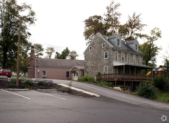
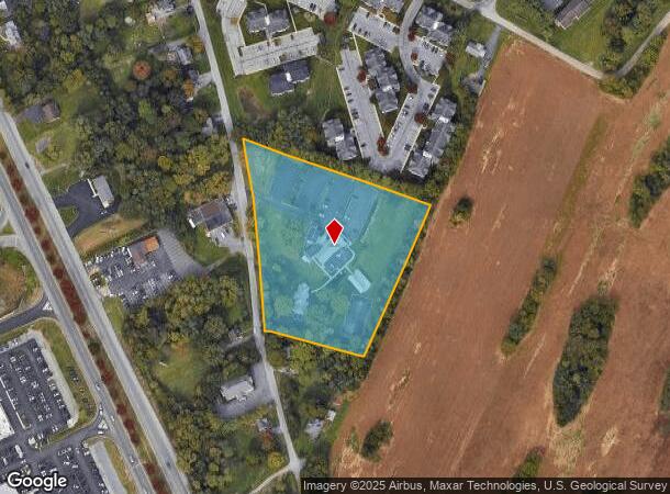
Property Record
2036 Day Rd, Hagerstown, MD 21740
NEARBY LISTINGS FOR SALE OR LEASE
Property Detail
2036 Day Rd
10-015510
Mosque Worship
Religious
LOT 346X476 4.46 AC 2036 DAY ROAD MOSQUE WORSHIP
X
Washington
24043C0306D
Maryland
0
4.46 AC
2025
Washington County
011100
Washington, DC
1,944 SF
Hagerstown-Martinsburg, MD-WV
DEMOGRAPHICS near 2036 Day Rd
1 mile
3 mile
5 mile
2024 Total Population
3,313
29,801
80,735
2029 Population
3,345
30,237
81,895
Pop Growth 2024-2029
+ 0.97%
+ 1.46%
+ 1.44%
Average Age
44
41
40
2024 Total Households
1,480
12,092
32,352
HH Growth 2024-2029
+ 0.95%
+ 1.48%
+ 1.47%
Median Household Inc
$52,200
$59,182
$55,942
Avg Household Size
2.20
2.40
2.40
2024 Avg HH Vehicles
2.00
2.00
2.00
Median Home Value
$251,799
$228,056
$213,267
Median Year Built
1983
1981
1969
Nearby Places
Map Layers
Map Styles
 Street
 Aerial
Transit
 Traffic
 Biking
Places
Listings with unknown addresses are not visible on the map
- Restaurants
- Banks
- Shops
- Fitness
- Groceries
PUBLIC TRANSPORTATION
AIRPORT
Hagerstown Regional/Richard A Henson Field
Drive
Walk
Distance
Hagerstown Regional/Richard A Henson Field
17 min
8.2 mi
Freight Ports
Port of Baltimore
Drive
Walk
Distance
Port of Baltimore
88 min
73.1 mi
Nearby Properties
Address
Land Use
TOTAL SIZE
Lot Size
Zoning
Address
Land Use
TOTAL SIZE
Lot Size
Zoning
502,262 SF
36.64 AC
ORI
Address
Land Use
TOTAL SIZE
Lot Size
Zoning
1,236,085 SF
134.31 AC
IMU
Address
Land Use
TOTAL SIZE
Lot Size
Zoning
77,027 SF
310.67 AC
ERT
Address
Land Use
TOTAL SIZE
Lot Size
Zoning
103,131 SF
53.74 AC
RMOD
Address
Land Use
TOTAL SIZE
Lot Size
Zoning
200,815 SF
9.14 AC
ORI
Address
Land Use
TOTAL SIZE
Lot Size
Zoning
167,084 SF
64.62 AC
RMOD
Address
Land Use
TOTAL SIZE
Lot Size
Zoning
77,934 SF
12.79 AC
RMED
Address
Land Use
TOTAL SIZE
Lot Size
Zoning
290,600 SF
51.35 AC
IMU
Address
Land Use
TOTAL SIZE
Lot Size
Zoning
52,259 SF
60.86 AC
HI
Address
Land Use
TOTAL SIZE
Lot Size
Zoning
7,427 SF
79.25 AC
RS
Address
Land Use
TOTAL SIZE
Lot Size
Zoning
94,185 SF
9.25 AC
RMED
Address
Land Use
TOTAL SIZE
Lot Size
Zoning
88,116 SF
18.44 AC
RMOD
Address
Land Use
TOTAL SIZE
Lot Size
Zoning
67,434 SF
4.30 AC
RS
Address
Land Use
TOTAL SIZE
Lot Size
Zoning
80,816 SF
19.68 AC
ORI
Address
Land Use
TOTAL SIZE
Lot Size
Zoning
198 SF
7.04 AC
RH
Address
Land Use
TOTAL SIZE
Lot Size
Zoning
8,546 SF
4 AC
IG
Address
Land Use
TOTAL SIZE
Lot Size
Zoning
54,843 SF
3.08 AC
POM
Address
Land Use
TOTAL SIZE
Lot Size
Zoning
138,132 SF
22.90 AC
HI
Address
Land Use
TOTAL SIZE
Lot Size
Zoning
28,584 SF
4.13 AC
HI
Address
Land Use
TOTAL SIZE
Lot Size
Zoning
1,516 SF
9.39 AC
CG
Address
Land Use
TOTAL SIZE
Lot Size
Zoning
29,405 SF
29.47 AC
RH
Address
Land Use
TOTAL SIZE
Lot Size
Zoning
4,180 SF
244.75 AC
RT
Address
Land Use
TOTAL SIZE
Lot Size
Zoning
52,443 SF
2.19 AC
RH
Address
Land Use
TOTAL SIZE
Lot Size
Zoning
61,343 SF
3.73 AC
CG
Address
Land Use
TOTAL SIZE
Lot Size
Zoning
9.86 AC
CR
Address
Land Use
TOTAL SIZE
Lot Size
Zoning
154 SF
3.79 AC
RH
Address
Land Use
TOTAL SIZE
Lot Size
Zoning
8.01 AC
RS-PU
Address
Land Use
TOTAL SIZE
Lot Size
Zoning
45,305 SF
5.17 AC
RS-PU
Address
Land Use
TOTAL SIZE
Lot Size
Zoning
10,659 SF
142.91 AC
IR
Address
Land Use
TOTAL SIZE
Lot Size
Zoning
18,228 SF
7.75 AC
RS-PU
The World's #1 Commercial Real Estate Marketplace
Connect with us
© 2026 CoStar Group
The information above has been obtained from sources believed reliable. While we do not doubt its accuracy we have not verified it and make no guarantee, warranty or representation about it. It is your responsibility to independently confirm its accuracy and completeness. Any projections, opinions, assumptions, or estimates used are for example only and do not represent the current or future performance of the property. The value of this transaction to you depends on tax and other factors which should be evaluated by your tax, financial, and legal advisors. You and your advisors should conduct a careful, independent investigation of the property to determine to your satisfaction the suitability of the property for your needs.