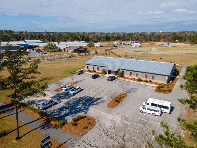
Property Record
2037 E Park Ave, Valdosta, GA 31602


NEARBY LISTINGS FOR SALE OR LEASE
Property Detail
2037 E Park Ave
0151D-049
North Acreage "2"
Gymhealthspa
TRACT 1_4.0 ACRES_PCB 1320
AE
Lowndes
13101C0025A
Georgia
2024
4 AC
2024
Valdosta/Lake Park
010604
Other Market Areas
11,250 SF
Valdosta, GA
DEMOGRAPHICS near 2037 E Park Ave
1 Mile
3 Mile
5 Mile
2024 Total Population
3,541
37,980
69,308
2029 Population
3,675
39,434
71,997
Pop Growth 2024-2029
+ 3.78%
+ 3.83%
+ 3.88%
Average Age
33
34
35
2024 Total Households
1,305
14,721
27,062
HH Growth 2024-2029
+ 3.83%
+ 4.02%
+ 4.05%
Median Household Inc
$32,933
$30,751
$34,478
Avg Household Size
2.60
2.40
2.40
2024 Avg HH Vehicles
2.00
1.00
2.00
Median Home Value
$61,988
$128,288
$160,926
Median Year Built
1991
1987
1989
Nearby Places
Map Layers
Map Styles
 Street
 Aerial
- Restaurants
- Banks
- Shops
- Fitness
- Groceries
PUBLIC TRANSPORTATION
AIRPORT
Valdosta Regional
DRIVE
WALK
Distance
Valdosta Regional
13 min
6.9 mi
Freight Ports
Jacksonville Port
DRIVE
WALK
Distance
Jacksonville Port
150 min
129.1 mi
SALE & LEASE HISTORY
LISTING DATE
SALE/LEASE

Feb 10, 2023
For Sale
Nearby Properties
Address
Land Use
TOTAL SIZE
Lot Size
Zoning
Address
Land Use
TOTAL SIZE
Lot Size
Zoning
60,000 SF
56.32 AC
M-1
Address
Land Use
TOTAL SIZE
Lot Size
Zoning
39,024 SF
18.04 AC
P-D
Address
Land Use
TOTAL SIZE
Lot Size
Zoning
4,878 SF
14.83 AC
R-P
Address
Land Use
TOTAL SIZE
Lot Size
Zoning
210,020 SF
4.22 AC
C-C
Address
Land Use
TOTAL SIZE
Lot Size
Zoning
15.75 AC
R-P
Address
Land Use
TOTAL SIZE
Lot Size
Zoning
339 SF
23.53 AC
E-R
Address
Land Use
TOTAL SIZE
Lot Size
Zoning
19,825 SF
16.93 AC
R-M
Address
Land Use
TOTAL SIZE
Lot Size
Zoning
2,574 SF
12 AC
R-P
Address
Land Use
TOTAL SIZE
Lot Size
Zoning
185,727 SF
20.33 AC
C-H
Address
Land Use
TOTAL SIZE
Lot Size
Zoning
114,922 SF
11.38 AC
C-C
Address
Land Use
TOTAL SIZE
Lot Size
Zoning
142,140 SF
24.29 AC
DR-10
Address
Land Use
TOTAL SIZE
Lot Size
Zoning
24,928 SF
10 AC
R-M
Address
Land Use
TOTAL SIZE
Lot Size
Zoning
65,664 SF
16.06 AC
R-M
Address
Land Use
TOTAL SIZE
Lot Size
Zoning
7,200 SF
9.92 AC
M-1
Address
Land Use
TOTAL SIZE
Lot Size
Zoning
40,800 SF
5.83 AC
R-P
Address
Land Use
TOTAL SIZE
Lot Size
Zoning
53,880 SF
8.01 AC
C-H,C-C
Address
Land Use
TOTAL SIZE
Lot Size
Zoning
93,032 SF
2.80 AC
C-H
Address
Land Use
TOTAL SIZE
Lot Size
Zoning
78,048 SF
9.18 AC
R-P
Address
Land Use
TOTAL SIZE
Lot Size
Zoning
13,056 SF
9.41 AC
R-M
Address
Land Use
TOTAL SIZE
Lot Size
Zoning
1,902 SF
10.58 AC
R-M
Address
Land Use
TOTAL SIZE
Lot Size
Zoning
166,300 SF
43.05 AC
M-2
Address
Land Use
TOTAL SIZE
Lot Size
Zoning
48,000 SF
9.06 AC
C-C
Address
Land Use
TOTAL SIZE
Lot Size
Zoning
110,646 SF
9.76 AC
R-P
Address
Land Use
TOTAL SIZE
Lot Size
Zoning
100,000 SF
25.27 AC
M-1
Address
Land Use
TOTAL SIZE
Lot Size
Zoning
49,546 SF
10.45 AC
R-P
Address
Land Use
TOTAL SIZE
Lot Size
Zoning
202,062 SF
7.12 AC
R-15
Address
Land Use
TOTAL SIZE
Lot Size
Zoning
25,727 SF
9.12 AC
R-A
Address
Land Use
TOTAL SIZE
Lot Size
Zoning
103,468 SF
9.38 AC
C-H
Address
Land Use
TOTAL SIZE
Lot Size
Zoning
9,180 SF
4.86 AC
C-H
Address
Land Use
TOTAL SIZE
Lot Size
Zoning
9,000 SF
72.18 AC
E-A
The World's #1 Commercial Real Estate Marketplace
Connect with us
© 2025 CoStar Group
The information above has been obtained from sources believed reliable. While we do not doubt its accuracy we have not verified it and make no guarantee, warranty or representation about it. It is your responsibility to independently confirm its accuracy and completeness. Any projections, opinions, assumptions, or estimates used are for example only and do not represent the current or future performance of the property. The value of this transaction to you depends on tax and other factors which should be evaluated by your tax, financial, and legal advisors. You and your advisors should conduct a careful, independent investigation of the property to determine to your satisfaction the suitability of the property for your needs.