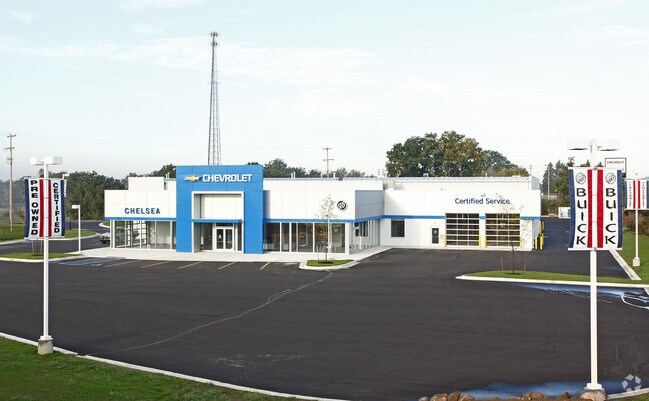
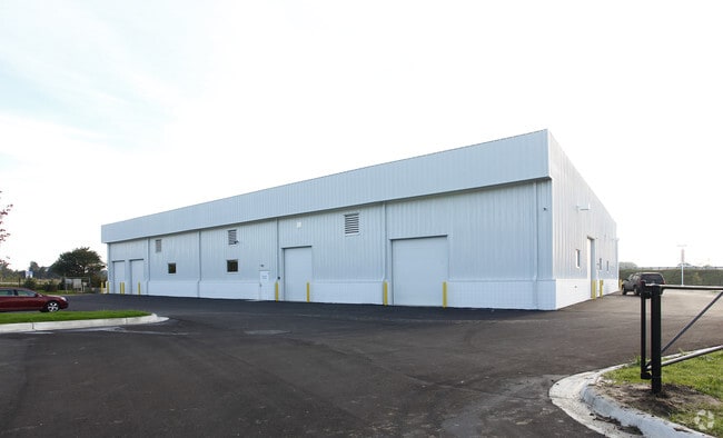
Property Record
2038 S Mckernan Rd, Chelsea, MI 48118

NEARBY LISTINGS FOR SALE OR LEASE
Property Detail
2038 S Mckernan Rd
06-24-200-002
BNDRY ADJST PER SURVEY 12/12/2020 OWNER REQUEST SY 24-3E-2 PCL S COM AT NW COR SEC 24
Commercialnec
Washtenaw
X
Michigan
26161C0192E
7.29 AC
2025
Washtenaw W of 23
2025
Detroit
447000
Ann Arbor, MI
24,756 SF
DEMOGRAPHICS near 2038 S Mckernan Rd
1 Mile
3 Mile
5 Mile
2024 Total Population
922
8,243
12,295
2029 Population
910
8,187
12,209
Pop Growth 2024-2029
(1.30%)
(0.68%)
(0.70%)
Average Age
48
46
45
2024 Total Households
404
3,445
4,900
HH Growth 2024-2029
(0.99%)
(0.58%)
(0.63%)
Median Household Inc
$67,702
$72,942
$84,308
Avg Household Size
2.20
2.30
2.40
2024 Avg HH Vehicles
2.00
2.00
2.00
Median Home Value
$316,990
$306,499
$334,229
Median Year Built
1993
1984
1985
Nearby Places
Map Layers
Map Styles
 Street
 Aerial
- Restaurants
- Banks
- Shops
- Fitness
- Groceries
Nearby Properties
Address
Land Use
TOTAL SIZE
Lot Size
Zoning
Address
Land Use
TOTAL SIZE
Lot Size
Zoning
640,510 SF
3,457 AC
I-ART
Address
Land Use
TOTAL SIZE
Lot Size
Zoning
62,862 SF
21.22 AC
MC MEDI
Address
Land Use
TOTAL SIZE
Lot Size
Zoning
162,593 SF
20.44 AC
MC MEDI
Address
Land Use
TOTAL SIZE
Lot Size
Zoning
45,458 SF
31.45 AC
MC MEDI
Address
Land Use
TOTAL SIZE
Lot Size
Zoning
122,580 SF
8.16 AC
I-1 IN
Address
Land Use
TOTAL SIZE
Lot Size
Zoning
6,483 SF
5.33 AC
RS2 SI
Address
Land Use
TOTAL SIZE
Lot Size
Zoning
73,940 SF
7.35 AC
C4 REST
Address
Land Use
TOTAL SIZE
Lot Size
Zoning
188,847 SF
30.13 AC
I-1 IN
Address
Land Use
TOTAL SIZE
Lot Size
Zoning
97,673 SF
8.79 AC
C4 REST
Address
Land Use
TOTAL SIZE
Lot Size
Zoning
49,836 SF
7.19 AC
PMU PLA
Address
Land Use
TOTAL SIZE
Lot Size
Zoning
60,150 SF
7.12 AC
I-2 LIG
Address
Land Use
TOTAL SIZE
Lot Size
Zoning
151.36 AC
Address
Land Use
TOTAL SIZE
Lot Size
Zoning
23,354 SF
129.71 AC
AG
Address
Land Use
TOTAL SIZE
Lot Size
Zoning
17,522 SF
2.38 AC
C4 REST
Address
Land Use
TOTAL SIZE
Lot Size
Zoning
73,356 SF
9.29 AC
C2 GEN
Address
Land Use
TOTAL SIZE
Lot Size
Zoning
35,200 SF
2.69 AC
I-2 LIG
Address
Land Use
TOTAL SIZE
Lot Size
Zoning
27,416 SF
16.26 AC
C2 GEN
Address
Land Use
TOTAL SIZE
Lot Size
Zoning
8,584 SF
3.11 AC
RM2 MU
Address
Land Use
TOTAL SIZE
Lot Size
Zoning
22,578 SF
4.64 AC
C4 REST
Address
Land Use
TOTAL SIZE
Lot Size
Zoning
41,267 SF
1.90 AC
C3 HIG
Address
Land Use
TOTAL SIZE
Lot Size
Zoning
55,736 SF
1 AC
C5 CENT
Address
Land Use
TOTAL SIZE
Lot Size
Zoning
32,002 SF
2.32 AC
C3 HIG
Address
Land Use
TOTAL SIZE
Lot Size
Zoning
62,098 SF
4.38 AC
I-1 IN
Address
Land Use
TOTAL SIZE
Lot Size
Zoning
42,297 SF
3.97 AC
I-2 LIG
Address
Land Use
TOTAL SIZE
Lot Size
Zoning
40,600 SF
2.14 AC
I-2 LIG
Address
Land Use
TOTAL SIZE
Lot Size
Zoning
27,410 SF
1 AC
C5 CENT
Address
Land Use
TOTAL SIZE
Lot Size
Zoning
2,415 SF
2.88 AC
RM2 MU
Address
Land Use
TOTAL SIZE
Lot Size
Zoning
31,572 SF
1 AC
C5 CENT
Address
Land Use
TOTAL SIZE
Lot Size
Zoning
114,991 SF
8.70 AC
I-2 LIG
The World's #1 Commercial Real Estate Marketplace
Connect with us
© 2026 CoStar Group
The information above has been obtained from sources believed reliable. While we do not doubt its accuracy we have not verified it and make no guarantee, warranty or representation about it. It is your responsibility to independently confirm its accuracy and completeness. Any projections, opinions, assumptions, or estimates used are for example only and do not represent the current or future performance of the property. The value of this transaction to you depends on tax and other factors which should be evaluated by your tax, financial, and legal advisors. You and your advisors should conduct a careful, independent investigation of the property to determine to your satisfaction the suitability of the property for your needs.