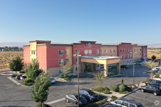
Property Record
2038 W Avenue I, Lancaster, CA 93536


NEARBY LISTINGS FOR SALE OR LEASE
-
-
View all Lancaster listings for sale on LoopNet.com
Property Detail
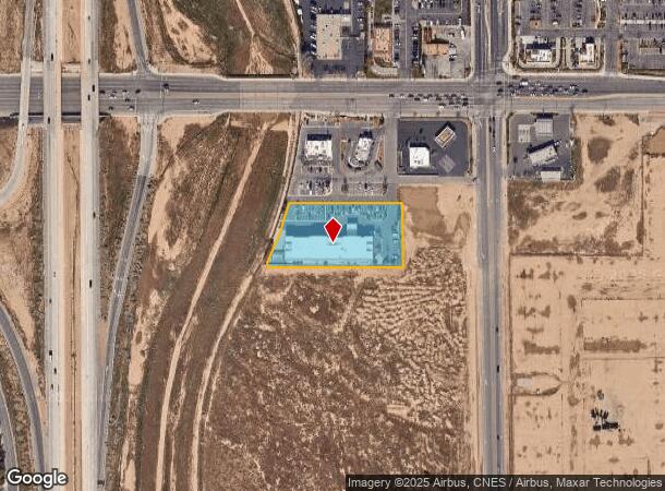
2038 W Avenue I
Los Angeles-Long Beach-Glendale, CA
Parcel Map 64924
3121-034-043
PM 375-68-70 LOT 3
Motel
Los Angeles
X
California
06037C0410F
3
2024
1.62 AC
2025
Los Angeles North
900508
Los Angeles
49,891 SF
DEMOGRAPHICS near 2038 W Avenue I
1 Mile
3 Mile
5 Mile
2024 Total Population
12,436
84,693
155,885
2029 Population
11,992
82,294
151,394
Pop Growth 2024-2029
(3.57%)
(2.83%)
(2.88%)
Average Age
37
37
37
2024 Total Households
3,757
28,346
49,561
HH Growth 2024-2029
(3.86%)
(3.01%)
(3.09%)
Median Household Inc
$70,425
$59,210
$62,103
Avg Household Size
3.20
2.90
3.00
2024 Avg HH Vehicles
2.00
2.00
2.00
Median Home Value
$299,999
$323,206
$319,208
Median Year Built
1983
1983
1984
Nearby Places
Map Layers
Map Styles
 Street
 Aerial
- Restaurants
- Banks
- Shops
- Fitness
- Groceries
PUBLIC TRANSPORTATION
COMMUTER RAIL
Lancaster (Antelope Valley Line - Southern California Regional Rail Authority (Metrolink))
DRIVE
WALK
Distance
Lancaster (Antelope Valley Line - Southern California Regional Rail Authority (Metrolink))
4 min
2.3 mi
Freight Ports
Port of Long Beach
DRIVE
WALK
Distance
Port of Long Beach
111 min
94.5 mi
SALE & LEASE HISTORY
LISTING DATE
SALE/LEASE

Nov 10, 2016
For Sale
Nearby Properties
Address
Land Use
TOTAL SIZE
Lot Size
Zoning
Address
Land Use
TOTAL SIZE
Lot Size
Zoning
2,922,905 SF
85.01 AC
LRLI
Address
Land Use
TOTAL SIZE
Lot Size
Zoning
234,378 SF
15.25 AC
Address
Land Use
TOTAL SIZE
Lot Size
Zoning
143,852 SF
8.58 AC
LRHDR*
Address
Land Use
TOTAL SIZE
Lot Size
Zoning
153,117 SF
14.12 AC
LRSP80-01*
Address
Land Use
TOTAL SIZE
Lot Size
Zoning
160,028 SF
10.81 AC
LRMDR*
Address
Land Use
TOTAL SIZE
Lot Size
Zoning
179,304 SF
12.43 AC
LRMDR*
Address
Land Use
TOTAL SIZE
Lot Size
Zoning
126,102 SF
8.57 AC
LRRA7000*
Address
Land Use
TOTAL SIZE
Lot Size
Zoning
552,178 SF
17.77 AC
LRHI*
Address
Land Use
TOTAL SIZE
Lot Size
Zoning
212,198 SF
18.27 AC
LRSP80-01*
Address
Land Use
TOTAL SIZE
Lot Size
Zoning
129,896 SF
9.10 AC
LRRPD70001
Address
Land Use
TOTAL SIZE
Lot Size
Zoning
465,697 SF
27.82 AC
LRSP*
Address
Land Use
TOTAL SIZE
Lot Size
Zoning
74,213 SF
4.46 AC
LRA17000*
Address
Land Use
TOTAL SIZE
Lot Size
Zoning
185,527 SF
9.65 AC
LRR325U*
Address
Land Use
TOTAL SIZE
Lot Size
Zoning
60,113 SF
2.03 AC
LRCPD
Address
Land Use
TOTAL SIZE
Lot Size
Zoning
89,351 SF
17.97 AC
LRMDR
Address
Land Use
TOTAL SIZE
Lot Size
Zoning
123,924 SF
19.01 AC
LRA22*
Address
Land Use
TOTAL SIZE
Lot Size
Zoning
166,272 SF
8.71 AC
LRRA7000*
Address
Land Use
TOTAL SIZE
Lot Size
Zoning
132,584 SF
8.66 AC
LRMDR*
Address
Land Use
TOTAL SIZE
Lot Size
Zoning
170,697 SF
9.29 AC
LRRPD12U*
Address
Land Use
TOTAL SIZE
Lot Size
Zoning
90,429 SF
4.59 AC
LRHDR*
Address
Land Use
TOTAL SIZE
Lot Size
Zoning
90,429 SF
4.38 AC
LRHDR*
Address
Land Use
TOTAL SIZE
Lot Size
Zoning
214,178 SF
13.95 AC
LRRA7000*
Address
Land Use
TOTAL SIZE
Lot Size
Zoning
145,593 SF
5.18 AC
LRC3*
Address
Land Use
TOTAL SIZE
Lot Size
Zoning
76,093 SF
1.37 AC
LRC3*
Address
Land Use
TOTAL SIZE
Lot Size
Zoning
97,566 SF
8.81 AC
LRC3*
Address
Land Use
TOTAL SIZE
Lot Size
Zoning
73,248 SF
3.56 AC
LRR325UDP*
Address
Land Use
TOTAL SIZE
Lot Size
Zoning
107,924 SF
8.95 AC
LRRPD10000
Address
Land Use
TOTAL SIZE
Lot Size
Zoning
127,975 SF
4.77 AC
LRC3DP*
Address
Land Use
TOTAL SIZE
Lot Size
Zoning
70,456 SF
3.05 AC
LRRC
Address
Land Use
TOTAL SIZE
Lot Size
Zoning
183,296 SF
11.75 AC
LRRPD25U*
The World's #1 Commercial Real Estate Marketplace
Connect with us
© 2025 CoStar Group
The information above has been obtained from sources believed reliable. While we do not doubt its accuracy we have not verified it and make no guarantee, warranty or representation about it. It is your responsibility to independently confirm its accuracy and completeness. Any projections, opinions, assumptions, or estimates used are for example only and do not represent the current or future performance of the property. The value of this transaction to you depends on tax and other factors which should be evaluated by your tax, financial, and legal advisors. You and your advisors should conduct a careful, independent investigation of the property to determine to your satisfaction the suitability of the property for your needs.