Property Record
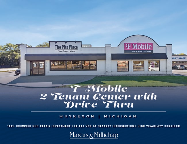
2039 E Apple Ave, Muskegon, MI 49442


NEARBY LISTINGS FOR SALE OR LEASE
Property Detail
2039 E Apple Ave
Muskegon, MI
Home Gardens
10-400-000-0002-00
MUSKEGON CHARTER TOWNSHIP SEC 27 T10N R16W HG-1966 HOME GARDENS N 1/2 OF LOT 2
Commercialnec
Muskegon
X
Michigan
26121C0277D
2
2024
1.19 AC
2025
Eastern Muskegon County
001902
West Michigan
4,848 SF
DEMOGRAPHICS near 2039 E Apple Ave
1 Mile
3 Mile
5 Mile
2024 Total Population
9,083
46,473
95,048
2029 Population
9,119
46,942
95,818
Pop Growth 2024-2029
+ 0.40%
+ 1.01%
+ 0.81%
Average Age
41
39
39
2024 Total Households
4,119
17,066
36,758
HH Growth 2024-2029
+ 0.41%
+ 1.01%
+ 0.80%
Median Household Inc
$39,356
$38,984
$46,595
Avg Household Size
2.10
2.40
2.40
2024 Avg HH Vehicles
1.00
1.00
2.00
Median Home Value
$119,441
$88,362
$122,321
Median Year Built
1970
1958
1961
Nearby Places
Map Layers
Map Styles
 Street
 Aerial
- Restaurants
- Banks
- Shops
- Fitness
- Groceries
SALE & LEASE HISTORY
LISTING DATE
SALE/LEASE

Sep 13, 2019
For Sale
Oct 30, 2017
For Sale
Oct 25, 2022
For Sale
Feb 16, 2022
For Sale
Feb 03, 2017
For Lease
Nearby Properties
Address
Land Use
TOTAL SIZE
Lot Size
Zoning
Address
Land Use
TOTAL SIZE
Lot Size
Zoning
490,693 SF
22.70 AC
Address
Land Use
TOTAL SIZE
Lot Size
Zoning
82,643 SF
5.20 AC
MC
Address
Land Use
TOTAL SIZE
Lot Size
Zoning
129,264 SF
R
Address
Land Use
TOTAL SIZE
Lot Size
Zoning
446,688 SF
29.50 AC
RM-2
Address
Land Use
TOTAL SIZE
Lot Size
Zoning
892,516 SF
57.88 AC
I
Address
Land Use
TOTAL SIZE
Lot Size
Zoning
223,802 SF
22.02 AC
SC-1
Address
Land Use
TOTAL SIZE
Lot Size
Zoning
79,321 SF
4.28 AC
B-3
Address
Land Use
TOTAL SIZE
Lot Size
Zoning
271,435 SF
13.80 AC
I-2
Address
Land Use
TOTAL SIZE
Lot Size
Zoning
116,657 SF
1.60 AC
FBC-UR
Address
Land Use
TOTAL SIZE
Lot Size
Zoning
79,321 SF
5 AC
FBC-MS
Address
Land Use
TOTAL SIZE
Lot Size
Zoning
80,572 SF
12.98 AC
I-1
Address
Land Use
TOTAL SIZE
Lot Size
Zoning
2,466 SF
95.29 AC
RMH
Address
Land Use
TOTAL SIZE
Lot Size
Zoning
19,171 SF
6.55 AC
MC
Address
Land Use
TOTAL SIZE
Lot Size
Zoning
71,329 SF
I-2
Address
Land Use
TOTAL SIZE
Lot Size
Zoning
2,044 SF
4.10 AC
RT
Address
Land Use
TOTAL SIZE
Lot Size
Zoning
82,895 SF
13.09 AC
SC-1
Address
Land Use
TOTAL SIZE
Lot Size
Zoning
85,577 SF
8.72 AC
PUD
Address
Land Use
TOTAL SIZE
Lot Size
Zoning
163,658 SF
14.70 AC
RM-1
Address
Land Use
TOTAL SIZE
Lot Size
Zoning
33,750 SF
R
Address
Land Use
TOTAL SIZE
Lot Size
Zoning
241,589 SF
14.60 AC
I-2
Address
Land Use
TOTAL SIZE
Lot Size
Zoning
180,144 SF
3.29 AC
RM-1
Address
Land Use
TOTAL SIZE
Lot Size
Zoning
121,466 SF
11.65 AC
SC-1
Address
Land Use
TOTAL SIZE
Lot Size
Zoning
143,193 SF
13.82 AC
SC-1
Address
Land Use
TOTAL SIZE
Lot Size
Zoning
60,658 SF
4.42 AC
RM-2
Address
Land Use
TOTAL SIZE
Lot Size
Zoning
80,572 SF
12.98 AC
I-1
Address
Land Use
TOTAL SIZE
Lot Size
Zoning
17,461 SF
2.72 AC
MC
Address
Land Use
TOTAL SIZE
Lot Size
Zoning
179,172 SF
20.72 AC
I-2
Address
Land Use
TOTAL SIZE
Lot Size
Zoning
42,888 SF
2.10 AC
R
Address
Land Use
TOTAL SIZE
Lot Size
Zoning
118,555 SF
12.11 AC
R3
Address
Land Use
TOTAL SIZE
Lot Size
Zoning
162,949 SF
7.36 AC
I-2
The World's #1 Commercial Real Estate Marketplace
Connect with us
© 2026 CoStar Group
The information above has been obtained from sources believed reliable. While we do not doubt its accuracy we have not verified it and make no guarantee, warranty or representation about it. It is your responsibility to independently confirm its accuracy and completeness. Any projections, opinions, assumptions, or estimates used are for example only and do not represent the current or future performance of the property. The value of this transaction to you depends on tax and other factors which should be evaluated by your tax, financial, and legal advisors. You and your advisors should conduct a careful, independent investigation of the property to determine to your satisfaction the suitability of the property for your needs.