Property Record
2039 S 6Th St, Indiana, PA 15701


NEARBY LISTINGS FOR SALE OR LEASE
-
-
View all Indiana listings for sale on LoopNet.com
Property Detail
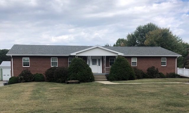
2039 S 6Th St
42-024-109.02
AC= 4.02 1 CB 1 GA 1 DR
Officebuilding
Indiana
X
Pennsylvania
42063C0384F
4.02 AC
2025
Pennsylvania Central Area
2025
Other Market Areas
960800
Indiana, PA
2,628 SF
DEMOGRAPHICS near 2039 S 6Th St
1 Mile
3 Mile
5 Mile
2024 Total Population
876
9,446
35,092
2029 Population
870
9,407
35,095
Pop Growth 2024-2029
(0.68%)
(0.41%)
+ 0.01%
Average Age
48
39
39
2024 Total Households
323
3,510
13,568
HH Growth 2024-2029
(0.93%)
(0.51%)
(0.01%)
Median Household Inc
$106,250
$52,861
$50,018
Avg Household Size
2.40
2.20
2.10
2024 Avg HH Vehicles
2.00
2.00
2.00
Median Home Value
$226,437
$149,690
$152,054
Median Year Built
1986
1965
1970
Nearby Places
Map Layers
Map Styles
 Street
 Aerial
- Restaurants
- Banks
- Shops
- Fitness
- Groceries
PUBLIC TRANSPORTATION
AIRPORT
Arnold Palmer Regional
DRIVE
WALK
Distance
Arnold Palmer Regional
49 min
30.5 mi
SALE & LEASE HISTORY
LISTING DATE
SALE/LEASE

Oct 26, 2020
For Sale
Nearby Properties
Address
Land Use
TOTAL SIZE
Lot Size
Zoning
Address
Land Use
TOTAL SIZE
Lot Size
Zoning
68,928 SF
7.83 AC
Address
Land Use
TOTAL SIZE
Lot Size
Zoning
92,892 SF
60.52 AC
Address
Land Use
TOTAL SIZE
Lot Size
Zoning
70,284 SF
28.33 AC
Address
Land Use
TOTAL SIZE
Lot Size
Zoning
41,436 SF
10.80 AC
Address
Land Use
TOTAL SIZE
Lot Size
Zoning
38,440 SF
2.06 AC
Address
Land Use
TOTAL SIZE
Lot Size
Zoning
81,431 SF
5.68 AC
Address
Land Use
TOTAL SIZE
Lot Size
Zoning
57,760 SF
1.43 AC
Address
Land Use
TOTAL SIZE
Lot Size
Zoning
9,180 SF
22.93 AC
Address
Land Use
TOTAL SIZE
Lot Size
Zoning
28,812 SF
2.48 AC
Address
Land Use
TOTAL SIZE
Lot Size
Zoning
28,743 SF
1.66 AC
Address
Land Use
TOTAL SIZE
Lot Size
Zoning
72,606 SF
17.50 AC
Address
Land Use
TOTAL SIZE
Lot Size
Zoning
76,806 SF
Address
Land Use
TOTAL SIZE
Lot Size
Zoning
59,793 SF
5.29 AC
Address
Land Use
TOTAL SIZE
Lot Size
Zoning
3,080 SF
1.30 AC
Address
Land Use
TOTAL SIZE
Lot Size
Zoning
46,378 SF
1.97 AC
Address
Land Use
TOTAL SIZE
Lot Size
Zoning
37,404 SF
13.17 AC
Address
Land Use
TOTAL SIZE
Lot Size
Zoning
42,003 SF
Address
Land Use
TOTAL SIZE
Lot Size
Zoning
57.15 AC
Address
Land Use
TOTAL SIZE
Lot Size
Zoning
330 SF
Address
Land Use
TOTAL SIZE
Lot Size
Zoning
47,967 SF
4.18 AC
Address
Land Use
TOTAL SIZE
Lot Size
Zoning
87,360 SF
Address
Land Use
TOTAL SIZE
Lot Size
Zoning
9.39 AC
Address
Land Use
TOTAL SIZE
Lot Size
Zoning
27,792 SF
0.37 AC
Address
Land Use
TOTAL SIZE
Lot Size
Zoning
31,014 SF
20.92 AC
Address
Land Use
TOTAL SIZE
Lot Size
Zoning
1,600 SF
9.39 AC
Address
Land Use
TOTAL SIZE
Lot Size
Zoning
8,778 SF
1.96 AC
Address
Land Use
TOTAL SIZE
Lot Size
Zoning
7,920 SF
36.17 AC
Address
Land Use
TOTAL SIZE
Lot Size
Zoning
12,164 SF
17.19 AC
Address
Land Use
TOTAL SIZE
Lot Size
Zoning
132,006 SF
5.86 AC
Address
Land Use
TOTAL SIZE
Lot Size
Zoning
46,046 SF
6.22 AC
The World's #1 Commercial Real Estate Marketplace
Connect with us
© 2026 CoStar Group
The information above has been obtained from sources believed reliable. While we do not doubt its accuracy we have not verified it and make no guarantee, warranty or representation about it. It is your responsibility to independently confirm its accuracy and completeness. Any projections, opinions, assumptions, or estimates used are for example only and do not represent the current or future performance of the property. The value of this transaction to you depends on tax and other factors which should be evaluated by your tax, financial, and legal advisors. You and your advisors should conduct a careful, independent investigation of the property to determine to your satisfaction the suitability of the property for your needs.