Property Record
204 Hardman Rd, Hinesville, GA 31313
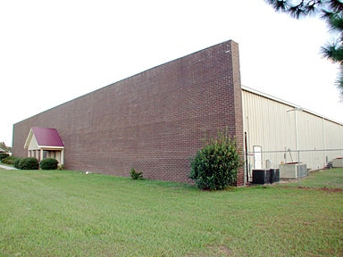


Property Detail
204 Hardman Rd
040D-085
4.97 AC S/S HARDMAN RD
Officebuilding
Liberty
I1
Georgia
A Areas with a 1% annual chance of flooding and a 26% chance of flooding over the life of a 30-year mortgage.
4.97 AC
2025
Liberty County
2025
Savannah
010208
Hinesville, GA
4,000 SF
NEARBY LISTINGS FOR SALE OR LEASE
-
-
View all Hinesville listings for lease on LoopNet.com
DEMOGRAPHICS near 204 Hardman Rd
1 mile
3 mile
5 mile
2025 Total Population
2,792
20,915
41,205
2030 Population
3,030
22,799
44,905
Pop Growth 2025-2030
+ 8.52%
+ 9.01%
+ 8.98%
Average Age
33
33
33
2025 Total Households
979
7,423
14,989
HH Growth 2025-2030
+ 8.68%
+ 9.05%
+ 8.87%
Median Household Inc
$65,148
$61,761
$61,077
Avg Household Size
2.80
2.70
2.70
2025 Avg HH Vehicles
2.00
2.00
2.00
Median Home Value
$161,589
$177,285
$191,586
Median Year Built
1996
1993
1993
Nearby Places
Map Layers
Map Styles
 Street
 Aerial
Layers
 Traffic
 Biking
Places
Listings with unknown addresses are not visible on the map
- Restaurants
- Banks
- Shops
- Fitness
- Groceries
SALE & LEASE HISTORY
LISTING DATE
SALE/LEASE

Jan 03, 2017
For Sale
Dec 18, 2017
For Lease
Nearby Properties
Address
Land Use
TOTAL SIZE
Lot Size
Zoning
Address
Land Use
TOTAL SIZE
Lot Size
Zoning
11,944 SF
39.41 AC
LI
Address
Land Use
TOTAL SIZE
Lot Size
Zoning
81,366 SF
35.17 AC
R8
Address
Land Use
TOTAL SIZE
Lot Size
Zoning
81,366 SF
16.50 AC
R20
Address
Land Use
TOTAL SIZE
Lot Size
Zoning
71,899 SF
50.12 AC
LI
Address
Land Use
TOTAL SIZE
Lot Size
Zoning
53,103 SF
34.03 AC
I1
Address
Land Use
TOTAL SIZE
Lot Size
Zoning
12,261 SF
10.99 AC
C2
Address
Land Use
TOTAL SIZE
Lot Size
Zoning
42,572 SF
5.27 AC
C2
Address
Land Use
TOTAL SIZE
Lot Size
Zoning
896 SF
1,579.79 AC
UNZONED RU
Address
Land Use
TOTAL SIZE
Lot Size
Zoning
46,592 SF
10.49 AC
MFR
Address
Land Use
TOTAL SIZE
Lot Size
Zoning
13,500 SF
4.90 AC
LI
Address
Land Use
TOTAL SIZE
Lot Size
Zoning
29,704 SF
3.09 AC
AR1
Address
Land Use
TOTAL SIZE
Lot Size
Zoning
23,314 SF
4.70 AC
C2/C3/R8
Address
Land Use
TOTAL SIZE
Lot Size
Zoning
12,000 SF
4.14 AC
AR1
Address
Land Use
TOTAL SIZE
Lot Size
Zoning
2,000 SF
69 AC
LI
Address
Land Use
TOTAL SIZE
Lot Size
Zoning
27,129 SF
7.29 AC
LI
Address
Land Use
TOTAL SIZE
Lot Size
Zoning
76.06 AC
LI
Address
Land Use
TOTAL SIZE
Lot Size
Zoning
17,218 SF
2.28 AC
MFR
Address
Land Use
TOTAL SIZE
Lot Size
Zoning
20,000 SF
37.93 AC
COMMERCIAL
Address
Land Use
TOTAL SIZE
Lot Size
Zoning
8,881 SF
11.57 AC
R20
Address
Land Use
TOTAL SIZE
Lot Size
Zoning
976 SF
24.23 AC
COMMERCIAL
Address
Land Use
TOTAL SIZE
Lot Size
Zoning
11,544 SF
2.47 AC
MFR
Address
Land Use
TOTAL SIZE
Lot Size
Zoning
4,560 SF
2.58 AC
C3
Address
Land Use
TOTAL SIZE
Lot Size
Zoning
115,570 SF
14.60 AC
I1
Address
Land Use
TOTAL SIZE
Lot Size
Zoning
27.38 AC
MHP/PUD
Address
Land Use
TOTAL SIZE
Lot Size
Zoning
1,075 SF
4 AC
RA1
Address
Land Use
TOTAL SIZE
Lot Size
Zoning
11,356 SF
11.79 AC
OI
Address
Land Use
TOTAL SIZE
Lot Size
Zoning
10,000 SF
25 AC
UNZONED RU
Address
Land Use
TOTAL SIZE
Lot Size
Zoning
12,000 SF
2.25 AC
UNZONED RU
Address
Land Use
TOTAL SIZE
Lot Size
Zoning
7,100 SF
3.73 AC
R8
Address
Land Use
TOTAL SIZE
Lot Size
Zoning
1,632 SF
2.97 AC
C3
The World's #1 Commercial Real Estate Marketplace
Connect with us
© 2026 CoStar Group
The information above has been obtained from sources believed reliable. While we do not doubt its accuracy we have not verified it and make no guarantee, warranty or representation about it. It is your responsibility to independently confirm its accuracy and completeness. Any projections, opinions, assumptions, or estimates used are for example only and do not represent the current or future performance of the property. The value of this transaction to you depends on tax and other factors which should be evaluated by your tax, financial, and legal advisors. You and your advisors should conduct a careful, independent investigation of the property to determine to your satisfaction the suitability of the property for your needs.