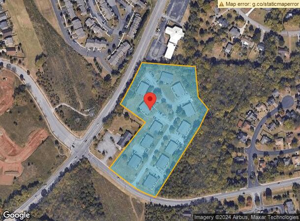
Property Record
204 Safe Harbor Dr, Goodlettsville, TN 37072

NEARBY LISTINGS FOR SALE OR LEASE
-
-
View all Goodlettsville listings for sale on LoopNet.com
Property Detail
204 Safe Harbor Dr
Nashville-Davidson--Murfreesboro--Franklin, TN
Rivergate Acres Limited
033-00-0-123
LOT 4 RIVERGATE ACRES SEC 1
Apartment
Davidson
X
Tennessee
47037C0136J
4
2025
7.06 AC
2025
Northeast Nashville
010302
Nashville
3,528 SF
DEMOGRAPHICS near 204 Safe Harbor Dr
1 Mile
3 Mile
5 Mile
2024 Total Population
6,278
36,017
87,840
2029 Population
6,213
35,822
88,900
Pop Growth 2024-2029
(1.04%)
(0.54%)
+ 1.21%
Average Age
40
40
40
2024 Total Households
2,619
15,045
36,181
HH Growth 2024-2029
(1.45%)
(1.06%)
+ 0.78%
Median Household Inc
$55,488
$57,201
$58,884
Avg Household Size
2.40
2.30
2.40
2024 Avg HH Vehicles
2.00
2.00
2.00
Median Home Value
$255,164
$265,340
$286,714
Median Year Built
1985
1983
1984
Nearby Places
Map Layers
Map Styles
 Street
 Aerial
- Restaurants
- Banks
- Shops
- Fitness
- Groceries
PUBLIC TRANSPORTATION
AIRPORT
Nashville International
DRIVE
WALK
Distance
Nashville International
27 min
19.4 mi
Freight Ports
Port of Mobile
DRIVE
WALK
Distance
Port of Mobile
500 min
456.9 mi
Nearby Properties
Address
Land Use
TOTAL SIZE
Lot Size
Zoning
Address
Land Use
TOTAL SIZE
Lot Size
Zoning
26,434 SF
12.86 AC
RM20
Address
Land Use
TOTAL SIZE
Lot Size
Zoning
30,534 SF
19.77 AC
SP
Address
Land Use
TOTAL SIZE
Lot Size
Zoning
102,431 SF
19.59 AC
6ZZ
Address
Land Use
TOTAL SIZE
Lot Size
Zoning
336,784 SF
41.54 AC
IR
Address
Land Use
TOTAL SIZE
Lot Size
Zoning
16,770 SF
76.79 AC
RM4
Address
Land Use
TOTAL SIZE
Lot Size
Zoning
17,214 SF
40.52 AC
RM9
Address
Land Use
TOTAL SIZE
Lot Size
Zoning
6,120 SF
17.46 AC
R10
Address
Land Use
TOTAL SIZE
Lot Size
Zoning
31,528 SF
17.61 AC
6ZZ
Address
Land Use
TOTAL SIZE
Lot Size
Zoning
26,872 SF
24.16 AC
6ZZ
Address
Land Use
TOTAL SIZE
Lot Size
Zoning
72,951 SF
5.31 AC
6ZZ
Address
Land Use
TOTAL SIZE
Lot Size
Zoning
3,993 SF
21.86 AC
6ZZ
Address
Land Use
TOTAL SIZE
Lot Size
Zoning
42,840 SF
21.43 AC
CS
Address
Land Use
TOTAL SIZE
Lot Size
Zoning
3,312 SF
33.03 AC
IR
Address
Land Use
TOTAL SIZE
Lot Size
Zoning
12,576 SF
16.09 AC
6ZZ
Address
Land Use
TOTAL SIZE
Lot Size
Zoning
34,752 SF
19.09 AC
CS
Address
Land Use
TOTAL SIZE
Lot Size
Zoning
93,000 SF
16.44 AC
IR
Address
Land Use
TOTAL SIZE
Lot Size
Zoning
112,056 SF
40.15 AC
MULTIZONE
Address
Land Use
TOTAL SIZE
Lot Size
Zoning
26,610 SF
6.66 AC
RS20
Address
Land Use
TOTAL SIZE
Lot Size
Zoning
21,356 SF
11.25 AC
6ZZ
Address
Land Use
TOTAL SIZE
Lot Size
Zoning
28,000 SF
38.86 AC
6ZZ
Address
Land Use
TOTAL SIZE
Lot Size
Zoning
10,312 SF
15.03 AC
6ZZ
Address
Land Use
TOTAL SIZE
Lot Size
Zoning
17,500 SF
17.56 AC
SCR
Address
Land Use
TOTAL SIZE
Lot Size
Zoning
49,752 SF
5.36 AC
RS20
Address
Land Use
TOTAL SIZE
Lot Size
Zoning
10,336 SF
17.70 AC
6ZZ
Address
Land Use
TOTAL SIZE
Lot Size
Zoning
15,600 SF
23.88 AC
RM9
Address
Land Use
TOTAL SIZE
Lot Size
Zoning
6,948 SF
12.62 AC
6ZZ
Address
Land Use
TOTAL SIZE
Lot Size
Zoning
44,394 SF
2.49 AC
Address
Land Use
TOTAL SIZE
Lot Size
Zoning
10,378 SF
15.33 AC
6ZZ
Address
Land Use
TOTAL SIZE
Lot Size
Zoning
93,232 SF
5.40 AC
RM20
Address
Land Use
TOTAL SIZE
Lot Size
Zoning
18,482 SF
27 AC
6ZZ
The World's #1 Commercial Real Estate Marketplace
Connect with us
© 2026 CoStar Group
The information above has been obtained from sources believed reliable. While we do not doubt its accuracy we have not verified it and make no guarantee, warranty or representation about it. It is your responsibility to independently confirm its accuracy and completeness. Any projections, opinions, assumptions, or estimates used are for example only and do not represent the current or future performance of the property. The value of this transaction to you depends on tax and other factors which should be evaluated by your tax, financial, and legal advisors. You and your advisors should conduct a careful, independent investigation of the property to determine to your satisfaction the suitability of the property for your needs.