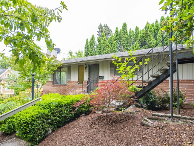
Property Record
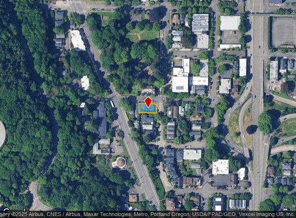
204 Sw Woods St, Portland, OR 97201

NEARBY LISTINGS FOR SALE OR LEASE
Property Detail
204 Sw Woods St
Portland-Vancouver-Hillsboro, OR-WA
Caruthers Add
R128985
Multnomah
Triplex
Oregon
ARE
0.12 AC
41067C0400E
South Portland
2,464 SF
Portland
DEMOGRAPHICS near 204 Sw Woods St
1 Mile
3 Mile
5 Mile
2024 Total Population
24,064
189,042
432,289
2029 Population
24,783
187,686
427,257
Pop Growth 2024-2029
+ 2.99%
(0.72%)
(1.16%)
Average Age
39
40
41
2024 Total Households
13,695
99,692
202,943
HH Growth 2024-2029
+ 3.06%
(0.72%)
(1.21%)
Median Household Inc
$83,086
$81,365
$90,622
Avg Household Size
1.60
1.80
2.00
2024 Avg HH Vehicles
1.00
1.00
1.00
Median Home Value
$700,314
$708,539
$670,454
Median Year Built
2002
1974
1964
Nearby Places
Map Layers
Map Styles
 Street
 Aerial
- Restaurants
- Banks
- Shops
- Fitness
- Groceries
PUBLIC TRANSPORTATION
TRANSIT/SUBWAY
Ohsu Commons (Portland Streetcar - Tri-County Metropolitan Transportation District of Oregon Rail (TriMet Rail))
DRIVE
WALK
Distance
Ohsu Commons (Portland Streetcar - Tri-County Metropolitan Transportation District of Oregon Rail (TriMet Rail))
5 min
11 min
0.6 mi
Lincoln St/Sw 3Rd Ave Max Station (MAX Orange Line - TriMet)
DRIVE
WALK
Distance
Lincoln St/Sw 3Rd Ave Max Station (MAX Orange Line - TriMet)
2 min
11 min
0.6 mi
Sw Moody & Gaines (Portland Streetcar - Tri-County Metropolitan Transportation District of Oregon Rail (TriMet Rail))
DRIVE
WALK
Distance
Sw Moody & Gaines (Portland Streetcar - Tri-County Metropolitan Transportation District of Oregon Rail (TriMet Rail))
4 min
13 min
0.7 mi
S Moody & Meade South (Portland Streetcar - A Loop - Portland Streetcar, Portland Streetcar - B Loop - Portland Streetcar, Portland Streetcar - NS Line - Portland Streetcar)
DRIVE
WALK
Distance
S Moody & Meade South (Portland Streetcar - A Loop - Portland Streetcar, Portland Streetcar - B Loop - Portland Streetcar, Portland Streetcar - NS Line - Portland Streetcar)
3 min
14 min
0.7 mi
South Waterfront/S Moody Max Station (MAX Orange Line - TriMet)
DRIVE
WALK
Distance
South Waterfront/S Moody Max Station (MAX Orange Line - TriMet)
3 min
15 min
0.8 mi
COMMUTER RAIL
Portland (Amtrak Cascades - Amtrak, Coast Starlight - Amtrak, Empire Builder - Amtrak)
DRIVE
WALK
Distance
Portland (Amtrak Cascades - Amtrak, Coast Starlight - Amtrak, Empire Builder - Amtrak)
7 min
2.6 mi
Beaverton Transit Center (West Side Express) (Westside Express Service - Tri-County Metropolitan Transportation District of Oregon Rail (TriMet Rail))
DRIVE
WALK
Distance
Beaverton Transit Center (West Side Express) (Westside Express Service - Tri-County Metropolitan Transportation District of Oregon Rail (TriMet Rail))
14 min
8.3 mi
AIRPORT
Portland International
DRIVE
WALK
Distance
Portland International
24 min
14.1 mi
Freight Ports
Port of Portland
DRIVE
WALK
Distance
Port of Portland
7 min
4.0 mi
SALE & LEASE HISTORY
LISTING DATE
SALE/LEASE

Jul 12, 2019
For Sale
Jul 07, 2019
For Sale
Nearby Properties
Address
Land Use
TOTAL SIZE
Lot Size
Zoning
Address
Land Use
TOTAL SIZE
Lot Size
Zoning
395,815 SF
2.66 AC
IRD
Address
Land Use
TOTAL SIZE
Lot Size
Zoning
27.58 AC
EX
Address
Land Use
TOTAL SIZE
Lot Size
Zoning
627,500 SF
16.60 AC
CX
Address
Land Use
TOTAL SIZE
Lot Size
Zoning
822,867 SF
103.39 AC
CI1
Address
Land Use
TOTAL SIZE
Lot Size
Zoning
57,314 SF
60.69 AC
OS
Address
Land Use
TOTAL SIZE
Lot Size
Zoning
560,000 SF
0.15 AC
CX
Address
Land Use
TOTAL SIZE
Lot Size
Zoning
20.71 AC
OS
Address
Land Use
TOTAL SIZE
Lot Size
Zoning
409,260 SF
7.41 AC
EX
Address
Land Use
TOTAL SIZE
Lot Size
Zoning
1.09 AC
EX
Address
Land Use
TOTAL SIZE
Lot Size
Zoning
2.24 AC
CX
Address
Land Use
TOTAL SIZE
Lot Size
Zoning
326,547 SF
2.42 AC
RH
Address
Land Use
TOTAL SIZE
Lot Size
Zoning
304,836 SF
10.85 AC
CX
Address
Land Use
TOTAL SIZE
Lot Size
Zoning
417,324 SF
0.68 AC
CX
Address
Land Use
TOTAL SIZE
Lot Size
Zoning
598,328 SF
12.32 AC
CX
Address
Land Use
TOTAL SIZE
Lot Size
Zoning
257,700 SF
2.89 AC
EX
Address
Land Use
TOTAL SIZE
Lot Size
Zoning
128,500 SF
6.95 AC
OS
Address
Land Use
TOTAL SIZE
Lot Size
Zoning
460,000 SF
0.92 AC
CX
Address
Land Use
TOTAL SIZE
Lot Size
Zoning
689,840 SF
0.92 AC
CX
Address
Land Use
TOTAL SIZE
Lot Size
Zoning
125,217 SF
0.23 AC
CX
Address
Land Use
TOTAL SIZE
Lot Size
Zoning
97,465 SF
107.18 AC
OS
Address
Land Use
TOTAL SIZE
Lot Size
Zoning
7.78 AC
EX
Address
Land Use
TOTAL SIZE
Lot Size
Zoning
426,742 SF
0.53 AC
RXD
Address
Land Use
TOTAL SIZE
Lot Size
Zoning
584,483 SF
0.90 AC
CX
Address
Land Use
TOTAL SIZE
Lot Size
Zoning
247,520 SF
7.74 AC
CX
Address
Land Use
TOTAL SIZE
Lot Size
Zoning
306,000 SF
1.21 AC
NULL
Address
Land Use
TOTAL SIZE
Lot Size
Zoning
251,293 SF
14.15 AC
IR
Address
Land Use
TOTAL SIZE
Lot Size
Zoning
596,161 SF
0.92 AC
CX
Address
Land Use
TOTAL SIZE
Lot Size
Zoning
456,760 SF
0.53 AC
EX
Address
Land Use
TOTAL SIZE
Lot Size
Zoning
193,898 SF
2.50 AC
IRD
Address
Land Use
TOTAL SIZE
Lot Size
Zoning
387,000 SF
0.88 AC
CXD
The World's #1 Commercial Real Estate Marketplace
Connect with us
© 2025 CoStar Group
The information above has been obtained from sources believed reliable. While we do not doubt its accuracy we have not verified it and make no guarantee, warranty or representation about it. It is your responsibility to independently confirm its accuracy and completeness. Any projections, opinions, assumptions, or estimates used are for example only and do not represent the current or future performance of the property. The value of this transaction to you depends on tax and other factors which should be evaluated by your tax, financial, and legal advisors. You and your advisors should conduct a careful, independent investigation of the property to determine to your satisfaction the suitability of the property for your needs.