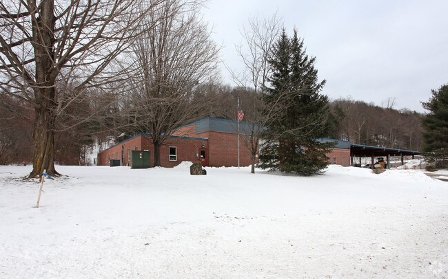
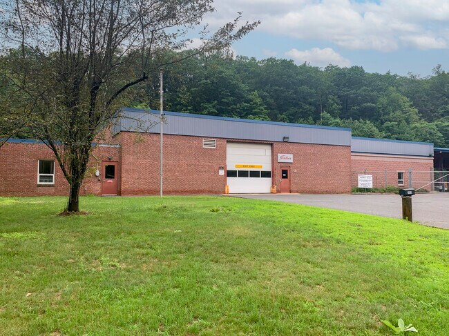
Property Record
204 Torrington Rd, Winsted, CT 06098
NEARBY LISTINGS FOR SALE OR LEASE
Property Detail
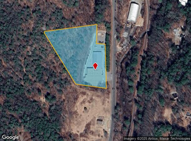
204 Torrington Rd
Torrington, CT
Litchfield
WINC-000045-000158-000049A-005586
Connecticut
Commercialbuilding
49a
2025
5.57 AC
2025
Rt 8/Winsted
320102
Hartford
22,813 SF
DEMOGRAPHICS near 204 Torrington Rd
1 Mile
3 Mile
5 Mile
2024 Total Population
544
12,975
24,696
2029 Population
560
13,176
24,853
Pop Growth 2024-2029
+ 2.94%
+ 1.55%
+ 0.64%
Average Age
45
45
45
2024 Total Households
230
5,530
10,622
HH Growth 2024-2029
+ 3.04%
+ 1.52%
+ 0.58%
Median Household Inc
$82,102
$75,806
$79,276
Avg Household Size
2.30
2.30
2.30
2024 Avg HH Vehicles
2.00
2.00
2.00
Median Home Value
$221,774
$232,578
$234,847
Median Year Built
1971
1967
1971
Nearby Places
Map Layers
Map Styles
 Street
 Aerial
- Restaurants
- Banks
- Shops
- Fitness
- Groceries
PUBLIC TRANSPORTATION
AIRPORT
Bradley International
DRIVE
WALK
Distance
Bradley International
55 min
26.0 mi
SALE & LEASE HISTORY
LISTING DATE
SALE/LEASE

Aug 19, 2021
For Sale
Nearby Properties
Address
Land Use
TOTAL SIZE
Lot Size
Zoning
Address
Land Use
TOTAL SIZE
Lot Size
Zoning
224,385 SF
26.20 AC
RU-2
Address
Land Use
TOTAL SIZE
Lot Size
Zoning
13.79 AC
CX
Address
Land Use
TOTAL SIZE
Lot Size
Zoning
95,810 SF
5.60 AC
R-3
Address
Land Use
TOTAL SIZE
Lot Size
Zoning
76,339 SF
124.53 AC
R-1
Address
Land Use
TOTAL SIZE
Lot Size
Zoning
200,000 SF
32.82 AC
IP
Address
Land Use
TOTAL SIZE
Lot Size
Zoning
20,544 SF
2.42 AC
CB-2
Address
Land Use
TOTAL SIZE
Lot Size
Zoning
56,852 SF
3 AC
R-3
Address
Land Use
TOTAL SIZE
Lot Size
Zoning
54,920 SF
11.87 AC
R-3
Address
Land Use
TOTAL SIZE
Lot Size
Zoning
24,618 SF
3.63 AC
CB-2
Address
Land Use
TOTAL SIZE
Lot Size
Zoning
5.11 AC
R-3
Address
Land Use
TOTAL SIZE
Lot Size
Zoning
2.32 AC
CB-2
Address
Land Use
TOTAL SIZE
Lot Size
Zoning
132,962 SF
7.30 AC
IP
Address
Land Use
TOTAL SIZE
Lot Size
Zoning
53,252 SF
32.19 AC
RU-1
Address
Land Use
TOTAL SIZE
Lot Size
Zoning
93,750 SF
9.19 AC
IP
Address
Land Use
TOTAL SIZE
Lot Size
Zoning
129,282 SF
27.60 AC
I
Address
Land Use
TOTAL SIZE
Lot Size
Zoning
90,039 SF
6.98 AC
IP
Address
Land Use
TOTAL SIZE
Lot Size
Zoning
33,268 SF
5.27 AC
RA-2
Address
Land Use
TOTAL SIZE
Lot Size
Zoning
193.61 AC
I
Address
Land Use
TOTAL SIZE
Lot Size
Zoning
10.69 AC
IP
Address
Land Use
TOTAL SIZE
Lot Size
Zoning
338.20 AC
R2
Address
Land Use
TOTAL SIZE
Lot Size
Zoning
50,068 SF
1.97 AC
R-3
Address
Land Use
TOTAL SIZE
Lot Size
Zoning
24,000 SF
0.44 AC
CB-2
Address
Land Use
TOTAL SIZE
Lot Size
Zoning
77,420 SF
8.70 AC
IP
Address
Land Use
TOTAL SIZE
Lot Size
Zoning
14.46 AC
R-1
Address
Land Use
TOTAL SIZE
Lot Size
Zoning
42,850 SF
0.36 AC
CB-3
Address
Land Use
TOTAL SIZE
Lot Size
Zoning
10.25 AC
IP
Address
Land Use
TOTAL SIZE
Lot Size
Zoning
50,096 SF
9.66 AC
IP
Address
Land Use
TOTAL SIZE
Lot Size
Zoning
161.20 AC
R60
Address
Land Use
TOTAL SIZE
Lot Size
Zoning
3.17 AC
IB-3
Address
Land Use
TOTAL SIZE
Lot Size
Zoning
14,496 SF
4.50 AC
LB
The World's #1 Commercial Real Estate Marketplace
Connect with us
© 2026 CoStar Group
The information above has been obtained from sources believed reliable. While we do not doubt its accuracy we have not verified it and make no guarantee, warranty or representation about it. It is your responsibility to independently confirm its accuracy and completeness. Any projections, opinions, assumptions, or estimates used are for example only and do not represent the current or future performance of the property. The value of this transaction to you depends on tax and other factors which should be evaluated by your tax, financial, and legal advisors. You and your advisors should conduct a careful, independent investigation of the property to determine to your satisfaction the suitability of the property for your needs.