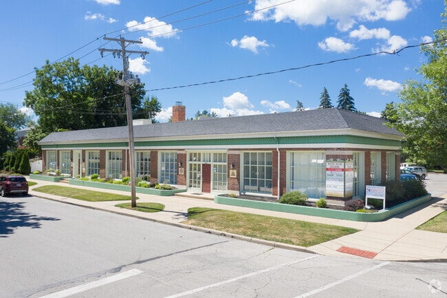
Property Record
204 W Wayne St, Maumee, OH 43537
NEARBY LISTINGS FOR SALE OR LEASE
Property Detail
204 W Wayne St
Toledo, OH
First Plat
36-07974
FIRST PLAT LOT 74 E 55 FT W 60 FT
Warehouse
Lucas
X
Ohio
39173C0020D
74
0
0.17 AC
2025
South/Southwest
007102
Toledo
5,432 SF
DEMOGRAPHICS near 204 W Wayne St
1 mile
3 mile
5 mile
2024 Total Population
3,877
50,944
111,975
2029 Population
3,788
50,581
111,166
Pop Growth 2024-2029
(2.30%)
(0.71%)
(0.72%)
Average Age
42
41
41
2024 Total Households
1,685
22,184
48,584
HH Growth 2024-2029
(2.49%)
(0.90%)
(0.83%)
Median Household Inc
$86,064
$74,032
$69,161
Avg Household Size
2.30
2.30
2.20
2024 Avg HH Vehicles
2.00
2.00
2.00
Median Home Value
$180,955
$210,320
$207,322
Median Year Built
1956
1976
1978
Nearby Places
Map Layers
Map Styles
 Street
 Aerial
Transit
 Traffic
 Biking
Places
Listings with unknown addresses are not visible on the map
- Restaurants
- Banks
- Shops
- Fitness
- Groceries
PUBLIC TRANSPORTATION
COMMUTER RAIL
Drive
Walk
Distance
13 min
8.5 mi
AIRPORT
Eugene F Kranz Toledo Express
Drive
Walk
Distance
Eugene F Kranz Toledo Express
23 min
10.7 mi
SALE & LEASE HISTORY
LISTING DATE
SALE/LEASE

Sep 24, 2016
For Lease
Feb 24, 2020
For Lease
Nearby Properties
Address
Land Use
TOTAL SIZE
Lot Size
Zoning
Address
Land Use
TOTAL SIZE
Lot Size
Zoning
541,518 SF
21.30 AC
16-R1
Address
Land Use
TOTAL SIZE
Lot Size
Zoning
275,990 SF
49.65 AC
16-CM
Address
Land Use
TOTAL SIZE
Lot Size
Zoning
239,332 SF
31.53 AC
Address
Land Use
TOTAL SIZE
Lot Size
Zoning
168,191 SF
12.36 AC
Address
Land Use
TOTAL SIZE
Lot Size
Zoning
183,376 SF
16.04 AC
Address
Land Use
TOTAL SIZE
Lot Size
Zoning
67,264 SF
6.95 AC
16-CM
Address
Land Use
TOTAL SIZE
Lot Size
Zoning
162,934 SF
21.60 AC
Address
Land Use
TOTAL SIZE
Lot Size
Zoning
73,511 SF
5.94 AC
Address
Land Use
TOTAL SIZE
Lot Size
Zoning
165,573 SF
15.67 AC
Address
Land Use
TOTAL SIZE
Lot Size
Zoning
35.94 AC
17-C3
Address
Land Use
TOTAL SIZE
Lot Size
Zoning
3.56 AC
Address
Land Use
TOTAL SIZE
Lot Size
Zoning
78,923 SF
10.12 AC
Address
Land Use
TOTAL SIZE
Lot Size
Zoning
231,756 SF
31.37 AC
16-M1
Address
Land Use
TOTAL SIZE
Lot Size
Zoning
191,196 SF
25.90 AC
Address
Land Use
TOTAL SIZE
Lot Size
Zoning
269,263 SF
55.93 AC
16-R2
Address
Land Use
TOTAL SIZE
Lot Size
Zoning
125,697 SF
33.10 AC
Address
Land Use
TOTAL SIZE
Lot Size
Zoning
231,670 SF
18.04 AC
Address
Land Use
TOTAL SIZE
Lot Size
Zoning
606,883 SF
119.87 AC
16-M2
Address
Land Use
TOTAL SIZE
Lot Size
Zoning
352,382 SF
62.93 AC
16-M1
Address
Land Use
TOTAL SIZE
Lot Size
Zoning
337,990 SF
17.75 AC
16-M1
Address
Land Use
TOTAL SIZE
Lot Size
Zoning
43,956 SF
11.68 AC
Address
Land Use
TOTAL SIZE
Lot Size
Zoning
8.57 AC
16-M1
Address
Land Use
TOTAL SIZE
Lot Size
Zoning
608,280 SF
48.86 AC
16-M2
Address
Land Use
TOTAL SIZE
Lot Size
Zoning
80,668 SF
9.67 AC
Address
Land Use
TOTAL SIZE
Lot Size
Zoning
212,672 SF
15.98 AC
17-R1
Address
Land Use
TOTAL SIZE
Lot Size
Zoning
350,408 SF
20.83 AC
17-M2
Address
Land Use
TOTAL SIZE
Lot Size
Zoning
148,107 SF
26.16 AC
Address
Land Use
TOTAL SIZE
Lot Size
Zoning
340,924 SF
10.99 AC
Address
Land Use
TOTAL SIZE
Lot Size
Zoning
119.87 AC
16-M2
Address
Land Use
TOTAL SIZE
Lot Size
Zoning
73,389 SF
1.78 AC
The World's #1 Commercial Real Estate Marketplace
Connect with us
© 2026 CoStar Group
The information above has been obtained from sources believed reliable. While we do not doubt its accuracy we have not verified it and make no guarantee, warranty or representation about it. It is your responsibility to independently confirm its accuracy and completeness. Any projections, opinions, assumptions, or estimates used are for example only and do not represent the current or future performance of the property. The value of this transaction to you depends on tax and other factors which should be evaluated by your tax, financial, and legal advisors. You and your advisors should conduct a careful, independent investigation of the property to determine to your satisfaction the suitability of the property for your needs.