Property Record
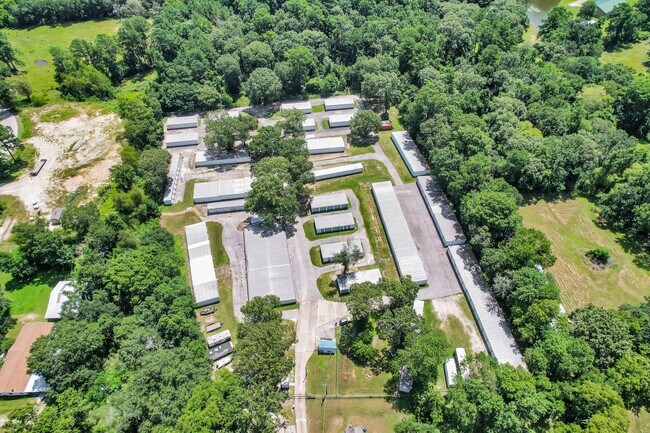
2040 Highway 30 E, Huntsville, TX 77320
Property Detail
2040 Highway 30 E
15555
BOBO F (A-74), TRACT 13.3, ACRES 3.0, LABEL# NTA1663642, SN1 CLW038661TX; TITLE # MH00593703
Commercialnec
WALKER
B and X Area of moderate flood hazard, usually the area between the limits of the 100-year and 500-year floods.
Texas
2025
3 AC
2025
Texas East Area
790103
Other Market Areas
768 SF
Huntsville, TX
NEARBY LISTINGS FOR SALE OR LEASE
-
-
View all Huntsville listings for sale on LoopNet.com
DEMOGRAPHICS near 2040 Highway 30 E
1 mile
3 mile
5 mile
2025 Total Population
1,205
19,303
41,395
2030 Population
1,279
20,552
43,649
Pop Growth 2025-2030
+ 6.14%
+ 6.47%
+ 5.45%
Average Age
38
34
34
2025 Total Households
453
6,156
14,892
HH Growth 2025-2030
+ 7.06%
+ 8.40%
+ 6.50%
Median Household Inc
$65,342
$40,742
$45,138
Avg Household Size
2.70
2.30
2.20
2025 Avg HH Vehicles
2.00
2.00
2.00
Median Home Value
$227,830
$205,155
$214,918
Median Year Built
1988
1992
1989
Nearby Places
Map Layers
Map Styles
 Street
 Aerial
Layers
 Traffic
 Biking
Places
Listings with unknown addresses are not visible on the map
- Restaurants
- Banks
- Shops
- Fitness
- Groceries
SALE & LEASE HISTORY
LISTING DATE
SALE/LEASE

Jul 31, 2025
For Sale
Nearby Properties
Address
Land Use
TOTAL SIZE
Lot Size
Zoning
Address
Land Use
TOTAL SIZE
Lot Size
Zoning
48,924 SF
125.60 AC
Address
Land Use
TOTAL SIZE
Lot Size
Zoning
266,498 SF
279.39 AC
Address
Land Use
TOTAL SIZE
Lot Size
Zoning
220,991 SF
7.11 AC
Address
Land Use
TOTAL SIZE
Lot Size
Zoning
130,891 SF
23.14 AC
Address
Land Use
TOTAL SIZE
Lot Size
Zoning
416,433 SF
12.19 AC
Address
Land Use
TOTAL SIZE
Lot Size
Zoning
178,134 SF
12.60 AC
Address
Land Use
TOTAL SIZE
Lot Size
Zoning
40,142 SF
7.05 AC
Address
Land Use
TOTAL SIZE
Lot Size
Zoning
Address
Land Use
TOTAL SIZE
Lot Size
Zoning
74,188 SF
20.71 AC
Address
Land Use
TOTAL SIZE
Lot Size
Zoning
141,611 SF
1.94 AC
Address
Land Use
TOTAL SIZE
Lot Size
Zoning
72,275 SF
13.10 AC
Address
Land Use
TOTAL SIZE
Lot Size
Zoning
68,574 SF
18.99 AC
Address
Land Use
TOTAL SIZE
Lot Size
Zoning
32,446 SF
1.14 AC
Address
Land Use
TOTAL SIZE
Lot Size
Zoning
10,178 SF
8.51 AC
Address
Land Use
TOTAL SIZE
Lot Size
Zoning
88,632 SF
8.75 AC
Address
Land Use
TOTAL SIZE
Lot Size
Zoning
Address
Land Use
TOTAL SIZE
Lot Size
Zoning
1,092 SF
3.63 AC
Address
Land Use
TOTAL SIZE
Lot Size
Zoning
30,252 SF
0.69 AC
Address
Land Use
TOTAL SIZE
Lot Size
Zoning
95,634 SF
5.49 AC
Address
Land Use
TOTAL SIZE
Lot Size
Zoning
117,321 SF
8.64 AC
Address
Land Use
TOTAL SIZE
Lot Size
Zoning
22,000 SF
1.74 AC
Address
Land Use
TOTAL SIZE
Lot Size
Zoning
8,794 SF
2.45 AC
Address
Land Use
TOTAL SIZE
Lot Size
Zoning
80,006 SF
3.46 AC
Address
Land Use
TOTAL SIZE
Lot Size
Zoning
Address
Land Use
TOTAL SIZE
Lot Size
Zoning
2.89 AC
Address
Land Use
TOTAL SIZE
Lot Size
Zoning
4,955 SF
1.50 AC
Address
Land Use
TOTAL SIZE
Lot Size
Zoning
27.68 AC
Address
Land Use
TOTAL SIZE
Lot Size
Zoning
22,428 SF
0.70 AC
Address
Land Use
TOTAL SIZE
Lot Size
Zoning
8,493 SF
247.10 AC
Address
Land Use
TOTAL SIZE
Lot Size
Zoning
27,483 SF
1.07 AC
The World's #1 Commercial Real Estate Marketplace
Connect with us
© 2026 CoStar Group
The information above has been obtained from sources believed reliable. While we do not doubt its accuracy we have not verified it and make no guarantee, warranty or representation about it. It is your responsibility to independently confirm its accuracy and completeness. Any projections, opinions, assumptions, or estimates used are for example only and do not represent the current or future performance of the property. The value of this transaction to you depends on tax and other factors which should be evaluated by your tax, financial, and legal advisors. You and your advisors should conduct a careful, independent investigation of the property to determine to your satisfaction the suitability of the property for your needs.