Property Record
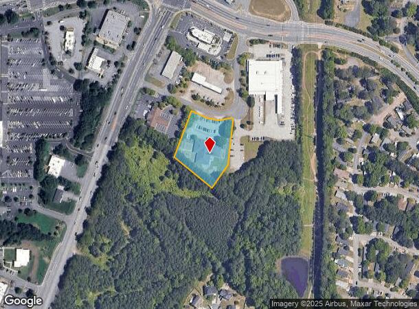
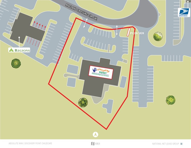
2040 Macland Crossing Cir Sw, Marietta, GA 30008

NEARBY LISTINGS FOR SALE OR LEASE
Property Detail
2040 Macland Crossing Cir Sw
19-0413-0-019-0
19Th District 2Nd Section
Daycare
Cobb
X
Georgia
13067C0113G
413
2025
1.39 AC
2025
Powder Spring/Austell
030908
Atlanta
9,864 SF
Atlanta-Sandy Springs-Roswell, GA
DEMOGRAPHICS near 2040 Macland Crossing Cir Sw
1 Mile
3 Mile
5 Mile
2024 Total Population
7,334
75,297
180,612
2029 Population
7,391
76,461
183,774
Pop Growth 2024-2029
+ 0.78%
+ 1.55%
+ 1.75%
Average Age
38
38
39
2024 Total Households
2,443
26,573
66,050
HH Growth 2024-2029
+ 0.65%
+ 1.52%
+ 1.73%
Median Household Inc
$85,723
$73,037
$78,021
Avg Household Size
2.90
2.70
2.60
2024 Avg HH Vehicles
2.00
2.00
2.00
Median Home Value
$265,284
$286,439
$309,092
Median Year Built
1988
1986
1986
Nearby Places
Map Layers
Map Styles
 Street
 Aerial
- Restaurants
- Banks
- Shops
- Fitness
- Groceries
PUBLIC TRANSPORTATION
AIRPORT
Hartsfield - Jackson Atlanta International
DRIVE
WALK
Distance
Hartsfield - Jackson Atlanta International
47 min
29.3 mi
SALE & LEASE HISTORY
LISTING DATE
SALE/LEASE

Sep 10, 2019
For Sale
Jul 08, 2019
For Sale
Nearby Properties
Address
Land Use
TOTAL SIZE
Lot Size
Zoning
Address
Land Use
TOTAL SIZE
Lot Size
Zoning
370,201 SF
28.35 AC
RM-12
Address
Land Use
TOTAL SIZE
Lot Size
Zoning
25,956 SF
12.78 AC
PVC
Address
Land Use
TOTAL SIZE
Lot Size
Zoning
488,748 SF
32.28 AC
RM-12
Address
Land Use
TOTAL SIZE
Lot Size
Zoning
285,190 SF
25.16 AC
RM-12
Address
Land Use
TOTAL SIZE
Lot Size
Zoning
225,315 SF
17.10 AC
RM-12
Address
Land Use
TOTAL SIZE
Lot Size
Zoning
236,808 SF
29.38 AC
PRD MF
Address
Land Use
TOTAL SIZE
Lot Size
Zoning
345,192 SF
22.67 AC
RM-12
Address
Land Use
TOTAL SIZE
Lot Size
Zoning
219,402 SF
10.33 AC
RM-12
Address
Land Use
TOTAL SIZE
Lot Size
Zoning
213,318 SF
19.28 AC
PRD MF
Address
Land Use
TOTAL SIZE
Lot Size
Zoning
217,980 SF
12.61 AC
PRD MF
Address
Land Use
TOTAL SIZE
Lot Size
Zoning
289,582 SF
21.01 AC
RM-12
Address
Land Use
TOTAL SIZE
Lot Size
Zoning
133,813 SF
10 AC
RM-12
Address
Land Use
TOTAL SIZE
Lot Size
Zoning
188,988 SF
15.30 AC
OI
Address
Land Use
TOTAL SIZE
Lot Size
Zoning
161,927 SF
7.95 AC
OI
Address
Land Use
TOTAL SIZE
Lot Size
Zoning
113,652 SF
9.40 AC
RM-12
Address
Land Use
TOTAL SIZE
Lot Size
Zoning
131,802 SF
4.76 AC
RM-12
Address
Land Use
TOTAL SIZE
Lot Size
Zoning
105,892 SF
14.07 AC
NRC/WS
Address
Land Use
TOTAL SIZE
Lot Size
Zoning
80,552 SF
10.94 AC
GC/WS
Address
Land Use
TOTAL SIZE
Lot Size
Zoning
44,097 SF
3.45 AC
OI
Address
Land Use
TOTAL SIZE
Lot Size
Zoning
38,418 SF
2.27 AC
GC
Address
Land Use
TOTAL SIZE
Lot Size
Zoning
94,074 SF
5 AC
PSC
Address
Land Use
TOTAL SIZE
Lot Size
Zoning
52,138 SF
10.10 AC
O&I/WS
Address
Land Use
TOTAL SIZE
Lot Size
Zoning
87,196 SF
4 AC
CRC
Address
Land Use
TOTAL SIZE
Lot Size
Zoning
133,030 SF
7.80 AC
PRD MF
Address
Land Use
TOTAL SIZE
Lot Size
Zoning
81,804 SF
3.53 AC
Address
Land Use
TOTAL SIZE
Lot Size
Zoning
80,572 SF
8.39 AC
GC
Address
Land Use
TOTAL SIZE
Lot Size
Zoning
98,851 SF
5.49 AC
LI
Address
Land Use
TOTAL SIZE
Lot Size
Zoning
67,280 SF
3.57 AC
RM-12
Address
Land Use
TOTAL SIZE
Lot Size
Zoning
120,298 SF
13.95 AC
GC
Address
Land Use
TOTAL SIZE
Lot Size
Zoning
78,173 SF
4.77 AC
PRD MF
The World's #1 Commercial Real Estate Marketplace
Connect with us
© 2025 CoStar Group
The information above has been obtained from sources believed reliable. While we do not doubt its accuracy we have not verified it and make no guarantee, warranty or representation about it. It is your responsibility to independently confirm its accuracy and completeness. Any projections, opinions, assumptions, or estimates used are for example only and do not represent the current or future performance of the property. The value of this transaction to you depends on tax and other factors which should be evaluated by your tax, financial, and legal advisors. You and your advisors should conduct a careful, independent investigation of the property to determine to your satisfaction the suitability of the property for your needs.