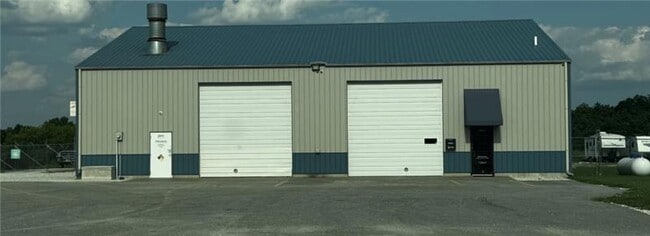
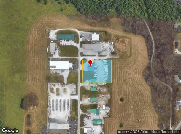
Property Record
2040 N James River Ct, Nixa, MO 65714

NEARBY LISTINGS FOR SALE OR LEASE
Property Detail
2040 N James River Ct
Springfield, MO
James River Industrial
05-0.8-34-001-002-027.003
LOT 1 JAMES RIVER INDUSTRIAL REPLAT LOT 3A OF REPLAT OF LOTS 3, 4, 5
Agriculturalland
Christian
X
Missouri
29043C0054D
1-3a
2024
1.82 AC
2024
West Christian County
020202
Springfield
5,880 SF
DEMOGRAPHICS near 2040 N James River Ct
1 Mile
3 Mile
5 Mile
2024 Total Population
1,253
32,286
101,717
2029 Population
1,473
35,850
112,355
Pop Growth 2024-2029
+ 17.56%
+ 11.04%
+ 10.46%
Average Age
41
41
41
2024 Total Households
458
12,460
41,955
HH Growth 2024-2029
+ 17.69%
+ 11.24%
+ 10.24%
Median Household Inc
$69,603
$91,107
$74,506
Avg Household Size
2.70
2.60
2.40
2024 Avg HH Vehicles
2.00
2.00
2.00
Median Home Value
$352,343
$323,155
$289,445
Median Year Built
1993
1997
1994
Nearby Places
Map Layers
Map Styles
 Street
 Aerial
- Restaurants
- Banks
- Shops
- Fitness
- Groceries
PUBLIC TRANSPORTATION
AIRPORT
Springfield-Branson Ntl
DRIVE
WALK
Distance
Springfield-Branson Ntl
37 min
17.8 mi
SALE & LEASE HISTORY
LISTING DATE
SALE/LEASE

Jun 27, 2025
For Lease
Nearby Properties
Address
Land Use
TOTAL SIZE
Lot Size
Zoning
Address
Land Use
TOTAL SIZE
Lot Size
Zoning
26.20 AC
Address
Land Use
TOTAL SIZE
Lot Size
Zoning
310,792 SF
12.27 AC
Address
Land Use
TOTAL SIZE
Lot Size
Zoning
18.16 AC
Address
Land Use
TOTAL SIZE
Lot Size
Zoning
4.12 AC
INC
Address
Land Use
TOTAL SIZE
Lot Size
Zoning
5.59 AC
INC
Address
Land Use
TOTAL SIZE
Lot Size
Zoning
10,720 SF
9.71 AC
Address
Land Use
TOTAL SIZE
Lot Size
Zoning
21.59 AC
INC
Address
Land Use
TOTAL SIZE
Lot Size
Zoning
126,557 SF
4.62 AC
INC
Address
Land Use
TOTAL SIZE
Lot Size
Zoning
125,218 SF
4.68 AC
INC
Address
Land Use
TOTAL SIZE
Lot Size
Zoning
30,049 SF
5.01 AC
Address
Land Use
TOTAL SIZE
Lot Size
Zoning
3,080 SF
24.20 AC
Address
Land Use
TOTAL SIZE
Lot Size
Zoning
19,682 SF
7.17 AC
Address
Land Use
TOTAL SIZE
Lot Size
Zoning
Address
Land Use
TOTAL SIZE
Lot Size
Zoning
107,194 SF
39.40 AC
Address
Land Use
TOTAL SIZE
Lot Size
Zoning
23,660 SF
10 AC
Address
Land Use
TOTAL SIZE
Lot Size
Zoning
71,436 SF
2.86 AC
INC
Address
Land Use
TOTAL SIZE
Lot Size
Zoning
13,836 SF
5.81 AC
Address
Land Use
TOTAL SIZE
Lot Size
Zoning
36,110 SF
7 AC
Address
Land Use
TOTAL SIZE
Lot Size
Zoning
1.44 AC
INC
Address
Land Use
TOTAL SIZE
Lot Size
Zoning
13,940 SF
3.43 AC
Address
Land Use
TOTAL SIZE
Lot Size
Zoning
6.11 AC
Address
Land Use
TOTAL SIZE
Lot Size
Zoning
58,989 SF
3.25 AC
INC
Address
Land Use
TOTAL SIZE
Lot Size
Zoning
18,966 SF
4.71 AC
Address
Land Use
TOTAL SIZE
Lot Size
Zoning
200,000 SF
10 AC
Address
Land Use
TOTAL SIZE
Lot Size
Zoning
8,100 SF
6.95 AC
Address
Land Use
TOTAL SIZE
Lot Size
Zoning
15,774 SF
10 AC
Address
Land Use
TOTAL SIZE
Lot Size
Zoning
22,150 SF
7.41 AC
Address
Land Use
TOTAL SIZE
Lot Size
Zoning
39,380 SF
2.50 AC
Address
Land Use
TOTAL SIZE
Lot Size
Zoning
1.95 AC
INC
Address
Land Use
TOTAL SIZE
Lot Size
Zoning
29,710 SF
2.03 AC
INC
The World's #1 Commercial Real Estate Marketplace
Connect with us
© 2025 CoStar Group
The information above has been obtained from sources believed reliable. While we do not doubt its accuracy we have not verified it and make no guarantee, warranty or representation about it. It is your responsibility to independently confirm its accuracy and completeness. Any projections, opinions, assumptions, or estimates used are for example only and do not represent the current or future performance of the property. The value of this transaction to you depends on tax and other factors which should be evaluated by your tax, financial, and legal advisors. You and your advisors should conduct a careful, independent investigation of the property to determine to your satisfaction the suitability of the property for your needs.