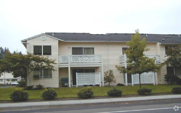
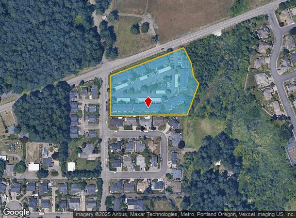
Property Record
2040 N Redwood St, Canby, OR 97013

NEARBY LISTINGS FOR SALE OR LEASE
-
-
View all Canby listings for sale on LoopNet.com
Property Detail
2040 N Redwood St
Portland-Vancouver-Hillsboro, OR-WA
Partition Plat
01870201
1993-15 PARTITION PLAT PT PARCEL 1
Multifamilydwelling
Clackamas
X
Oregon
41067C0650E
1
2025
3.35 AC
2025
Canby
022901
Portland
DEMOGRAPHICS near 2040 N Redwood St
1 mile
3 mile
5 mile
2024 Total Population
6,115
22,215
53,504
2029 Population
6,334
22,750
54,647
Pop Growth 2024-2029
+ 3.58%
+ 2.41%
+ 2.14%
Average Age
41
42
42
2024 Total Households
2,248
8,063
20,315
HH Growth 2024-2029
+ 3.56%
+ 2.41%
+ 2.14%
Median Household Inc
$90,057
$86,283
$93,639
Avg Household Size
2.70
2.70
2.60
2024 Avg HH Vehicles
2.00
2.00
2.00
Median Home Value
$467,999
$454,279
$551,236
Median Year Built
1992
1990
1991
Nearby Places
Map Layers
Map Styles
 Street
 Aerial
Transit
 Traffic
 Biking
Places
Listings with unknown addresses are not visible on the map
- Restaurants
- Banks
- Shops
- Fitness
- Groceries
PUBLIC TRANSPORTATION
COMMUTER RAIL
Drive
Walk
Distance
16 min
8.6 mi
Wilsonville (Westside Express Service - Tri-County Metropolitan Transportation District of Oregon Rail (TriMet Rail))
Drive
Walk
Distance
Wilsonville (Westside Express Service - Tri-County Metropolitan Transportation District of Oregon Rail (TriMet Rail))
19 min
9.9 mi
AIRPORT
Portland International
Drive
Walk
Distance
Portland International
41 min
26.4 mi
Freight Ports
Port of Portland
Drive
Walk
Distance
Port of Portland
43 min
23.7 mi
Nearby Properties
Address
Land Use
TOTAL SIZE
Lot Size
Zoning
Address
Land Use
TOTAL SIZE
Lot Size
Zoning
40.74 AC
R1
Address
Land Use
TOTAL SIZE
Lot Size
Zoning
Address
Land Use
TOTAL SIZE
Lot Size
Zoning
37.48 AC
R1
Address
Land Use
TOTAL SIZE
Lot Size
Zoning
35.33 AC
M1
Address
Land Use
TOTAL SIZE
Lot Size
Zoning
1,432 SF
12.96 AC
CM
Address
Land Use
TOTAL SIZE
Lot Size
Zoning
10 AC
M2
Address
Land Use
TOTAL SIZE
Lot Size
Zoning
4.88 AC
R1.5
Address
Land Use
TOTAL SIZE
Lot Size
Zoning
15 AC
R1
Address
Land Use
TOTAL SIZE
Lot Size
Zoning
9.67 AC
R2
Address
Land Use
TOTAL SIZE
Lot Size
Zoning
9.26 AC
M1
Address
Land Use
TOTAL SIZE
Lot Size
Zoning
15.85 AC
R1
Address
Land Use
TOTAL SIZE
Lot Size
Zoning
8.75 AC
R2
Address
Land Use
TOTAL SIZE
Lot Size
Zoning
17.39 AC
M1
Address
Land Use
TOTAL SIZE
Lot Size
Zoning
15.17 AC
M2
Address
Land Use
TOTAL SIZE
Lot Size
Zoning
Address
Land Use
TOTAL SIZE
Lot Size
Zoning
17.93 AC
R1
Address
Land Use
TOTAL SIZE
Lot Size
Zoning
1 SF
7 AC
C2
Address
Land Use
TOTAL SIZE
Lot Size
Zoning
828 SF
0.74 AC
C1
Address
Land Use
TOTAL SIZE
Lot Size
Zoning
6.11 AC
M1
Address
Land Use
TOTAL SIZE
Lot Size
Zoning
7 AC
M2
Address
Land Use
TOTAL SIZE
Lot Size
Zoning
13.91 AC
M1
Address
Land Use
TOTAL SIZE
Lot Size
Zoning
13.17 AC
R1
Address
Land Use
TOTAL SIZE
Lot Size
Zoning
3 AC
CM
Address
Land Use
TOTAL SIZE
Lot Size
Zoning
4.39 AC
R2
Address
Land Use
TOTAL SIZE
Lot Size
Zoning
9.48 AC
M1
Address
Land Use
TOTAL SIZE
Lot Size
Zoning
11.34 AC
M1
Address
Land Use
TOTAL SIZE
Lot Size
Zoning
Address
Land Use
TOTAL SIZE
Lot Size
Zoning
1,863 SF
0.32 AC
R2
Address
Land Use
TOTAL SIZE
Lot Size
Zoning
47.55 AC
M1
Address
Land Use
TOTAL SIZE
Lot Size
Zoning
5 AC
M2
The World's #1 Commercial Real Estate Marketplace
Connect with us
© 2026 CoStar Group
The information above has been obtained from sources believed reliable. While we do not doubt its accuracy we have not verified it and make no guarantee, warranty or representation about it. It is your responsibility to independently confirm its accuracy and completeness. Any projections, opinions, assumptions, or estimates used are for example only and do not represent the current or future performance of the property. The value of this transaction to you depends on tax and other factors which should be evaluated by your tax, financial, and legal advisors. You and your advisors should conduct a careful, independent investigation of the property to determine to your satisfaction the suitability of the property for your needs.