Property Record
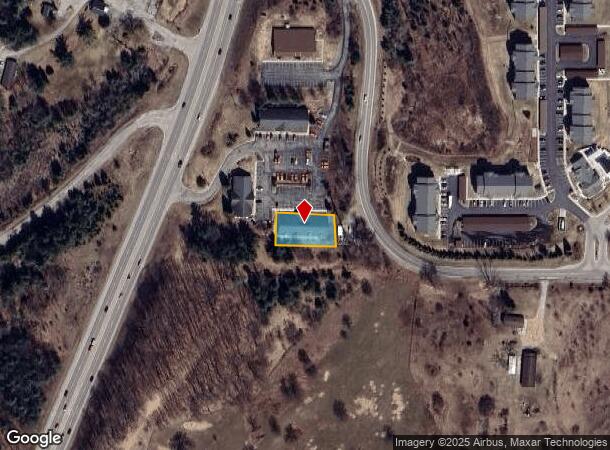
2040 N Us Highway 31 S, Traverse City, MI 49685
NEARBY LISTINGS FOR SALE OR LEASE
Property Detail
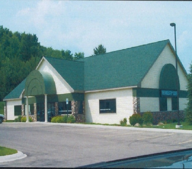
2040 N Us Highway 31 S
05-136-003-00
Hartman Hills Marketplace
Commercialcondominium
UNIT 3 HARTMAN HILLS MARKETPLACE CONDO GT CO CONDO PLAN NO 105 LIBER 1269 PAGES 496-532
X
Grand Traverse
26055C0225C
Michigan
2024
1.42 AC
2025
Michigan Northwest Area
550602
Other Market Areas
7,476 SF
Traverse City, MI
DEMOGRAPHICS near 2040 N Us Highway 31 S
1 Mile
3 Mile
5 Mile
2024 Total Population
1,755
23,008
49,179
2029 Population
1,839
23,693
50,742
Pop Growth 2024-2029
+ 4.79%
+ 2.98%
+ 3.18%
Average Age
41
43
43
2024 Total Households
913
10,425
21,555
HH Growth 2024-2029
+ 4.93%
+ 2.97%
+ 3.17%
Median Household Inc
$50,042
$52,963
$60,687
Avg Household Size
1.90
2.10
2.20
2024 Avg HH Vehicles
1.00
2.00
2.00
Median Home Value
$265,530
$254,374
$277,945
Median Year Built
2005
1990
1984
Nearby Places
Map Layers
Map Styles
 Street
 Aerial
- Restaurants
- Banks
- Shops
- Fitness
- Groceries
PUBLIC TRANSPORTATION
AIRPORT
Cherry Capital
DRIVE
WALK
Distance
Cherry Capital
17 min
6.6 mi
Freight Ports
Port Milwaukee
DRIVE
WALK
Distance
Port Milwaukee
459 min
403.1 mi
Nearby Properties
Address
Land Use
TOTAL SIZE
Lot Size
Zoning
Address
Land Use
TOTAL SIZE
Lot Size
Zoning
280,377 SF
99.37 AC
Address
Land Use
TOTAL SIZE
Lot Size
Zoning
Address
Land Use
TOTAL SIZE
Lot Size
Zoning
64,783 SF
18.56 AC
Address
Land Use
TOTAL SIZE
Lot Size
Zoning
24,879 SF
19.31 AC
Address
Land Use
TOTAL SIZE
Lot Size
Zoning
192,931 SF
75.10 AC
Address
Land Use
TOTAL SIZE
Lot Size
Zoning
41,084 SF
22.79 AC
Address
Land Use
TOTAL SIZE
Lot Size
Zoning
243,935 SF
28.83 AC
Address
Land Use
TOTAL SIZE
Lot Size
Zoning
257,342 SF
25.11 AC
Address
Land Use
TOTAL SIZE
Lot Size
Zoning
25,208 SF
15.01 AC
Address
Land Use
TOTAL SIZE
Lot Size
Zoning
28,864 SF
20.26 AC
Address
Land Use
TOTAL SIZE
Lot Size
Zoning
131,040 SF
22.23 AC
Address
Land Use
TOTAL SIZE
Lot Size
Zoning
42,598 SF
2.81 AC
Address
Land Use
TOTAL SIZE
Lot Size
Zoning
6,354 SF
97.88 AC
Address
Land Use
TOTAL SIZE
Lot Size
Zoning
28,864 SF
14.43 AC
Address
Land Use
TOTAL SIZE
Lot Size
Zoning
420,291 SF
41.91 AC
Address
Land Use
TOTAL SIZE
Lot Size
Zoning
83,925 SF
20.69 AC
Address
Land Use
TOTAL SIZE
Lot Size
Zoning
4,000 SF
104.55 AC
Address
Land Use
TOTAL SIZE
Lot Size
Zoning
8,820 SF
15.24 AC
Address
Land Use
TOTAL SIZE
Lot Size
Zoning
28,620 SF
3.86 AC
Address
Land Use
TOTAL SIZE
Lot Size
Zoning
136,197 SF
62.59 AC
Address
Land Use
TOTAL SIZE
Lot Size
Zoning
78,933 SF
19.79 AC
Address
Land Use
TOTAL SIZE
Lot Size
Zoning
17,892 SF
18.28 AC
Address
Land Use
TOTAL SIZE
Lot Size
Zoning
2,216 SF
7.48 AC
Address
Land Use
TOTAL SIZE
Lot Size
Zoning
74,411 SF
28.31 AC
Address
Land Use
TOTAL SIZE
Lot Size
Zoning
105,570 SF
16.65 AC
Address
Land Use
TOTAL SIZE
Lot Size
Zoning
43,100 SF
10.29 AC
Address
Land Use
TOTAL SIZE
Lot Size
Zoning
1,276 SF
5.73 AC
Address
Land Use
TOTAL SIZE
Lot Size
Zoning
92,450 SF
5.71 AC
Address
Land Use
TOTAL SIZE
Lot Size
Zoning
14,592 SF
12.79 AC
Address
Land Use
TOTAL SIZE
Lot Size
Zoning
54,094 SF
7.02 AC
The World's #1 Commercial Real Estate Marketplace
Connect with us
© 2025 CoStar Group
The information above has been obtained from sources believed reliable. While we do not doubt its accuracy we have not verified it and make no guarantee, warranty or representation about it. It is your responsibility to independently confirm its accuracy and completeness. Any projections, opinions, assumptions, or estimates used are for example only and do not represent the current or future performance of the property. The value of this transaction to you depends on tax and other factors which should be evaluated by your tax, financial, and legal advisors. You and your advisors should conduct a careful, independent investigation of the property to determine to your satisfaction the suitability of the property for your needs.