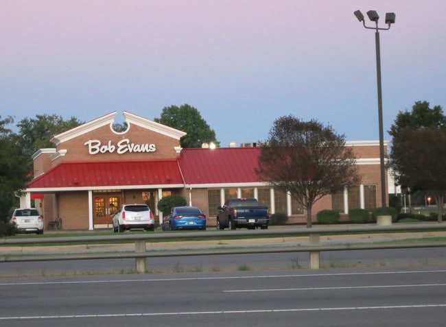
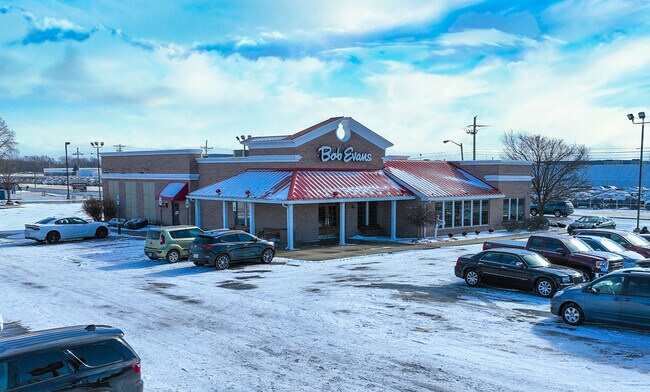
Property Record
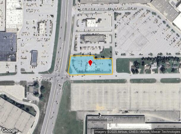
2040 S Reed Rd, Kokomo, IN 46902
NEARBY LISTINGS FOR SALE OR LEASE
Property Detail
2040 S Reed Rd
Kokomo, IN
Bob Evans Farms Minor Sub
34-10-05-351-018.000-002
BOB EVANS FARMS MINOR S/D LOT 1 1.73 AC NET
Restaurantdrivein
Howard
X
Indiana
18067C0228C
1
2024
1.73 AC
2025
Lafayette/Kokomo
001300
Other Market Areas
5,606 SF
DEMOGRAPHICS near 2040 S Reed Rd
1 Mile
3 Mile
5 Mile
2024 Total Population
5,212
43,040
67,539
2029 Population
5,177
43,305
67,632
Pop Growth 2024-2029
(0.67%)
+ 0.62%
+ 0.14%
Average Age
41
41
42
2024 Total Households
2,504
19,185
29,405
HH Growth 2024-2029
(0.76%)
+ 0.63%
+ 0.09%
Median Household Inc
$42,189
$47,657
$52,603
Avg Household Size
2.10
2.20
2.20
2024 Avg HH Vehicles
2.00
2.00
2.00
Median Home Value
$116,443
$116,128
$133,382
Median Year Built
1967
1964
1966
Nearby Places
Map Layers
Map Styles
 Street
 Aerial
- Restaurants
- Banks
- Shops
- Fitness
- Groceries
SALE & LEASE HISTORY
LISTING DATE
SALE/LEASE

Feb 09, 2022
For Sale
Dec 28, 2017
For Sale
Nearby Properties
Address
Land Use
TOTAL SIZE
Lot Size
Zoning
Address
Land Use
TOTAL SIZE
Lot Size
Zoning
195,620 SF
145.92 AC
Address
Land Use
TOTAL SIZE
Lot Size
Zoning
167,374 SF
17.75 AC
Address
Land Use
TOTAL SIZE
Lot Size
Zoning
263,087 SF
37.71 AC
Address
Land Use
TOTAL SIZE
Lot Size
Zoning
148,184 SF
21.53 AC
Address
Land Use
TOTAL SIZE
Lot Size
Zoning
21,318 SF
22.30 AC
Address
Land Use
TOTAL SIZE
Lot Size
Zoning
38,390 SF
1.97 AC
Address
Land Use
TOTAL SIZE
Lot Size
Zoning
1,059,394 SF
151.44 AC
Address
Land Use
TOTAL SIZE
Lot Size
Zoning
126,690 SF
23.75 AC
Address
Land Use
TOTAL SIZE
Lot Size
Zoning
123,984 SF
24.89 AC
Address
Land Use
TOTAL SIZE
Lot Size
Zoning
11,936 SF
1.18 AC
Address
Land Use
TOTAL SIZE
Lot Size
Zoning
9,710 SF
3 AC
Address
Land Use
TOTAL SIZE
Lot Size
Zoning
49,809 SF
8.51 AC
Address
Land Use
TOTAL SIZE
Lot Size
Zoning
15,043 SF
1.59 AC
Address
Land Use
TOTAL SIZE
Lot Size
Zoning
35,931 SF
16.63 AC
Address
Land Use
TOTAL SIZE
Lot Size
Zoning
5,732 SF
10.96 AC
Address
Land Use
TOTAL SIZE
Lot Size
Zoning
188,016 SF
13.15 AC
Address
Land Use
TOTAL SIZE
Lot Size
Zoning
83,797 SF
8.42 AC
Address
Land Use
TOTAL SIZE
Lot Size
Zoning
114,601 SF
14.02 AC
Address
Land Use
TOTAL SIZE
Lot Size
Zoning
45,174 SF
7.77 AC
Address
Land Use
TOTAL SIZE
Lot Size
Zoning
9,158 SF
10.56 AC
Address
Land Use
TOTAL SIZE
Lot Size
Zoning
215,028 SF
65.23 AC
Address
Land Use
TOTAL SIZE
Lot Size
Zoning
76,576 SF
7.98 AC
Address
Land Use
TOTAL SIZE
Lot Size
Zoning
11,634 SF
3.73 AC
Address
Land Use
TOTAL SIZE
Lot Size
Zoning
75,440 SF
19.08 AC
Address
Land Use
TOTAL SIZE
Lot Size
Zoning
39,054 SF
14.71 AC
Address
Land Use
TOTAL SIZE
Lot Size
Zoning
28,188 SF
13.49 AC
Address
Land Use
TOTAL SIZE
Lot Size
Zoning
81,291 SF
20.58 AC
Address
Land Use
TOTAL SIZE
Lot Size
Zoning
125,267 SF
15.21 AC
Address
Land Use
TOTAL SIZE
Lot Size
Zoning
65,508 SF
20.65 AC
Address
Land Use
TOTAL SIZE
Lot Size
Zoning
14,926 SF
3.01 AC
The World's #1 Commercial Real Estate Marketplace
Connect with us
© 2026 CoStar Group
The information above has been obtained from sources believed reliable. While we do not doubt its accuracy we have not verified it and make no guarantee, warranty or representation about it. It is your responsibility to independently confirm its accuracy and completeness. Any projections, opinions, assumptions, or estimates used are for example only and do not represent the current or future performance of the property. The value of this transaction to you depends on tax and other factors which should be evaluated by your tax, financial, and legal advisors. You and your advisors should conduct a careful, independent investigation of the property to determine to your satisfaction the suitability of the property for your needs.