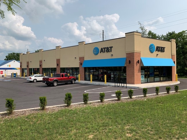
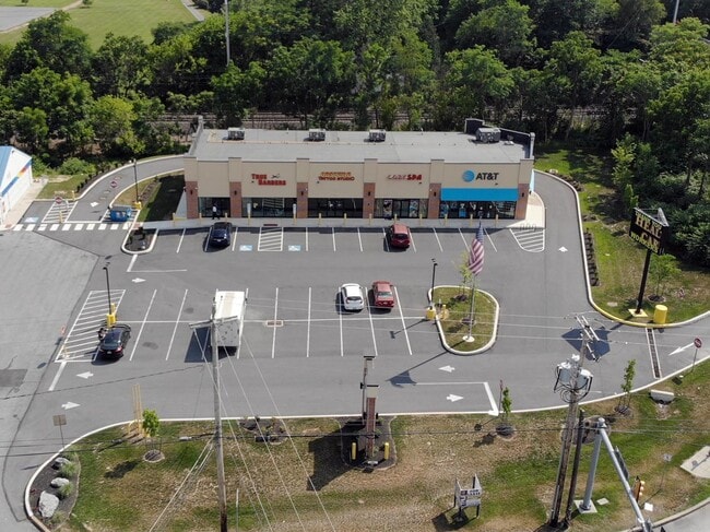
Property Record
2040 W Main St, Mount Joy, PA 17552

NEARBY LISTINGS FOR SALE OR LEASE
Property Detail
2040 W Main St
461-02867-0-0000
Prepared For The Sico Company
Storebuilding
Lancaster
X
Pennsylvania
42071C0114F
1.79 AC
2024
Lancaster County
2025
Philadelphia
010602
Lancaster, PA
9,098 SF
DEMOGRAPHICS near 2040 W Main St
1 Mile
3 Mile
5 Mile
2024 Total Population
4,061
27,101
54,324
2029 Population
4,057
27,319
54,789
Pop Growth 2024-2029
(0.10%)
+ 0.80%
+ 0.86%
Average Age
40
40
42
2024 Total Households
1,518
10,453
21,443
HH Growth 2024-2029
(0.13%)
+ 0.97%
+ 0.97%
Median Household Inc
$90,744
$75,565
$77,751
Avg Household Size
2.60
2.40
2.40
2024 Avg HH Vehicles
2.00
2.00
2.00
Median Home Value
$246,651
$243,820
$251,096
Median Year Built
1989
1980
1986
Nearby Places
Map Layers
Map Styles
 Street
 Aerial
- Restaurants
- Banks
- Shops
- Fitness
- Groceries
PUBLIC TRANSPORTATION
COMMUTER RAIL
DRIVE
WALK
Distance
6 min
3.3 mi
DRIVE
WALK
Distance
6 min
3.6 mi
AIRPORT
Harrisburg International
DRIVE
WALK
Distance
Harrisburg International
24 min
17.2 mi
Freight Ports
Port Newark Container Terminal
DRIVE
WALK
Distance
Port Newark Container Terminal
101 min
65.4 mi
SALE & LEASE HISTORY
LISTING DATE
SALE/LEASE

May 22, 2020
For Lease
Dec 02, 2019
For Lease
Nearby Properties
Address
Land Use
TOTAL SIZE
Lot Size
Zoning
Address
Land Use
TOTAL SIZE
Lot Size
Zoning
531,244 SF
100.20 AC
Address
Land Use
TOTAL SIZE
Lot Size
Zoning
705,686 SF
90.80 AC
Address
Land Use
TOTAL SIZE
Lot Size
Zoning
463,991 SF
89.23 AC
Address
Land Use
TOTAL SIZE
Lot Size
Zoning
218,686 SF
6.79 AC
MU
Address
Land Use
TOTAL SIZE
Lot Size
Zoning
154,112 SF
18.92 AC
Address
Land Use
TOTAL SIZE
Lot Size
Zoning
200,892 SF
16.25 AC
R3
Address
Land Use
TOTAL SIZE
Lot Size
Zoning
441,646 SF
59.55 AC
I-2
Address
Land Use
TOTAL SIZE
Lot Size
Zoning
85,268 SF
34.90 AC
Address
Land Use
TOTAL SIZE
Lot Size
Zoning
138,828 SF
17.09 AC
Address
Land Use
TOTAL SIZE
Lot Size
Zoning
120,757 SF
3 AC
TN
Address
Land Use
TOTAL SIZE
Lot Size
Zoning
91,050 SF
30.10 AC
MHDR
Address
Land Use
TOTAL SIZE
Lot Size
Zoning
495,816 SF
26.02 AC
I-G
Address
Land Use
TOTAL SIZE
Lot Size
Zoning
3,672 SF
176 AC
A
Address
Land Use
TOTAL SIZE
Lot Size
Zoning
4,160 SF
101.10 AC
A
Address
Land Use
TOTAL SIZE
Lot Size
Zoning
37,911 SF
14.40 AC
RT
Address
Land Use
TOTAL SIZE
Lot Size
Zoning
41,069 SF
3.12 AC
R1
Address
Land Use
TOTAL SIZE
Lot Size
Zoning
46,890 SF
1 AC
MDR
Address
Land Use
TOTAL SIZE
Lot Size
Zoning
61,504 SF
6.64 AC
Address
Land Use
TOTAL SIZE
Lot Size
Zoning
61,606 SF
14.60 AC
A
Address
Land Use
TOTAL SIZE
Lot Size
Zoning
71,425 SF
1 AC
TN
Address
Land Use
TOTAL SIZE
Lot Size
Zoning
71,326 SF
1 AC
TN
Address
Land Use
TOTAL SIZE
Lot Size
Zoning
44,610 SF
10.58 AC
R-2
Address
Land Use
TOTAL SIZE
Lot Size
Zoning
160,545 SF
9.54 AC
C-G
Address
Land Use
TOTAL SIZE
Lot Size
Zoning
Address
Land Use
TOTAL SIZE
Lot Size
Zoning
50,140 SF
0.73 AC
CBD
Address
Land Use
TOTAL SIZE
Lot Size
Zoning
47,082 SF
5.30 AC
Address
Land Use
TOTAL SIZE
Lot Size
Zoning
24,282 SF
4.35 AC
INS
Address
Land Use
TOTAL SIZE
Lot Size
Zoning
40,468 SF
4.08 AC
Address
Land Use
TOTAL SIZE
Lot Size
Zoning
44,696 SF
4.79 AC
R-3
Address
Land Use
TOTAL SIZE
Lot Size
Zoning
23,763 SF
13 AC
The World's #1 Commercial Real Estate Marketplace
Connect with us
© 2025 CoStar Group
The information above has been obtained from sources believed reliable. While we do not doubt its accuracy we have not verified it and make no guarantee, warranty or representation about it. It is your responsibility to independently confirm its accuracy and completeness. Any projections, opinions, assumptions, or estimates used are for example only and do not represent the current or future performance of the property. The value of this transaction to you depends on tax and other factors which should be evaluated by your tax, financial, and legal advisors. You and your advisors should conduct a careful, independent investigation of the property to determine to your satisfaction the suitability of the property for your needs.