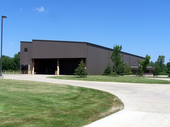
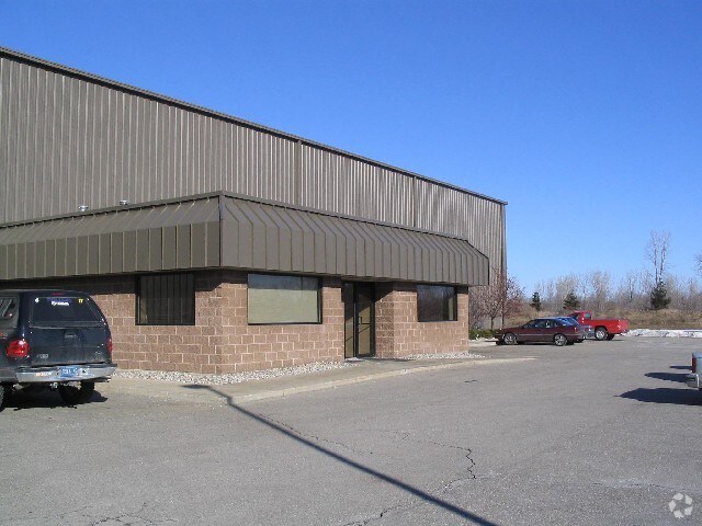
Property Record
2040 W Thompson Rd, Fenton, MI 48430
NEARBY LISTINGS FOR SALE OR LEASE
Property Detail
2040 W Thompson Rd
Flint, MI
A PARCEL OF LAND BEG N 01 DEG 40 MIN 18 SEC W 659.55 FT FROM E 1/4 COR OF SEC TH S 87 DEG 15 MIN 36 SEC W 660.11 FT TH N 01
06-02-200-029
Genesee
Industrialgeneral
Michigan
2024
10.12 AC
2025
Flint
013302
Detroit
25,200 SF
DEMOGRAPHICS near 2040 W Thompson Rd
1 Mile
3 Mile
5 Mile
2024 Total Population
1,492
11,150
39,215
2029 Population
1,444
10,904
38,356
Pop Growth 2024-2029
(3.22%)
(2.21%)
(2.19%)
Average Age
42
43
42
2024 Total Households
586
4,402
16,360
HH Growth 2024-2029
(3.24%)
(2.25%)
(2.24%)
Median Household Inc
$110,714
$105,362
$80,547
Avg Household Size
2.50
2.50
2.30
2024 Avg HH Vehicles
2.00
2.00
2.00
Median Home Value
$300,633
$295,945
$247,942
Median Year Built
1987
1991
1987
Nearby Places
Map Layers
Map Styles
 Street
 Aerial
- Restaurants
- Banks
- Shops
- Fitness
- Groceries
PUBLIC TRANSPORTATION
AIRPORT
Bishop International
DRIVE
WALK
Distance
Bishop International
25 min
10.8 mi
Nearby Properties
Address
Land Use
TOTAL SIZE
Lot Size
Zoning
Address
Land Use
TOTAL SIZE
Lot Size
Zoning
135,840 SF
PUD
Address
Land Use
TOTAL SIZE
Lot Size
Zoning
752,146 SF
100 AC
RA
Address
Land Use
TOTAL SIZE
Lot Size
Zoning
104,867 SF
PERSONA
Address
Land Use
TOTAL SIZE
Lot Size
Zoning
754 SF
15.74 AC
PUD
Address
Land Use
TOTAL SIZE
Lot Size
Zoning
53,951 SF
8.08 AC
M-1
Address
Land Use
TOTAL SIZE
Lot Size
Zoning
17.96 AC
PUD
Address
Land Use
TOTAL SIZE
Lot Size
Zoning
28.12 AC
R-MH
Address
Land Use
TOTAL SIZE
Lot Size
Zoning
37,288 SF
6.59 AC
C-3
Address
Land Use
TOTAL SIZE
Lot Size
Zoning
56,406 SF
7.15 AC
M-1
Address
Land Use
TOTAL SIZE
Lot Size
Zoning
31,768 SF
3.26 AC
M-2
Address
Land Use
TOTAL SIZE
Lot Size
Zoning
40,500 SF
4.74 AC
C-3
Address
Land Use
TOTAL SIZE
Lot Size
Zoning
63,098 SF
9.06 AC
M-2
Address
Land Use
TOTAL SIZE
Lot Size
Zoning
35,813 SF
14.31 AC
M-1
Address
Land Use
TOTAL SIZE
Lot Size
Zoning
6,091 SF
69.80 AC
R1
Address
Land Use
TOTAL SIZE
Lot Size
Zoning
10,308 SF
142.37 AC
R-3
Address
Land Use
TOTAL SIZE
Lot Size
Zoning
162.87 AC
RE
Address
Land Use
TOTAL SIZE
Lot Size
Zoning
16,000 SF
5.08 AC
M-2
Address
Land Use
TOTAL SIZE
Lot Size
Zoning
19,456 SF
1.26 AC
C-2
Address
Land Use
TOTAL SIZE
Lot Size
Zoning
5,600 SF
77.96 AC
AG
Address
Land Use
TOTAL SIZE
Lot Size
Zoning
1,436 SF
81.93 AC
AG
Address
Land Use
TOTAL SIZE
Lot Size
Zoning
19,272 SF
40 AC
RA
Address
Land Use
TOTAL SIZE
Lot Size
Zoning
5,281 SF
1.82 AC
C-3
Address
Land Use
TOTAL SIZE
Lot Size
Zoning
576 SF
28.26 AC
C-3
Address
Land Use
TOTAL SIZE
Lot Size
Zoning
3,548 SF
AG
Address
Land Use
TOTAL SIZE
Lot Size
Zoning
7,424 SF
0.46 AC
C-2
Address
Land Use
TOTAL SIZE
Lot Size
Zoning
10,874 SF
1.83 AC
R-6
Address
Land Use
TOTAL SIZE
Lot Size
Zoning
2,316 SF
135.18 AC
RA
Address
Land Use
TOTAL SIZE
Lot Size
Zoning
3,217 SF
84.96 AC
RA
Address
Land Use
TOTAL SIZE
Lot Size
Zoning
5,376 SF
56.83 AC
RSA
The World's #1 Commercial Real Estate Marketplace
Connect with us
© 2025 CoStar Group
The information above has been obtained from sources believed reliable. While we do not doubt its accuracy we have not verified it and make no guarantee, warranty or representation about it. It is your responsibility to independently confirm its accuracy and completeness. Any projections, opinions, assumptions, or estimates used are for example only and do not represent the current or future performance of the property. The value of this transaction to you depends on tax and other factors which should be evaluated by your tax, financial, and legal advisors. You and your advisors should conduct a careful, independent investigation of the property to determine to your satisfaction the suitability of the property for your needs.