Property Record
2040 Wales Ave Nw, Massillon, OH 44646


NEARBY LISTINGS FOR SALE OR LEASE
Property Detail
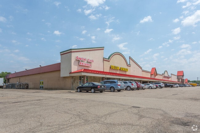
2040 Wales Ave Nw
00800039
Perry Sec 04
Regionalshoppingcenterormallwithanchorstore
OL 853 - 8.43A
X
Stark
39151C0184E
Ohio
0
8.43 AC
2025
Stark County
713501
Cleveland
116,926 SF
Canton-Massillon, OH
DEMOGRAPHICS near 2040 Wales Ave Nw
1 Mile
3 Mile
5 Mile
2024 Total Population
8,904
49,484
107,091
2029 Population
8,787
48,996
106,149
Pop Growth 2024-2029
(1.31%)
(0.99%)
(0.88%)
Average Age
43
42
43
2024 Total Households
3,985
20,990
45,791
HH Growth 2024-2029
(1.38%)
(1.03%)
(0.90%)
Median Household Inc
$57,921
$60,314
$63,881
Avg Household Size
2.20
2.30
2.30
2024 Avg HH Vehicles
2.00
2.00
2.00
Median Home Value
$165,404
$160,788
$166,551
Median Year Built
1972
1968
1968
Nearby Places
Map Layers
Map Styles
 Street
 Aerial
- Restaurants
- Banks
- Shops
- Fitness
- Groceries
PUBLIC TRANSPORTATION
AIRPORT
Akron-Canton Regional
DRIVE
WALK
Distance
Akron-Canton Regional
17 min
9.3 mi
Freight Ports
Port of Toledo
DRIVE
WALK
Distance
Port of Toledo
181 min
152.9 mi
SALE & LEASE HISTORY
LISTING DATE
SALE/LEASE

Sep 24, 2016
For Sale
Aug 18, 2017
For Lease
Aug 18, 2017
For Sale
Nearby Properties
Address
Land Use
TOTAL SIZE
Lot Size
Zoning
Address
Land Use
TOTAL SIZE
Lot Size
Zoning
491,571 SF
152.10 AC
Address
Land Use
TOTAL SIZE
Lot Size
Zoning
417,003 SF
35.79 AC
Address
Land Use
TOTAL SIZE
Lot Size
Zoning
276,484 SF
21.51 AC
Address
Land Use
TOTAL SIZE
Lot Size
Zoning
175,847 SF
31.71 AC
Address
Land Use
TOTAL SIZE
Lot Size
Zoning
290,926 SF
43.11 AC
Address
Land Use
TOTAL SIZE
Lot Size
Zoning
143,920 SF
18.49 AC
Address
Land Use
TOTAL SIZE
Lot Size
Zoning
68,518 SF
9.27 AC
Address
Land Use
TOTAL SIZE
Lot Size
Zoning
96,277 SF
13.51 AC
Address
Land Use
TOTAL SIZE
Lot Size
Zoning
64,985 SF
7.11 AC
Address
Land Use
TOTAL SIZE
Lot Size
Zoning
55,216 SF
4.21 AC
Address
Land Use
TOTAL SIZE
Lot Size
Zoning
246,618 SF
11.30 AC
Address
Land Use
TOTAL SIZE
Lot Size
Zoning
59,337 SF
5.99 AC
Address
Land Use
TOTAL SIZE
Lot Size
Zoning
57,592 SF
9.57 AC
Address
Land Use
TOTAL SIZE
Lot Size
Zoning
103,903 SF
15.02 AC
Address
Land Use
TOTAL SIZE
Lot Size
Zoning
49,837 SF
54.94 AC
Address
Land Use
TOTAL SIZE
Lot Size
Zoning
118,943 SF
10.51 AC
Address
Land Use
TOTAL SIZE
Lot Size
Zoning
107,826 SF
8.76 AC
Address
Land Use
TOTAL SIZE
Lot Size
Zoning
63,324 SF
5.93 AC
Address
Land Use
TOTAL SIZE
Lot Size
Zoning
47,050 SF
3.58 AC
Address
Land Use
TOTAL SIZE
Lot Size
Zoning
81,393 SF
24.88 AC
Address
Land Use
TOTAL SIZE
Lot Size
Zoning
67,056 SF
1.91 AC
Address
Land Use
TOTAL SIZE
Lot Size
Zoning
42,372 SF
6.74 AC
Address
Land Use
TOTAL SIZE
Lot Size
Zoning
82,413 SF
15.62 AC
Address
Land Use
TOTAL SIZE
Lot Size
Zoning
79,092 SF
1.29 AC
Address
Land Use
TOTAL SIZE
Lot Size
Zoning
139,720 SF
9.51 AC
Address
Land Use
TOTAL SIZE
Lot Size
Zoning
96,944 SF
12.84 AC
Address
Land Use
TOTAL SIZE
Lot Size
Zoning
48,994 SF
4.39 AC
Address
Land Use
TOTAL SIZE
Lot Size
Zoning
67,011 SF
17.58 AC
Address
Land Use
TOTAL SIZE
Lot Size
Zoning
69,880 SF
1.27 AC
Address
Land Use
TOTAL SIZE
Lot Size
Zoning
120,655 SF
8.39 AC
The World's #1 Commercial Real Estate Marketplace
Connect with us
© 2025 CoStar Group
The information above has been obtained from sources believed reliable. While we do not doubt its accuracy we have not verified it and make no guarantee, warranty or representation about it. It is your responsibility to independently confirm its accuracy and completeness. Any projections, opinions, assumptions, or estimates used are for example only and do not represent the current or future performance of the property. The value of this transaction to you depends on tax and other factors which should be evaluated by your tax, financial, and legal advisors. You and your advisors should conduct a careful, independent investigation of the property to determine to your satisfaction the suitability of the property for your needs.