Property Record
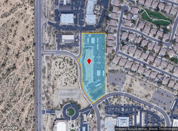
20401 N 73Rd St, Scottsdale, AZ 85255

Current Lease Availabilities
NEARBY LISTINGS FOR SALE OR LEASE
Property Detail
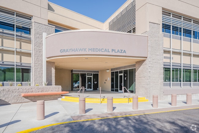
20401 N 73Rd St
Phoenix-Mesa-Scottsdale, AZ
State Plat No 27 Amd Core North First Am
212-31-163M
STATE PLAT NO 27 AMD CORE NORTH FIRST AMD MCR 395-21
Medicalbuilding
Maricopa
X
Arizona
04013C1320L
b
2025
4.36 AC
2025
Scottsdale Airpark
216842
Phoenix
47,102 SF
DEMOGRAPHICS near 20401 N 73Rd St
1 Mile
3 Mile
5 Mile
2024 Total Population
7,341
48,615
150,071
2029 Population
8,096
53,797
164,653
Pop Growth 2024-2029
+ 10.28%
+ 10.66%
+ 9.72%
Average Age
46
45
43
2024 Total Households
3,653
22,922
64,941
HH Growth 2024-2029
+ 10.76%
+ 11.06%
+ 10.06%
Median Household Inc
$116,539
$114,475
$116,213
Avg Household Size
2.00
2.10
2.30
2024 Avg HH Vehicles
2.00
2.00
2.00
Median Home Value
$688,910
$720,408
$675,830
Median Year Built
2001
2000
1996
Nearby Places
Map Layers
Map Styles
 Street
 Aerial
- Restaurants
- Banks
- Shops
- Fitness
- Groceries
PUBLIC TRANSPORTATION
AIRPORT
Phoenix Sky Harbor International
DRIVE
WALK
Distance
Phoenix Sky Harbor International
34 min
25.1 mi
Phoenix-Mesa Gateway
DRIVE
WALK
Distance
Phoenix-Mesa Gateway
54 min
40.1 mi
Freight Ports
Port of San Diego
DRIVE
WALK
Distance
Port of San Diego
421 min
377.2 mi
Nearby Properties
Address
Land Use
TOTAL SIZE
Lot Size
Zoning
Address
Land Use
TOTAL SIZE
Lot Size
Zoning
1,504,047 SF
40.43 AC
I-P
Address
Land Use
TOTAL SIZE
Lot Size
Zoning
20.98 AC
Address
Land Use
TOTAL SIZE
Lot Size
Zoning
13.01 AC
Address
Land Use
TOTAL SIZE
Lot Size
Zoning
35.76 AC
R1-18
Address
Land Use
TOTAL SIZE
Lot Size
Zoning
14.58 AC
Address
Land Use
TOTAL SIZE
Lot Size
Zoning
1,479,005 SF
12.55 AC
PC
Address
Land Use
TOTAL SIZE
Lot Size
Zoning
1,162,283 SF
115.23 AC
C-C
Address
Land Use
TOTAL SIZE
Lot Size
Zoning
Address
Land Use
TOTAL SIZE
Lot Size
Zoning
Address
Land Use
TOTAL SIZE
Lot Size
Zoning
694,644 SF
34.41 AC
C-C
Address
Land Use
TOTAL SIZE
Lot Size
Zoning
670,926 SF
20.92 AC
I-P
Address
Land Use
TOTAL SIZE
Lot Size
Zoning
229,856 SF
7.71 AC
C-T
Address
Land Use
TOTAL SIZE
Lot Size
Zoning
762,044 SF
16.66 AC
I1
Address
Land Use
TOTAL SIZE
Lot Size
Zoning
368,657 SF
40.11 AC
Address
Land Use
TOTAL SIZE
Lot Size
Zoning
514,088 SF
6.70 AC
PAD
Address
Land Use
TOTAL SIZE
Lot Size
Zoning
734,840 SF
33.12 AC
M-H
Address
Land Use
TOTAL SIZE
Lot Size
Zoning
707,542 SF
28.49 AC
R-3A
Address
Land Use
TOTAL SIZE
Lot Size
Zoning
421,002 SF
23.48 AC
Address
Land Use
TOTAL SIZE
Lot Size
Zoning
487,786 SF
18.42 AC
S1
Address
Land Use
TOTAL SIZE
Lot Size
Zoning
884,258 SF
30.63 AC
PCD
Address
Land Use
TOTAL SIZE
Lot Size
Zoning
90.73 AC
O-S
Address
Land Use
TOTAL SIZE
Lot Size
Zoning
497,704 SF
6.77 AC
Address
Land Use
TOTAL SIZE
Lot Size
Zoning
539,135 SF
15.11 AC
R3A
Address
Land Use
TOTAL SIZE
Lot Size
Zoning
530,588 SF
20.58 AC
C-C
Address
Land Use
TOTAL SIZE
Lot Size
Zoning
495,877 SF
21.08 AC
C-C
Address
Land Use
TOTAL SIZE
Lot Size
Zoning
525,073 SF
8.51 AC
R4
Address
Land Use
TOTAL SIZE
Lot Size
Zoning
255,313 SF
22.54 AC
PNC
Address
Land Use
TOTAL SIZE
Lot Size
Zoning
385,376 SF
13.65 AC
PAD
Address
Land Use
TOTAL SIZE
Lot Size
Zoning
702,652 SF
4.58 AC
Address
Land Use
TOTAL SIZE
Lot Size
Zoning
213,012 SF
23.11 AC
PRC
The World's #1 Commercial Real Estate Marketplace
Connect with us
© 2025 CoStar Group
The information above has been obtained from sources believed reliable. While we do not doubt its accuracy we have not verified it and make no guarantee, warranty or representation about it. It is your responsibility to independently confirm its accuracy and completeness. Any projections, opinions, assumptions, or estimates used are for example only and do not represent the current or future performance of the property. The value of this transaction to you depends on tax and other factors which should be evaluated by your tax, financial, and legal advisors. You and your advisors should conduct a careful, independent investigation of the property to determine to your satisfaction the suitability of the property for your needs.