Property Record
2041 Camp Swatara Rd, Myerstown, PA 17067
NEARBY LISTINGS FOR SALE OR LEASE
-
-
View all Myerstown listings for sale on LoopNet.com
Property Detail
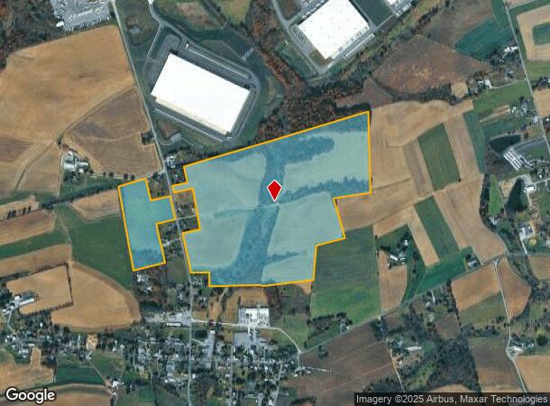
2041 Camp Swatara Rd
30-3491-18-41-7657
Berks
Recreationalacreage
Pennsylvania
AE
5&adj
42011C0279G
101.82 AC
2025
Berks County
2025
Philadelphia
010100
Reading, PA
DEMOGRAPHICS near 2041 Camp Swatara Rd
1 Mile
3 Mile
5 Mile
2024 Total Population
494
4,134
11,531
2029 Population
495
4,131
11,561
Pop Growth 2024-2029
+ 0.20%
(0.07%)
+ 0.26%
Average Age
38
39
40
2024 Total Households
167
1,399
4,048
HH Growth 2024-2029
+ 0.60%
(0.07%)
+ 0.35%
Median Household Inc
$78,906
$83,533
$86,177
Avg Household Size
2.80
2.90
2.80
2024 Avg HH Vehicles
3.00
3.00
2.00
Median Home Value
$263,953
$268,269
$243,843
Median Year Built
1972
1975
1981
Nearby Places
Map Layers
Map Styles
 Street
 Aerial
- Restaurants
- Banks
- Shops
- Fitness
- Groceries
PUBLIC TRANSPORTATION
AIRPORT
Harrisburg International
DRIVE
WALK
Distance
Harrisburg International
53 min
41.1 mi
Freight Ports
Port of Wilmington, RI
DRIVE
WALK
Distance
Port of Wilmington, RI
121 min
83.4 mi
SALE & LEASE HISTORY
LISTING DATE
SALE/LEASE

Sep 24, 2016
For Sale
Feb 17, 2017
For Sale
Nearby Properties
Address
Land Use
TOTAL SIZE
Lot Size
Zoning
Address
Land Use
TOTAL SIZE
Lot Size
Zoning
912,018 SF
110.86 AC
Address
Land Use
TOTAL SIZE
Lot Size
Zoning
1,069,500 SF
87.86 AC
Address
Land Use
TOTAL SIZE
Lot Size
Zoning
615,600 SF
42.43 AC
Address
Land Use
TOTAL SIZE
Lot Size
Zoning
832,000 SF
68.04 AC
Address
Land Use
TOTAL SIZE
Lot Size
Zoning
750,000 SF
89.22 AC
Address
Land Use
TOTAL SIZE
Lot Size
Zoning
1,008,647 SF
71.74 AC
Address
Land Use
TOTAL SIZE
Lot Size
Zoning
276,800 SF
27.97 AC
Address
Land Use
TOTAL SIZE
Lot Size
Zoning
40,675 SF
56.71 AC
Address
Land Use
TOTAL SIZE
Lot Size
Zoning
201,000 SF
17.72 AC
Address
Land Use
TOTAL SIZE
Lot Size
Zoning
47,480 SF
11.68 AC
Address
Land Use
TOTAL SIZE
Lot Size
Zoning
19,520 SF
4.14 AC
Address
Land Use
TOTAL SIZE
Lot Size
Zoning
49,584 SF
18.61 AC
Address
Land Use
TOTAL SIZE
Lot Size
Zoning
6,824 SF
3.38 AC
Address
Land Use
TOTAL SIZE
Lot Size
Zoning
28,548 SF
3.46 AC
Address
Land Use
TOTAL SIZE
Lot Size
Zoning
19,911 SF
7.92 AC
Address
Land Use
TOTAL SIZE
Lot Size
Zoning
34,478 SF
19.36 AC
Address
Land Use
TOTAL SIZE
Lot Size
Zoning
11,160 SF
20.50 AC
Address
Land Use
TOTAL SIZE
Lot Size
Zoning
8,448 SF
5.49 AC
Address
Land Use
TOTAL SIZE
Lot Size
Zoning
3,244 SF
1.79 AC
Address
Land Use
TOTAL SIZE
Lot Size
Zoning
14,600 SF
15.13 AC
Address
Land Use
TOTAL SIZE
Lot Size
Zoning
20,266 SF
3.45 AC
Address
Land Use
TOTAL SIZE
Lot Size
Zoning
5,945 SF
46.35 AC
Address
Land Use
TOTAL SIZE
Lot Size
Zoning
7,244 SF
2.74 AC
Address
Land Use
TOTAL SIZE
Lot Size
Zoning
31,340 SF
9.53 AC
Address
Land Use
TOTAL SIZE
Lot Size
Zoning
23,024 SF
4.32 AC
Address
Land Use
TOTAL SIZE
Lot Size
Zoning
4.01 AC
Address
Land Use
TOTAL SIZE
Lot Size
Zoning
5,472 SF
28.49 AC
Address
Land Use
TOTAL SIZE
Lot Size
Zoning
12,798 SF
20.41 AC
Address
Land Use
TOTAL SIZE
Lot Size
Zoning
13,563 SF
2.16 AC
Address
Land Use
TOTAL SIZE
Lot Size
Zoning
8,536 SF
5.66 AC
The World's #1 Commercial Real Estate Marketplace
Connect with us
© 2025 CoStar Group
The information above has been obtained from sources believed reliable. While we do not doubt its accuracy we have not verified it and make no guarantee, warranty or representation about it. It is your responsibility to independently confirm its accuracy and completeness. Any projections, opinions, assumptions, or estimates used are for example only and do not represent the current or future performance of the property. The value of this transaction to you depends on tax and other factors which should be evaluated by your tax, financial, and legal advisors. You and your advisors should conduct a careful, independent investigation of the property to determine to your satisfaction the suitability of the property for your needs.