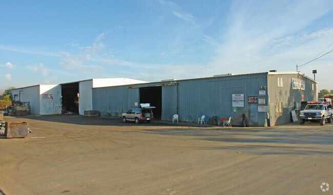
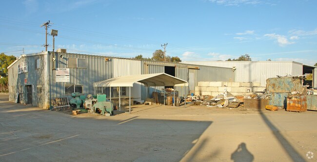
Property Record
2041 Girvan Rd, Redding, CA 96001

Save to a Folder
{{folder.Name}}
{{folder.ListingIds.length}} Properties
{{folder.ListingIds.length}} Property
Create a New Folder
Property Detail
2041 Girvan Rd
050-500-009-000
PORTION LOT5
Industrialgeneral
Shasta
C and X Area of minimal flood hazard, usually depicted on FIRMs as above the 500-year flood level.
California
2024
5
2025
12 AC
011100
Other Market Areas
1,890 SF
Redding, CA
NEARBY LISTINGS FOR SALE OR LEASE
DEMOGRAPHICS near 2041 Girvan Rd
1 mile
3 mile
5 mile
2025 Total Population
4,823
18,176
68,365
2030 Population
4,856
18,294
68,488
Pop Growth 2025-2030
+ 0.68%
+ 0.65%
+ 0.18%
Average Age
42
42
41
2025 Total Households
1,810
6,939
26,585
HH Growth 2025-2030
+ 0.61%
+ 0.63%
+ 0.19%
Median Household Inc
$83,787
$79,931
$78,572
Avg Household Size
2.60
2.50
2.50
2025 Avg HH Vehicles
2.00
2.00
2.00
Median Home Value
$349,692
$349,698
$362,405
Median Year Built
1980
1976
1978
Nearby Places
Map Layers
Map Styles
 Street
 Aerial
Layers
 Traffic
 Biking
Places
Listings with unknown addresses are not visible on the map
- Restaurants
- Banks
- Shops
- Fitness
- Groceries
PUBLIC TRANSPORTATION
COMMUTER RAIL
Redding Amtrak (Coast Starlight - Amtrak)
Drive
Walk
Distance
Redding Amtrak (Coast Starlight - Amtrak)
9 min
5.3 mi
AIRPORT
Redding Regional
Drive
Walk
Distance
Redding Regional
12 min
7.9 mi
Freight Ports
Port of Richmond
Drive
Walk
Distance
Port of Richmond
226 min
200.3 mi
Nearby Properties
Address
Land Use
TOTAL SIZE
Lot Size
Zoning
Address
Land Use
TOTAL SIZE
Lot Size
Zoning
151,773 SF
17.64 AC
Address
Land Use
TOTAL SIZE
Lot Size
Zoning
81,800 SF
14.81 AC
Address
Land Use
TOTAL SIZE
Lot Size
Zoning
50,251 SF
4.06 AC
Address
Land Use
TOTAL SIZE
Lot Size
Zoning
344.24 AC
U
Address
Land Use
TOTAL SIZE
Lot Size
Zoning
11.90 AC
Address
Land Use
TOTAL SIZE
Lot Size
Zoning
11.80 AC
Address
Land Use
TOTAL SIZE
Lot Size
Zoning
90,832 SF
12.44 AC
C-2
Address
Land Use
TOTAL SIZE
Lot Size
Zoning
20.19 AC
C-M
Address
Land Use
TOTAL SIZE
Lot Size
Zoning
3.50 AC
M-L
Address
Land Use
TOTAL SIZE
Lot Size
Zoning
12.26 AC
Address
Land Use
TOTAL SIZE
Lot Size
Zoning
56,474 SF
19.20 AC
Address
Land Use
TOTAL SIZE
Lot Size
Zoning
2,903 SF
1.54 AC
Address
Land Use
TOTAL SIZE
Lot Size
Zoning
8.31 AC
Address
Land Use
TOTAL SIZE
Lot Size
Zoning
1,175 SF
3.91 AC
Address
Land Use
TOTAL SIZE
Lot Size
Zoning
12,467 SF
2.97 AC
Address
Land Use
TOTAL SIZE
Lot Size
Zoning
7.56 AC
Address
Land Use
TOTAL SIZE
Lot Size
Zoning
28,920 SF
1.37 AC
Address
Land Use
TOTAL SIZE
Lot Size
Zoning
22,006 SF
2.72 AC
Address
Land Use
TOTAL SIZE
Lot Size
Zoning
9,100 SF
1.01 AC
Address
Land Use
TOTAL SIZE
Lot Size
Zoning
10.04 AC
Address
Land Use
TOTAL SIZE
Lot Size
Zoning
1,820 SF
16.80 AC
Address
Land Use
TOTAL SIZE
Lot Size
Zoning
17.80 AC
Address
Land Use
TOTAL SIZE
Lot Size
Zoning
3,995 SF
1.31 AC
Address
Land Use
TOTAL SIZE
Lot Size
Zoning
1,440 SF
17.13 AC
R-R-T-BA-9
Address
Land Use
TOTAL SIZE
Lot Size
Zoning
72,496 SF
10.19 AC
Address
Land Use
TOTAL SIZE
Lot Size
Zoning
28,668 SF
2.11 AC
C-M-DR
Address
Land Use
TOTAL SIZE
Lot Size
Zoning
2,752 SF
0.99 AC
Address
Land Use
TOTAL SIZE
Lot Size
Zoning
18,720 SF
5.05 AC
Address
Land Use
TOTAL SIZE
Lot Size
Zoning
13.10 AC
C-M-DR
Address
Land Use
TOTAL SIZE
Lot Size
Zoning
14,658 SF
1.31 AC
The World's #1 Commercial Real Estate Marketplace
Connect with us
© 2026 CoStar Group
The information above has been obtained from sources believed reliable. While we do not doubt its accuracy we have not verified it and make no guarantee, warranty or representation about it. It is your responsibility to independently confirm its accuracy and completeness. Any projections, opinions, assumptions, or estimates used are for example only and do not represent the current or future performance of the property. The value of this transaction to you depends on tax and other factors which should be evaluated by your tax, financial, and legal advisors. You and your advisors should conduct a careful, independent investigation of the property to determine to your satisfaction the suitability of the property for your needs.