Property Record
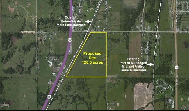
2041 W Smith Ferry Rd, Muskogee, OK 74401

Property Detail
2041 W Smith Ferry Rd
Muskogee, OK
T14N R18E S16 ALL NE & NW LYING EAST OF THE RAILROAD RIGHT OF WAY
28517
MUSKOGEE
Residentialacreage
Oklahoma
B and X Area of moderate flood hazard, usually the area between the limits of the 100-year and 500-year floods.
126.50 AC
2025
Muskogee County
2025
Tulsa
000100
NEARBY LISTINGS FOR SALE OR LEASE
DEMOGRAPHICS near 2041 W Smith Ferry Rd
1 mile
3 mile
5 mile
2025 Total Population
415
6,415
33,220
2030 Population
414
6,418
33,740
Pop Growth 2025-2030
(0.24%)
+ 0.05%
+ 1.57%
Average Age
40
39
39
2025 Total Households
166
2,478
13,377
HH Growth 2025-2030
0.00%
+ 0.20%
+ 1.64%
Median Household Inc
$52,333
$62,763
$50,965
Avg Household Size
2.50
2.60
2.40
2025 Avg HH Vehicles
2.00
2.00
2.00
Median Home Value
$147,058
$173,300
$136,994
Median Year Built
1976
1978
1971
Nearby Places
Map Layers
Map Styles
 Street
 Aerial
Layers
 Traffic
 Biking
Places
Listings with unknown addresses are not visible on the map
- Restaurants
- Banks
- Shops
- Fitness
- Groceries
SALE & LEASE HISTORY
LISTING DATE
SALE/LEASE

Jul 19, 2018
For Sale
Aug 10, 2018
For Lease
Apr 16, 2020
For Lease
Nearby Properties
Address
Land Use
TOTAL SIZE
Lot Size
Zoning
Address
Land Use
TOTAL SIZE
Lot Size
Zoning
35,708 SF
77.67 AC
Address
Land Use
TOTAL SIZE
Lot Size
Zoning
2,000 SF
9.08 AC
Address
Land Use
TOTAL SIZE
Lot Size
Zoning
5,040 SF
8.40 AC
Address
Land Use
TOTAL SIZE
Lot Size
Zoning
4,725 SF
8.51 AC
Address
Land Use
TOTAL SIZE
Lot Size
Zoning
12,000 SF
6.09 AC
B
Address
Land Use
TOTAL SIZE
Lot Size
Zoning
576 SF
21.60 AC
Address
Land Use
TOTAL SIZE
Lot Size
Zoning
11,200 SF
116.16 AC
Address
Land Use
TOTAL SIZE
Lot Size
Zoning
1,984 SF
3.06 AC
D
Address
Land Use
TOTAL SIZE
Lot Size
Zoning
2,972 SF
9 AC
Address
Land Use
TOTAL SIZE
Lot Size
Zoning
38,700 SF
40 AC
Address
Land Use
TOTAL SIZE
Lot Size
Zoning
9,600 SF
1.23 AC
Address
Land Use
TOTAL SIZE
Lot Size
Zoning
42,246 SF
184.05 AC
Address
Land Use
TOTAL SIZE
Lot Size
Zoning
2,350 SF
4.30 AC
Address
Land Use
TOTAL SIZE
Lot Size
Zoning
52.27 AC
Address
Land Use
TOTAL SIZE
Lot Size
Zoning
9,900 SF
0.49 AC
Address
Land Use
TOTAL SIZE
Lot Size
Zoning
4,275 SF
1.60 AC
Address
Land Use
TOTAL SIZE
Lot Size
Zoning
2,732 SF
464.31 AC
Address
Land Use
TOTAL SIZE
Lot Size
Zoning
8,721 SF
4.86 AC
Address
Land Use
TOTAL SIZE
Lot Size
Zoning
100,730 SF
30.36 AC
Address
Land Use
TOTAL SIZE
Lot Size
Zoning
2,625 SF
5 AC
Address
Land Use
TOTAL SIZE
Lot Size
Zoning
8,648 SF
2.60 AC
Address
Land Use
TOTAL SIZE
Lot Size
Zoning
2,240 SF
48.35 AC
Address
Land Use
TOTAL SIZE
Lot Size
Zoning
1,816 SF
17 AC
Address
Land Use
TOTAL SIZE
Lot Size
Zoning
1,826 SF
0.35 AC
Address
Land Use
TOTAL SIZE
Lot Size
Zoning
1,872 SF
0.45 AC
Address
Land Use
TOTAL SIZE
Lot Size
Zoning
6,960 SF
7.50 AC
Address
Land Use
TOTAL SIZE
Lot Size
Zoning
1,602 SF
0.33 AC
Address
Land Use
TOTAL SIZE
Lot Size
Zoning
4,142 SF
15 AC
Address
Land Use
TOTAL SIZE
Lot Size
Zoning
4,252 SF
3.96 AC
The World's #1 Commercial Real Estate Marketplace
Connect with us
© 2026 CoStar Group
The information above has been obtained from sources believed reliable. While we do not doubt its accuracy we have not verified it and make no guarantee, warranty or representation about it. It is your responsibility to independently confirm its accuracy and completeness. Any projections, opinions, assumptions, or estimates used are for example only and do not represent the current or future performance of the property. The value of this transaction to you depends on tax and other factors which should be evaluated by your tax, financial, and legal advisors. You and your advisors should conduct a careful, independent investigation of the property to determine to your satisfaction the suitability of the property for your needs.