Property Record
20410 Leitersburg Pike, Hagerstown, MD 21742


NEARBY LISTINGS FOR SALE OR LEASE
-
-
View all Hagerstown listings for sale on LoopNet.com
Property Detail
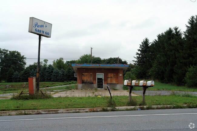
20410 Leitersburg Pike
09-003703
.64 AC 20410 LEITERSBURG PIKE N/S MD 60
Commercialnec
Washington
X
Maryland
24043C0141D
0.64 AC
2024
Washington County
2025
Washington, DC
010200
Hagerstown-Martinsburg, MD-WV
320 SF
DEMOGRAPHICS near 20410 Leitersburg Pike
1 Mile
3 Mile
5 Mile
2024 Total Population
462
10,640
66,424
2029 Population
466
10,750
67,142
Pop Growth 2024-2029
+ 0.87%
+ 1.03%
+ 1.08%
Average Age
42
42
40
2024 Total Households
168
4,060
26,448
HH Growth 2024-2029
+ 0.60%
+ 1.21%
+ 1.15%
Median Household Inc
$81,617
$79,405
$57,177
Avg Household Size
2.70
2.60
2.40
2024 Avg HH Vehicles
2.00
2.00
2.00
Median Home Value
$317,187
$321,120
$234,939
Median Year Built
1985
1987
1971
Nearby Places
Map Layers
Map Styles
 Street
 Aerial
- Restaurants
- Banks
- Shops
- Fitness
- Groceries
PUBLIC TRANSPORTATION
AIRPORT
Hagerstown Regional/Richard A Henson Field
DRIVE
WALK
Distance
Hagerstown Regional/Richard A Henson Field
10 min
5.4 mi
Nearby Properties
Address
Land Use
TOTAL SIZE
Lot Size
Zoning
Address
Land Use
TOTAL SIZE
Lot Size
Zoning
216 SF
52.93 AC
RH
Address
Land Use
TOTAL SIZE
Lot Size
Zoning
71,928 SF
24.77 AC
RMOD
Address
Land Use
TOTAL SIZE
Lot Size
Zoning
23,086 SF
19.36 AC
CR
Address
Land Use
TOTAL SIZE
Lot Size
Zoning
3,159 SF
14.99 AC
CR
Address
Land Use
TOTAL SIZE
Lot Size
Zoning
78,042 SF
11 AC
RB-E
Address
Land Use
TOTAL SIZE
Lot Size
Zoning
1,152 SF
27.83 AC
U
Address
Land Use
TOTAL SIZE
Lot Size
Zoning
7,273 SF
146.87 AC
AR
Address
Land Use
TOTAL SIZE
Lot Size
Zoning
139,403 SF
15.06 AC
CR
Address
Land Use
TOTAL SIZE
Lot Size
Zoning
287,625 SF
19.69 AC
IG
Address
Land Use
TOTAL SIZE
Lot Size
Zoning
20,312 SF
17.59 AC
U
Address
Land Use
TOTAL SIZE
Lot Size
Zoning
47,923 SF
10.25 AC
RS
Address
Land Use
TOTAL SIZE
Lot Size
Zoning
35,460 SF
8.32 AC
RT PU
Address
Land Use
TOTAL SIZE
Lot Size
Zoning
35,424 SF
3 AC
CG
Address
Land Use
TOTAL SIZE
Lot Size
Zoning
40,788 SF
9.69 AC
RMOD
Address
Land Use
TOTAL SIZE
Lot Size
Zoning
6.42 AC
RS
Address
Land Use
TOTAL SIZE
Lot Size
Zoning
16,660 SF
3.08 AC
CG
Address
Land Use
TOTAL SIZE
Lot Size
Zoning
62,480 SF
2.55 AC
BL
Address
Land Use
TOTAL SIZE
Lot Size
Zoning
6,134 SF
2.59 AC
CR
Address
Land Use
TOTAL SIZE
Lot Size
Zoning
16,337 SF
1.10 AC
PB
Address
Land Use
TOTAL SIZE
Lot Size
Zoning
28,578 SF
2.07 AC
BL
Address
Land Use
TOTAL SIZE
Lot Size
Zoning
13,077 SF
1.24 AC
BL
Address
Land Use
TOTAL SIZE
Lot Size
Zoning
9,621 SF
2.94 AC
BL
Address
Land Use
TOTAL SIZE
Lot Size
Zoning
20,691 SF
5.71 AC
RS
Address
Land Use
TOTAL SIZE
Lot Size
Zoning
5,813 SF
4 AC
RS
Address
Land Use
TOTAL SIZE
Lot Size
Zoning
10,500 SF
7.48 AC
BL
Address
Land Use
TOTAL SIZE
Lot Size
Zoning
5,564 SF
10.64 AC
RV
Address
Land Use
TOTAL SIZE
Lot Size
Zoning
3,640 SF
7.97 AC
BL
Address
Land Use
TOTAL SIZE
Lot Size
Zoning
22,470 SF
3.44 AC
BG
Address
Land Use
TOTAL SIZE
Lot Size
Zoning
7,683 SF
10.19 AC
BL
Address
Land Use
TOTAL SIZE
Lot Size
Zoning
5,400 SF
7.27 AC
U
The World's #1 Commercial Real Estate Marketplace
Connect with us
© 2025 CoStar Group
The information above has been obtained from sources believed reliable. While we do not doubt its accuracy we have not verified it and make no guarantee, warranty or representation about it. It is your responsibility to independently confirm its accuracy and completeness. Any projections, opinions, assumptions, or estimates used are for example only and do not represent the current or future performance of the property. The value of this transaction to you depends on tax and other factors which should be evaluated by your tax, financial, and legal advisors. You and your advisors should conduct a careful, independent investigation of the property to determine to your satisfaction the suitability of the property for your needs.