No Photo
Property Record
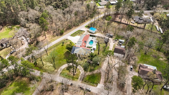
2042 Teal Dr, Spring, TX 77386


NEARBY LISTINGS FOR SALE OR LEASE
-
-
View all Spring listings for sale on LoopNet.com
Property Detail
2042 Teal Dr
Houston-The Woodlands-Sugar Land, TX
Spring Hills 05
8990-05-04200
Montgomery
Sfr
Texas
AE
0.82 AC
48339C0685G
Porter Heights/Woodbranch
4,775 SF
Houston
DEMOGRAPHICS near 2042 Teal Dr
1 Mile
3 Mile
5 Mile
2024 Total Population
8,830
85,627
173,662
2029 Population
10,513
100,137
197,900
Pop Growth 2024-2029
+ 19.06%
+ 16.95%
+ 13.96%
Average Age
35
35
37
2024 Total Households
2,870
28,980
62,058
HH Growth 2024-2029
+ 19.16%
+ 16.87%
+ 14.29%
Median Household Inc
$74,685
$104,016
$97,296
Avg Household Size
3.00
2.90
2.80
2024 Avg HH Vehicles
2.00
2.00
2.00
Median Home Value
$224,294
$274,033
$265,993
Median Year Built
1996
2005
2004
Nearby Places
Map Layers
Map Styles
 Street
 Aerial
- Restaurants
- Banks
- Shops
- Fitness
- Groceries
PUBLIC TRANSPORTATION
AIRPORT
George Bush Intcntl/Houston
DRIVE
WALK
Distance
George Bush Intcntl/Houston
26 min
19.2 mi
William P Hobby
DRIVE
WALK
Distance
William P Hobby
60 min
41.2 mi
Freight Ports
Port of Houston
DRIVE
WALK
Distance
Port of Houston
49 min
35.0 mi
SALE & LEASE HISTORY
LISTING DATE
SALE/LEASE

Mar 19, 2025
For Sale
Jun 02, 2025
For Sale
Nearby Properties
Address
Land Use
TOTAL SIZE
Lot Size
Zoning
Address
Land Use
TOTAL SIZE
Lot Size
Zoning
6,576,138 SF
186.74 AC
Address
Land Use
TOTAL SIZE
Lot Size
Zoning
1,186,001 SF
13.27 AC
Address
Land Use
TOTAL SIZE
Lot Size
Zoning
1,004,830 SF
7.83 AC
Address
Land Use
TOTAL SIZE
Lot Size
Zoning
974,064 SF
11.79 AC
Address
Land Use
TOTAL SIZE
Lot Size
Zoning
802,274 SF
2.68 AC
Address
Land Use
TOTAL SIZE
Lot Size
Zoning
354,981 SF
72.09 AC
Address
Land Use
TOTAL SIZE
Lot Size
Zoning
970,101 SF
48.05 AC
Address
Land Use
TOTAL SIZE
Lot Size
Zoning
457,883 SF
3.74 AC
Address
Land Use
TOTAL SIZE
Lot Size
Zoning
296,094 SF
10.19 AC
Address
Land Use
TOTAL SIZE
Lot Size
Zoning
532,751 SF
6.43 AC
Address
Land Use
TOTAL SIZE
Lot Size
Zoning
314,169 SF
3.09 AC
Address
Land Use
TOTAL SIZE
Lot Size
Zoning
388,855 SF
19.86 AC
6
Address
Land Use
TOTAL SIZE
Lot Size
Zoning
373,310 SF
2.47 AC
Address
Land Use
TOTAL SIZE
Lot Size
Zoning
327,690 SF
14.50 AC
Address
Land Use
TOTAL SIZE
Lot Size
Zoning
141,454 SF
21.13 AC
Address
Land Use
TOTAL SIZE
Lot Size
Zoning
471,015 SF
6.63 AC
Address
Land Use
TOTAL SIZE
Lot Size
Zoning
397,984 SF
6.42 AC
Address
Land Use
TOTAL SIZE
Lot Size
Zoning
333,146 SF
14.81 AC
6
Address
Land Use
TOTAL SIZE
Lot Size
Zoning
293,997 SF
12.87 AC
6
Address
Land Use
TOTAL SIZE
Lot Size
Zoning
278,533 SF
14.79 AC
6
Address
Land Use
TOTAL SIZE
Lot Size
Zoning
331,264 SF
12.92 AC
Address
Land Use
TOTAL SIZE
Lot Size
Zoning
321,024 SF
8.73 AC
6
Address
Land Use
TOTAL SIZE
Lot Size
Zoning
281,487 SF
25.29 AC
6
Address
Land Use
TOTAL SIZE
Lot Size
Zoning
446,410 SF
9.31 AC
6
Address
Land Use
TOTAL SIZE
Lot Size
Zoning
224,000 SF
6.51 AC
6
Address
Land Use
TOTAL SIZE
Lot Size
Zoning
214,156 SF
5.34 AC
Address
Land Use
TOTAL SIZE
Lot Size
Zoning
294,925 SF
21.79 AC
Address
Land Use
TOTAL SIZE
Lot Size
Zoning
199,770 SF
10.55 AC
6
Address
Land Use
TOTAL SIZE
Lot Size
Zoning
15,916 SF
12.53 AC
6
Address
Land Use
TOTAL SIZE
Lot Size
Zoning
446,924 SF
3.55 AC
6
The World's #1 Commercial Real Estate Marketplace
Connect with us
© 2025 CoStar Group
The information above has been obtained from sources believed reliable. While we do not doubt its accuracy we have not verified it and make no guarantee, warranty or representation about it. It is your responsibility to independently confirm its accuracy and completeness. Any projections, opinions, assumptions, or estimates used are for example only and do not represent the current or future performance of the property. The value of this transaction to you depends on tax and other factors which should be evaluated by your tax, financial, and legal advisors. You and your advisors should conduct a careful, independent investigation of the property to determine to your satisfaction the suitability of the property for your needs.