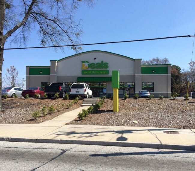
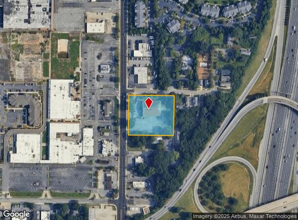
Property Record
2044 Metropolitan Pkwy Sw, Atlanta, GA 30315
NEARBY LISTINGS FOR SALE OR LEASE
Property Detail
2044 Metropolitan Pkwy Sw
Atlanta-Sandy Springs-Roswell, GA
Newton St John
14-0090-0003-082-7
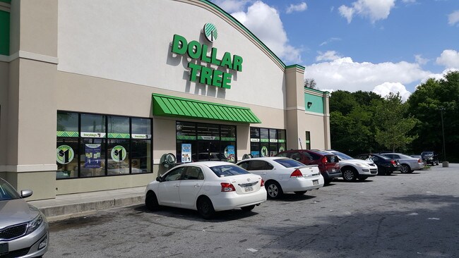
NEW DOLLAR TREE STORE 25CB REMOVE HOF OVERRIDE
Storebuilding
Fulton
X
Georgia
13121C0358F
1-5
2024
1.92 AC
2025
College Park/SW Atl
006702
Atlanta
12,000 SF
DEMOGRAPHICS near 2044 Metropolitan Pkwy Sw
1 Mile
3 Mile
5 Mile
2024 Total Population
8,264
98,832
245,771
2029 Population
8,609
103,521
256,521
Pop Growth 2024-2029
+ 4.17%
+ 4.74%
+ 4.37%
Average Age
39
37
37
2024 Total Households
3,549
40,333
102,762
HH Growth 2024-2029
+ 4.37%
+ 4.86%
+ 4.67%
Median Household Inc
$35,714
$42,239
$53,128
Avg Household Size
2.30
2.30
2.10
2024 Avg HH Vehicles
1.00
1.00
1.00
Median Home Value
$206,535
$245,614
$295,754
Median Year Built
1961
1967
1972
Nearby Places
Map Layers
Map Styles
 Street
 Aerial
- Restaurants
- Banks
- Shops
- Fitness
- Groceries
PUBLIC TRANSPORTATION
COMMUTER RAIL
DRIVE
WALK
Distance
15 min
8.9 mi
AIRPORT
Hartsfield - Jackson Atlanta International
DRIVE
WALK
Distance
Hartsfield - Jackson Atlanta International
12 min
5.7 mi
SALE & LEASE HISTORY
LISTING DATE
SALE/LEASE

May 23, 2019
For Sale
Nearby Properties
Address
Land Use
TOTAL SIZE
Lot Size
Zoning
Address
Land Use
TOTAL SIZE
Lot Size
Zoning
11.74 AC
I1
Address
Land Use
TOTAL SIZE
Lot Size
Zoning
7 AC
C3
Address
Land Use
TOTAL SIZE
Lot Size
Zoning
498,515 SF
3.41 AC
C1
Address
Land Use
TOTAL SIZE
Lot Size
Zoning
595,658 SF
4.09 AC
I1
Address
Land Use
TOTAL SIZE
Lot Size
Zoning
54 AC
I2
Address
Land Use
TOTAL SIZE
Lot Size
Zoning
469,344 SF
3.62 AC
C3
Address
Land Use
TOTAL SIZE
Lot Size
Zoning
436,143 SF
2.90 AC
I1
Address
Land Use
TOTAL SIZE
Lot Size
Zoning
330,125 SF
7.16 AC
I1
Address
Land Use
TOTAL SIZE
Lot Size
Zoning
541,508 SF
110.88 AC
I1
Address
Land Use
TOTAL SIZE
Lot Size
Zoning
386,354 SF
10.03 AC
CR
Address
Land Use
TOTAL SIZE
Lot Size
Zoning
1,128,762 SF
10.39 AC
I2
Address
Land Use
TOTAL SIZE
Lot Size
Zoning
857,294 SF
101.10 AC
I1
Address
Land Use
TOTAL SIZE
Lot Size
Zoning
293,935 SF
8.47 AC
I2
Address
Land Use
TOTAL SIZE
Lot Size
Zoning
318,300 SF
4.60 AC
I1
Address
Land Use
TOTAL SIZE
Lot Size
Zoning
382,918 SF
13.04 AC
CR
Address
Land Use
TOTAL SIZE
Lot Size
Zoning
425,270 SF
201.84 AC
I1
Address
Land Use
TOTAL SIZE
Lot Size
Zoning
396,330 SF
7.02 AC
RG3
Address
Land Use
TOTAL SIZE
Lot Size
Zoning
1,170,962 SF
38.32 AC
C3
Address
Land Use
TOTAL SIZE
Lot Size
Zoning
313,734 SF
22.60 AC
R5
Address
Land Use
TOTAL SIZE
Lot Size
Zoning
563,256 SF
22.69 AC
I1
Address
Land Use
TOTAL SIZE
Lot Size
Zoning
7.65 AC
R5
Address
Land Use
TOTAL SIZE
Lot Size
Zoning
4.25 AC
R3
Address
Land Use
TOTAL SIZE
Lot Size
Zoning
164,664 SF
4.93 AC
I1
Address
Land Use
TOTAL SIZE
Lot Size
Zoning
689,523 SF
34.32 AC
I1
Address
Land Use
TOTAL SIZE
Lot Size
Zoning
1,352,250 SF
3.18 AC
C2
Address
Land Use
TOTAL SIZE
Lot Size
Zoning
427,450 SF
3 AC
C3
Address
Land Use
TOTAL SIZE
Lot Size
Zoning
35.10 AC
R1
Address
Land Use
TOTAL SIZE
Lot Size
Zoning
1,680 SF
2.45 AC
I2
Address
Land Use
TOTAL SIZE
Lot Size
Zoning
193,760 SF
14.46 AC
CR
Address
Land Use
TOTAL SIZE
Lot Size
Zoning
12 AC
R4
The World's #1 Commercial Real Estate Marketplace
Connect with us
© 2025 CoStar Group
The information above has been obtained from sources believed reliable. While we do not doubt its accuracy we have not verified it and make no guarantee, warranty or representation about it. It is your responsibility to independently confirm its accuracy and completeness. Any projections, opinions, assumptions, or estimates used are for example only and do not represent the current or future performance of the property. The value of this transaction to you depends on tax and other factors which should be evaluated by your tax, financial, and legal advisors. You and your advisors should conduct a careful, independent investigation of the property to determine to your satisfaction the suitability of the property for your needs.