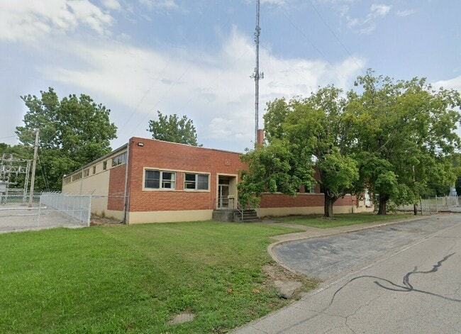
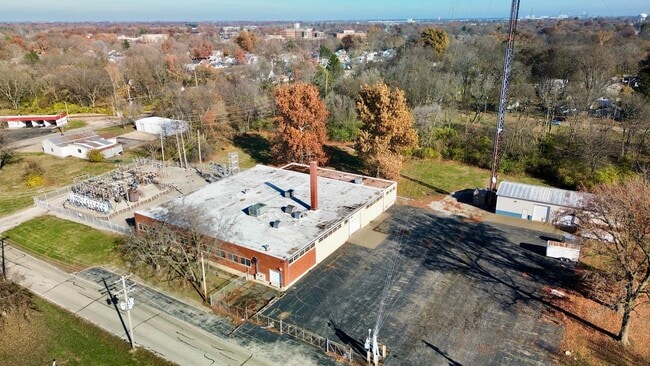
Property Record
2022 N Walnut Grove Ave, Decatur, IL 62526

Current Lease Availabilities
NEARBY LISTINGS FOR SALE OR LEASE
Property Detail
2022 N Walnut Grove Ave
Decatur, IL
H A Woods Walnut Grove Add
04-12-03-354-003
H A WOODS WALNUT GROVE ADD OF O L S250 & 66 E & ADJ FORMER ICRR ROW BLK 1 97BK2707/720 IRREG 83BK247
Officebuilding
Macon
X
Illinois
17115C0301E
1.52 AC
2024
Springfield/Decatur
2024
Other Market Areas
002001
DEMOGRAPHICS near 2022 N Walnut Grove Ave
1 Mile
3 Mile
5 Mile
2024 Total Population
10,619
50,659
73,842
2029 Population
10,612
50,344
72,839
Pop Growth 2024-2029
(0.07%)
(0.62%)
(1.36%)
Average Age
40
40
41
2024 Total Households
4,741
21,965
32,155
HH Growth 2024-2029
(0.30%)
(0.68%)
(1.44%)
Median Household Inc
$33,123
$41,838
$48,841
Avg Household Size
2.10
2.10
2.10
2024 Avg HH Vehicles
1.00
1.00
2.00
Median Home Value
$56,642
$79,441
$94,363
Median Year Built
1953
1957
1961
Nearby Places
Map Layers
Map Styles
 Street
 Aerial
- Restaurants
- Banks
- Shops
- Fitness
- Groceries
Nearby Properties
Address
Land Use
TOTAL SIZE
Lot Size
Zoning
Address
Land Use
TOTAL SIZE
Lot Size
Zoning
1.03 AC
MUNICIPAL
Address
Land Use
TOTAL SIZE
Lot Size
Zoning
207,420 SF
12.41 AC
MUNICIPAL
Address
Land Use
TOTAL SIZE
Lot Size
Zoning
1.40 AC
MUNICIPAL
Address
Land Use
TOTAL SIZE
Lot Size
Zoning
6.60 AC
MUNICIPAL
Address
Land Use
TOTAL SIZE
Lot Size
Zoning
1,604 SF
12.80 AC
MUNICIPAL
Address
Land Use
TOTAL SIZE
Lot Size
Zoning
3.88 AC
MUNICIPAL
Address
Land Use
TOTAL SIZE
Lot Size
Zoning
13.92 AC
MUNICIPAL
Address
Land Use
TOTAL SIZE
Lot Size
Zoning
12.24 AC
MUNICIPAL
Address
Land Use
TOTAL SIZE
Lot Size
Zoning
6.68 AC
MUNICIPAL
Address
Land Use
TOTAL SIZE
Lot Size
Zoning
18.50 AC
MUNICIPAL
Address
Land Use
TOTAL SIZE
Lot Size
Zoning
6.89 AC
MUNICIPAL
Address
Land Use
TOTAL SIZE
Lot Size
Zoning
19.95 AC
MUNICIPAL
Address
Land Use
TOTAL SIZE
Lot Size
Zoning
7.82 AC
MUNICIPAL
Address
Land Use
TOTAL SIZE
Lot Size
Zoning
3.35 AC
MUNICIPAL
Address
Land Use
TOTAL SIZE
Lot Size
Zoning
14.66 AC
MUNICIPAL
Address
Land Use
TOTAL SIZE
Lot Size
Zoning
7.03 AC
MUNICIPAL
Address
Land Use
TOTAL SIZE
Lot Size
Zoning
1.10 AC
MUNICIPAL
Address
Land Use
TOTAL SIZE
Lot Size
Zoning
78.13 AC
MUNICIPAL
Address
Land Use
TOTAL SIZE
Lot Size
Zoning
4.82 AC
MUNICIPAL
Address
Land Use
TOTAL SIZE
Lot Size
Zoning
6.35 AC
MUNICIPAL
Address
Land Use
TOTAL SIZE
Lot Size
Zoning
3.93 AC
MUNICIPAL
Address
Land Use
TOTAL SIZE
Lot Size
Zoning
14.33 AC
MUNICIPAL
Address
Land Use
TOTAL SIZE
Lot Size
Zoning
54.49 AC
MUNICIPAL
Address
Land Use
TOTAL SIZE
Lot Size
Zoning
4.30 AC
MUNICIPAL
Address
Land Use
TOTAL SIZE
Lot Size
Zoning
9.53 AC
MUNICIPAL
Address
Land Use
TOTAL SIZE
Lot Size
Zoning
3.50 AC
MUNICIPAL
Address
Land Use
TOTAL SIZE
Lot Size
Zoning
14.73 AC
MUNICIPAL
Address
Land Use
TOTAL SIZE
Lot Size
Zoning
0.97 AC
MUNICIPAL
Address
Land Use
TOTAL SIZE
Lot Size
Zoning
3.50 AC
MUNICIPAL
The World's #1 Commercial Real Estate Marketplace
Connect with us
© 2026 CoStar Group
The information above has been obtained from sources believed reliable. While we do not doubt its accuracy we have not verified it and make no guarantee, warranty or representation about it. It is your responsibility to independently confirm its accuracy and completeness. Any projections, opinions, assumptions, or estimates used are for example only and do not represent the current or future performance of the property. The value of this transaction to you depends on tax and other factors which should be evaluated by your tax, financial, and legal advisors. You and your advisors should conduct a careful, independent investigation of the property to determine to your satisfaction the suitability of the property for your needs.