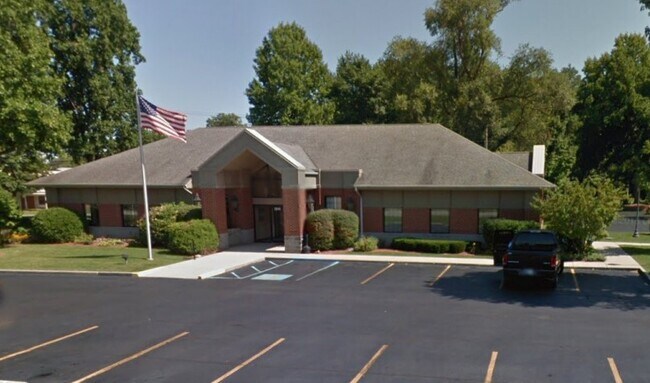
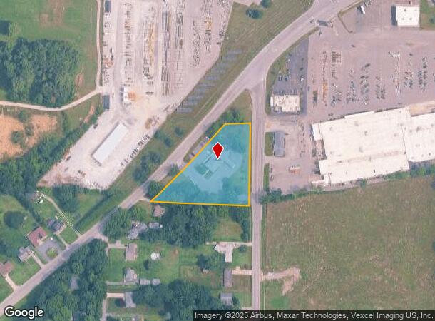
Property Record
2044 W State Road 2, La Porte, IN 46350
NEARBY LISTINGS FOR SALE OR LEASE
Property Detail
2044 W State Road 2
46-10-03-277-003.000-042
04-10-03-277-003 IN SE COR NE 1/4 S3 T36 R3 3 AC
Financialbuilding
La Porte
X
Indiana
18091C0280D
3 AC
2023
South Bend/Elkhart
2024
Other Market Areas
042402
Michigan City-La Porte, IN
4,248 SF
DEMOGRAPHICS near 2044 W State Road 2
1 Mile
3 Mile
5 Mile
2024 Total Population
7,007
25,277
31,752
2029 Population
6,854
24,926
31,316
Pop Growth 2024-2029
(2.18%)
(1.39%)
(1.37%)
Average Age
40
40
41
2024 Total Households
2,907
10,140
12,597
HH Growth 2024-2029
(2.44%)
(1.59%)
(1.56%)
Median Household Inc
$48,601
$54,219
$60,861
Avg Household Size
2.30
2.40
2.40
2024 Avg HH Vehicles
2.00
2.00
2.00
Median Home Value
$132,608
$153,590
$171,006
Median Year Built
1956
1956
1960
Nearby Places
Map Layers
Map Styles
 Street
 Aerial
- Restaurants
- Banks
- Shops
- Fitness
- Groceries
PUBLIC TRANSPORTATION
AIRPORT
South Bend International
DRIVE
WALK
Distance
South Bend International
50 min
27.2 mi
SALE & LEASE HISTORY
LISTING DATE
SALE/LEASE

Sep 25, 2016
For Lease
Oct 09, 2020
For Lease
Nearby Properties
Address
Land Use
TOTAL SIZE
Lot Size
Zoning
Address
Land Use
TOTAL SIZE
Lot Size
Zoning
222,443 SF
5.25 AC
Address
Land Use
TOTAL SIZE
Lot Size
Zoning
225,592 SF
3.72 AC
Address
Land Use
TOTAL SIZE
Lot Size
Zoning
14,274 SF
10.51 AC
Address
Land Use
TOTAL SIZE
Lot Size
Zoning
482,301 SF
49.97 AC
Address
Land Use
TOTAL SIZE
Lot Size
Zoning
104,166 SF
6 AC
Address
Land Use
TOTAL SIZE
Lot Size
Zoning
294,600 SF
22.86 AC
Address
Land Use
TOTAL SIZE
Lot Size
Zoning
289,954 SF
15.78 AC
Address
Land Use
TOTAL SIZE
Lot Size
Zoning
102,386 SF
4.44 AC
Address
Land Use
TOTAL SIZE
Lot Size
Zoning
53,665 SF
8.02 AC
Address
Land Use
TOTAL SIZE
Lot Size
Zoning
603,796 SF
18.96 AC
Address
Land Use
TOTAL SIZE
Lot Size
Zoning
221,703 SF
16.87 AC
Address
Land Use
TOTAL SIZE
Lot Size
Zoning
78,490 SF
5.71 AC
Address
Land Use
TOTAL SIZE
Lot Size
Zoning
18,620 SF
6.87 AC
Address
Land Use
TOTAL SIZE
Lot Size
Zoning
150,364 SF
14.26 AC
Address
Land Use
TOTAL SIZE
Lot Size
Zoning
44,853 SF
5.14 AC
Address
Land Use
TOTAL SIZE
Lot Size
Zoning
185,774 SF
4.89 AC
Address
Land Use
TOTAL SIZE
Lot Size
Zoning
56,034 SF
3.04 AC
Address
Land Use
TOTAL SIZE
Lot Size
Zoning
194,458 SF
17.50 AC
Address
Land Use
TOTAL SIZE
Lot Size
Zoning
439,731 SF
28.77 AC
Address
Land Use
TOTAL SIZE
Lot Size
Zoning
28,154 SF
2.68 AC
Address
Land Use
TOTAL SIZE
Lot Size
Zoning
19,869 SF
13.19 AC
Address
Land Use
TOTAL SIZE
Lot Size
Zoning
1,800 SF
5.92 AC
Address
Land Use
TOTAL SIZE
Lot Size
Zoning
36,179 SF
6.15 AC
Address
Land Use
TOTAL SIZE
Lot Size
Zoning
339,700 SF
31.96 AC
Address
Land Use
TOTAL SIZE
Lot Size
Zoning
52,830 SF
0.32 AC
Address
Land Use
TOTAL SIZE
Lot Size
Zoning
30,505 SF
1.59 AC
Address
Land Use
TOTAL SIZE
Lot Size
Zoning
84,695 SF
37.29 AC
Address
Land Use
TOTAL SIZE
Lot Size
Zoning
19,230 SF
2.32 AC
Address
Land Use
TOTAL SIZE
Lot Size
Zoning
54,262 SF
6.43 AC
Address
Land Use
TOTAL SIZE
Lot Size
Zoning
120,354 SF
11.46 AC
The World's #1 Commercial Real Estate Marketplace
Connect with us
© 2025 CoStar Group
The information above has been obtained from sources believed reliable. While we do not doubt its accuracy we have not verified it and make no guarantee, warranty or representation about it. It is your responsibility to independently confirm its accuracy and completeness. Any projections, opinions, assumptions, or estimates used are for example only and do not represent the current or future performance of the property. The value of this transaction to you depends on tax and other factors which should be evaluated by your tax, financial, and legal advisors. You and your advisors should conduct a careful, independent investigation of the property to determine to your satisfaction the suitability of the property for your needs.