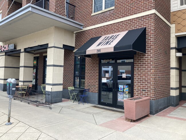
Property Record
2045 Atwood Ave, Madison, WI 53704


Current Lease Availabilities
NEARBY LISTINGS FOR SALE OR LEASE
Property Detail
2045 Atwood Ave
0710-064-4505-3
Kennedy Place Condominium
Commercialnec
KENNEDY PLACE CONDOMINIUM, UNIT 5 & A % INTEREST IN THE COMMON AREA AS DECLARED AND RECORDED IN DANE COUNTY REGISTER OF DEEDS AS DOCUMENT 4627868.
X
Dane
55025C0428G
Wisconsin
2024
1.51 AC
2024
East Madison
001902
Milwaukee/Madison
20,137 SF
Madison, WI
DEMOGRAPHICS near 2045 Atwood Ave
1 Mile
3 Mile
5 Mile
2024 Total Population
17,758
100,300
189,541
2029 Population
18,434
103,272
195,635
Pop Growth 2024-2029
+ 3.81%
+ 2.96%
+ 3.22%
Average Age
39
35
36
2024 Total Households
9,392
46,546
84,726
HH Growth 2024-2029
+ 3.85%
+ 3.22%
+ 3.45%
Median Household Inc
$73,613
$55,295
$61,108
Avg Household Size
1.90
1.90
2.00
2024 Avg HH Vehicles
1.00
1.00
1.00
Median Home Value
$335,804
$280,370
$291,061
Median Year Built
1948
1966
1972
Nearby Places
Map Layers
Map Styles
 Street
 Aerial
- Restaurants
- Banks
- Shops
- Fitness
- Groceries
PUBLIC TRANSPORTATION
AIRPORT
Dane County Regional/Truax Field
DRIVE
WALK
Distance
Dane County Regional/Truax Field
7 min
3.9 mi
Freight Ports
Port Milwaukee
DRIVE
WALK
Distance
Port Milwaukee
92 min
77.7 mi
Nearby Properties
Address
Land Use
TOTAL SIZE
Lot Size
Zoning
Address
Land Use
TOTAL SIZE
Lot Size
Zoning
484,764 SF
1.62 AC
DC
Address
Land Use
TOTAL SIZE
Lot Size
Zoning
395,505 SF
0.99 AC
UMX
Address
Land Use
TOTAL SIZE
Lot Size
Zoning
466,963 SF
761.23 AC
PD
Address
Land Use
TOTAL SIZE
Lot Size
Zoning
509,946 SF
40.17 AC
IL
Address
Land Use
TOTAL SIZE
Lot Size
Zoning
461,454 SF
3.37 AC
CC-T
Address
Land Use
TOTAL SIZE
Lot Size
Zoning
463,006 SF
1.43 AC
UMX
Address
Land Use
TOTAL SIZE
Lot Size
Zoning
208,251 SF
414.76 AC
PD
Address
Land Use
TOTAL SIZE
Lot Size
Zoning
460,603 SF
1.08 AC
PD
Address
Land Use
TOTAL SIZE
Lot Size
Zoning
280,769 SF
0.80 AC
UMX
Address
Land Use
TOTAL SIZE
Lot Size
Zoning
251,632 SF
3.88 AC
TE
Address
Land Use
TOTAL SIZE
Lot Size
Zoning
590,387 SF
1.82 AC
PD
Address
Land Use
TOTAL SIZE
Lot Size
Zoning
421,021 SF
1.30 AC
DC
Address
Land Use
TOTAL SIZE
Lot Size
Zoning
230,268 SF
0.87 AC
UMX
Address
Land Use
TOTAL SIZE
Lot Size
Zoning
289,884 SF
19.36 AC
SR-V2
Address
Land Use
TOTAL SIZE
Lot Size
Zoning
296,708 SF
1 AC
TE
Address
Land Use
TOTAL SIZE
Lot Size
Zoning
207,221 SF
0.60 AC
UMX
Address
Land Use
TOTAL SIZE
Lot Size
Zoning
269,675 SF
2.25 AC
TR-U2
Address
Land Use
TOTAL SIZE
Lot Size
Zoning
211,457 SF
329.05 AC
PD
Address
Land Use
TOTAL SIZE
Lot Size
Zoning
230,504 SF
0.76 AC
PD
Address
Land Use
TOTAL SIZE
Lot Size
Zoning
14,229 SF
0.50 AC
DC
Address
Land Use
TOTAL SIZE
Lot Size
Zoning
254,812 SF
0.64 AC
PD
Address
Land Use
TOTAL SIZE
Lot Size
Zoning
182,821 SF
1.19 AC
PD
Address
Land Use
TOTAL SIZE
Lot Size
Zoning
42,240 SF
0.98 AC
DC
Address
Land Use
TOTAL SIZE
Lot Size
Zoning
13,440 SF
10.98 AC
IL
Address
Land Use
TOTAL SIZE
Lot Size
Zoning
160,531 SF
0.41 AC
UMX
Address
Land Use
TOTAL SIZE
Lot Size
Zoning
216,017 SF
3.35 AC
TE
Address
Land Use
TOTAL SIZE
Lot Size
Zoning
247,984 SF
1 AC
HIS-L
Address
Land Use
TOTAL SIZE
Lot Size
Zoning
197,046 SF
TE
Address
Land Use
TOTAL SIZE
Lot Size
Zoning
234,075 SF
0.80 AC
UMX
Address
Land Use
TOTAL SIZE
Lot Size
Zoning
169,491 SF
0.79 AC
HIS-L
The World's #1 Commercial Real Estate Marketplace
Connect with us
© 2025 CoStar Group
The information above has been obtained from sources believed reliable. While we do not doubt its accuracy we have not verified it and make no guarantee, warranty or representation about it. It is your responsibility to independently confirm its accuracy and completeness. Any projections, opinions, assumptions, or estimates used are for example only and do not represent the current or future performance of the property. The value of this transaction to you depends on tax and other factors which should be evaluated by your tax, financial, and legal advisors. You and your advisors should conduct a careful, independent investigation of the property to determine to your satisfaction the suitability of the property for your needs.