Property Record
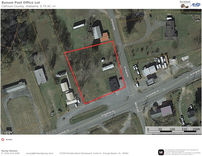
2037 Bynum Blvd, Eastaboga, AL 36260


NEARBY LISTINGS FOR SALE OR LEASE
-
-
View all Eastaboga listings for sale on LoopNet.com
Property Detail
2037 Bynum Blvd
23-07-25-0-001-047.000
SEC 25 TSP 16S RNG 06E A LOT IN NE 1/4 OF NW 1/4 & NW 1/4 OF NE 1/4 OF SEC 25 LOCATED & DESC AS FOLLOWS BEG @ NW INTSC OF HWY
Uspostalservice
Calhoun
A
Alabama
01015C0377E
0.75 AC
2025
Gadsden/Anniston Area
2025
Other Market Areas
001501
Anniston-Oxford-Jacksonville, AL
1,134 SF
DEMOGRAPHICS near 2037 Bynum Blvd
1 Mile
3 Mile
5 Mile
2024 Total Population
1,117
4,860
12,134
2029 Population
1,073
4,706
11,820
Pop Growth 2024-2029
(3.94%)
(3.17%)
(2.59%)
Average Age
40
41
41
2024 Total Households
438
1,912
4,753
HH Growth 2024-2029
(4.34%)
(3.35%)
(2.76%)
Median Household Inc
$53,500
$53,295
$48,022
Avg Household Size
2.50
2.50
2.50
2024 Avg HH Vehicles
2.00
2.00
2.00
Median Home Value
$142,892
$142,382
$127,736
Median Year Built
1981
1982
1980
Nearby Places
Map Layers
Map Styles
 Street
 Aerial
- Restaurants
- Banks
- Shops
- Fitness
- Groceries
PUBLIC TRANSPORTATION
COMMUTER RAIL
Anniston Amtrak Station (Crescent - Amtrak)
DRIVE
WALK
Distance
Anniston Amtrak Station (Crescent - Amtrak)
14 min
8.9 mi
Freight Ports
Port of Mobile
DRIVE
WALK
Distance
Port of Mobile
307 min
273.1 mi
SALE & LEASE HISTORY
LISTING DATE
SALE/LEASE

May 08, 2023
For Sale
Nearby Properties
Address
Land Use
TOTAL SIZE
Lot Size
Zoning
Address
Land Use
TOTAL SIZE
Lot Size
Zoning
242,064 SF
208 AC
Address
Land Use
TOTAL SIZE
Lot Size
Zoning
365,120 SF
Address
Land Use
TOTAL SIZE
Lot Size
Zoning
14,320 SF
Address
Land Use
TOTAL SIZE
Lot Size
Zoning
120,349 SF
35 AC
Address
Land Use
TOTAL SIZE
Lot Size
Zoning
95,046 SF
12 AC
Address
Land Use
TOTAL SIZE
Lot Size
Zoning
60,000 SF
35.21 AC
Address
Land Use
TOTAL SIZE
Lot Size
Zoning
45,686 SF
7.40 AC
Address
Land Use
TOTAL SIZE
Lot Size
Zoning
72,600 SF
5.70 AC
Address
Land Use
TOTAL SIZE
Lot Size
Zoning
Address
Land Use
TOTAL SIZE
Lot Size
Zoning
3,259 SF
2.35 AC
Address
Land Use
TOTAL SIZE
Lot Size
Zoning
12,441 SF
Address
Land Use
TOTAL SIZE
Lot Size
Zoning
Address
Land Use
TOTAL SIZE
Lot Size
Zoning
17,290 SF
3.50 AC
Address
Land Use
TOTAL SIZE
Lot Size
Zoning
7,500 SF
2.30 AC
Address
Land Use
TOTAL SIZE
Lot Size
Zoning
7,569 SF
185.84 AC
Address
Land Use
TOTAL SIZE
Lot Size
Zoning
1,920 SF
10.30 AC
Address
Land Use
TOTAL SIZE
Lot Size
Zoning
1,443 SF
3 AC
Address
Land Use
TOTAL SIZE
Lot Size
Zoning
3,204 SF
3 AC
Address
Land Use
TOTAL SIZE
Lot Size
Zoning
10,534 SF
0.80 AC
Address
Land Use
TOTAL SIZE
Lot Size
Zoning
23,000 SF
1.95 AC
Address
Land Use
TOTAL SIZE
Lot Size
Zoning
11,124 SF
6.80 AC
Address
Land Use
TOTAL SIZE
Lot Size
Zoning
7,200 SF
2.90 AC
Address
Land Use
TOTAL SIZE
Lot Size
Zoning
676 SF
4.43 AC
Address
Land Use
TOTAL SIZE
Lot Size
Zoning
5,036 SF
3.61 AC
Address
Land Use
TOTAL SIZE
Lot Size
Zoning
Address
Land Use
TOTAL SIZE
Lot Size
Zoning
10,640 SF
2.13 AC
Address
Land Use
TOTAL SIZE
Lot Size
Zoning
11,695 SF
11.80 AC
Address
Land Use
TOTAL SIZE
Lot Size
Zoning
7.90 AC
Address
Land Use
TOTAL SIZE
Lot Size
Zoning
4,500 SF
1.25 AC
Address
Land Use
TOTAL SIZE
Lot Size
Zoning
7,200 SF
14.30 AC
The World's #1 Commercial Real Estate Marketplace
Connect with us
© 2025 CoStar Group
The information above has been obtained from sources believed reliable. While we do not doubt its accuracy we have not verified it and make no guarantee, warranty or representation about it. It is your responsibility to independently confirm its accuracy and completeness. Any projections, opinions, assumptions, or estimates used are for example only and do not represent the current or future performance of the property. The value of this transaction to you depends on tax and other factors which should be evaluated by your tax, financial, and legal advisors. You and your advisors should conduct a careful, independent investigation of the property to determine to your satisfaction the suitability of the property for your needs.