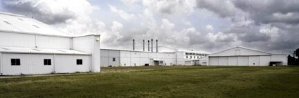
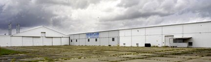
Property Record
2045 Les Mauldin Dr, Brownsville, TX 78521


NEARBY LISTINGS FOR SALE OR LEASE
Property Detail
2045 Les Mauldin Dr
Brownsville-Harlingen, TX
Airport Industrial Park Subd I
012660-0010-001000
AIRPORT INDUSTRIAL PARK SUBD I LOTS 1 TO 13 BLK 1
Taxexempt
Cameron
X
Texas
48061C0595F
1-13
0
5.99 AC
2025
Greater Brownsville
980100
Brownsville/Harlingen
54,360 SF
DEMOGRAPHICS near 2045 Les Mauldin Dr
1 Mile
3 Mile
5 Mile
2024 Total Population
8,459
78,586
138,689
2029 Population
8,780
80,915
142,484
Pop Growth 2024-2029
+ 3.79%
+ 2.96%
+ 2.74%
Average Age
36
35
35
2024 Total Households
2,645
22,846
42,566
HH Growth 2024-2029
+ 3.97%
+ 3.04%
+ 2.73%
Median Household Inc
$35,757
$36,733
$38,181
Avg Household Size
3.20
3.30
3.20
2024 Avg HH Vehicles
2.00
2.00
2.00
Median Home Value
$66,711
$70,730
$82,541
Median Year Built
1989
1992
1990
Nearby Places
Map Layers
Map Styles
 Street
 Aerial
- Restaurants
- Banks
- Shops
- Fitness
- Groceries
PUBLIC TRANSPORTATION
AIRPORT
Brownsville/South Padre Island International
DRIVE
WALK
Distance
Brownsville/South Padre Island International
1 min
0.2 mi
Valley International
DRIVE
WALK
Distance
Valley International
51 min
31.0 mi
Nearby Properties
Address
Land Use
TOTAL SIZE
Lot Size
Zoning
Address
Land Use
TOTAL SIZE
Lot Size
Zoning
328,021 SF
70.19 AC
SD6
Address
Land Use
TOTAL SIZE
Lot Size
Zoning
248,857 SF
37.16 AC
Address
Land Use
TOTAL SIZE
Lot Size
Zoning
167,737 SF
29.87 AC
Address
Land Use
TOTAL SIZE
Lot Size
Zoning
286,243 SF
19.21 AC
C
Address
Land Use
TOTAL SIZE
Lot Size
Zoning
145,240 SF
17.49 AC
Address
Land Use
TOTAL SIZE
Lot Size
Zoning
132,197 SF
10.70 AC
Address
Land Use
TOTAL SIZE
Lot Size
Zoning
213,521 SF
38.75 AC
Address
Land Use
TOTAL SIZE
Lot Size
Zoning
115,463 SF
22.09 AC
Address
Land Use
TOTAL SIZE
Lot Size
Zoning
88,591 SF
22 AC
SD6
Address
Land Use
TOTAL SIZE
Lot Size
Zoning
107,815 SF
10 AC
Address
Land Use
TOTAL SIZE
Lot Size
Zoning
87,909 SF
12 AC
Address
Land Use
TOTAL SIZE
Lot Size
Zoning
392,622 SF
55 AC
I
Address
Land Use
TOTAL SIZE
Lot Size
Zoning
81,191 SF
19.56 AC
Address
Land Use
TOTAL SIZE
Lot Size
Zoning
238,221 SF
27.02 AC
Address
Land Use
TOTAL SIZE
Lot Size
Zoning
88,256 SF
18.16 AC
Address
Land Use
TOTAL SIZE
Lot Size
Zoning
195,810 SF
26.95 AC
Address
Land Use
TOTAL SIZE
Lot Size
Zoning
462.60 AC
Address
Land Use
TOTAL SIZE
Lot Size
Zoning
96,314 SF
6.77 AC
C
Address
Land Use
TOTAL SIZE
Lot Size
Zoning
137,228 SF
18.43 AC
A-U
Address
Land Use
TOTAL SIZE
Lot Size
Zoning
102,316 SF
10.93 AC
Address
Land Use
TOTAL SIZE
Lot Size
Zoning
56,918 SF
2.95 AC
Address
Land Use
TOTAL SIZE
Lot Size
Zoning
85,803 SF
2.75 AC
Address
Land Use
TOTAL SIZE
Lot Size
Zoning
82,098 SF
20.25 AC
Address
Land Use
TOTAL SIZE
Lot Size
Zoning
151,872 SF
Address
Land Use
TOTAL SIZE
Lot Size
Zoning
189,213 SF
10.40 AC
C
Address
Land Use
TOTAL SIZE
Lot Size
Zoning
53,035 SF
2 AC
Address
Land Use
TOTAL SIZE
Lot Size
Zoning
181,695 SF
19.67 AC
Address
Land Use
TOTAL SIZE
Lot Size
Zoning
75,196 SF
15.86 AC
Address
Land Use
TOTAL SIZE
Lot Size
Zoning
109,075 SF
10.45 AC
C
Address
Land Use
TOTAL SIZE
Lot Size
Zoning
48,760 SF
7 AC
C
The World's #1 Commercial Real Estate Marketplace
Connect with us
© 2025 CoStar Group
The information above has been obtained from sources believed reliable. While we do not doubt its accuracy we have not verified it and make no guarantee, warranty or representation about it. It is your responsibility to independently confirm its accuracy and completeness. Any projections, opinions, assumptions, or estimates used are for example only and do not represent the current or future performance of the property. The value of this transaction to you depends on tax and other factors which should be evaluated by your tax, financial, and legal advisors. You and your advisors should conduct a careful, independent investigation of the property to determine to your satisfaction the suitability of the property for your needs.