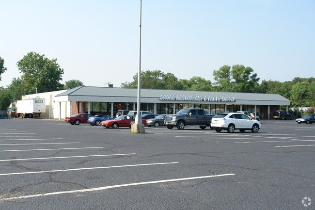
Property Record
2045 Route 88, Brick, NJ 08724

Property Detail
2045 Route 88
Lakewood-New Brunswick, NJ
2.0661AC
07-00902-0000-00002
Ocean
Commercialnec
New Jersey
B2
2
B and X Area of moderate flood hazard, usually the area between the limits of the 100-year and 500-year floods.
2.07 AC
2025
Ocean County
2025
Northern New Jersey
713600
NEARBY LISTINGS FOR SALE OR LEASE
DEMOGRAPHICS near 2045 Route 88
1 mile
3 mile
5 mile
2025 Total Population
9,985
79,913
166,664
2030 Population
10,096
81,176
169,911
Pop Growth 2025-2030
+ 1.11%
+ 1.58%
+ 1.95%
Average Age
42
42
42
2025 Total Households
3,904
31,104
63,693
HH Growth 2025-2030
+ 0.41%
+ 0.93%
+ 1.60%
Median Household Inc
$97,474
$102,656
$101,811
Avg Household Size
2.50
2.50
2.50
2025 Avg HH Vehicles
2.00
2.00
2.00
Median Home Value
$423,805
$434,177
$469,354
Median Year Built
1972
1973
1975
Nearby Places
Map Layers
Map Styles
 Street
 Aerial
Transit
 Traffic
 Biking
Places
Listings with unknown addresses are not visible on the map
- Restaurants
- Banks
- Shops
- Fitness
- Groceries
PUBLIC TRANSPORTATION
COMMUTER RAIL
Bay Head (North Jersey Coast Line - NJ Transit Commuter Rail (NJ Transit))
Drive
Walk
Distance
Bay Head (North Jersey Coast Line - NJ Transit Commuter Rail (NJ Transit))
8 min
4.3 mi
Point Pleasant Beach (North Jersey Coast Line - NJ Transit Commuter Rail (NJ Transit))
Drive
Walk
Distance
Point Pleasant Beach (North Jersey Coast Line - NJ Transit Commuter Rail (NJ Transit))
8 min
4.4 mi
Freight Ports
New York Container Terminal
Drive
Walk
Distance
New York Container Terminal
67 min
51.4 mi
SALE & LEASE HISTORY
LISTING DATE
SALE/LEASE

Mar 24, 2020
For Sale
Jun 02, 2023
For Lease
Feb 11, 2025
For Lease
Nearby Properties
Address
Land Use
TOTAL SIZE
Lot Size
Zoning
Address
Land Use
TOTAL SIZE
Lot Size
Zoning
45.53 AC
B3
Address
Land Use
TOTAL SIZE
Lot Size
Zoning
22.88 AC
HS
Address
Land Use
TOTAL SIZE
Lot Size
Zoning
117 AC
RR1
Address
Land Use
TOTAL SIZE
Lot Size
Zoning
11,900 SF
30.98 AC
R-1A
Address
Land Use
TOTAL SIZE
Lot Size
Zoning
29.34 AC
B4
Address
Land Use
TOTAL SIZE
Lot Size
Zoning
25.22 AC
B3
Address
Land Use
TOTAL SIZE
Lot Size
Zoning
49.57 AC
RR1
Address
Land Use
TOTAL SIZE
Lot Size
Zoning
26.37 AC
R75
Address
Land Use
TOTAL SIZE
Lot Size
Zoning
30 AC
RR1
Address
Land Use
TOTAL SIZE
Lot Size
Zoning
39.84 AC
OPT
Address
Land Use
TOTAL SIZE
Lot Size
Zoning
26.43 AC
B3
Address
Land Use
TOTAL SIZE
Lot Size
Zoning
3,792 SF
7.64 AC
R-1A
Address
Land Use
TOTAL SIZE
Lot Size
Zoning
11.83 AC
B3
Address
Land Use
TOTAL SIZE
Lot Size
Zoning
9,429 SF
9.12 AC
B3
Address
Land Use
TOTAL SIZE
Lot Size
Zoning
63,136 SF
10.31 AC
R-1A
Address
Land Use
TOTAL SIZE
Lot Size
Zoning
47.75 AC
RR2
Address
Land Use
TOTAL SIZE
Lot Size
Zoning
14.38 AC
B3
Address
Land Use
TOTAL SIZE
Lot Size
Zoning
32.80 AC
RM
Address
Land Use
TOTAL SIZE
Lot Size
Zoning
32.50 AC
RM
Address
Land Use
TOTAL SIZE
Lot Size
Zoning
18.39 AC
B3
Address
Land Use
TOTAL SIZE
Lot Size
Zoning
194,670 SF
22 AC
M1
Address
Land Use
TOTAL SIZE
Lot Size
Zoning
10.84 AC
RM
Address
Land Use
TOTAL SIZE
Lot Size
Zoning
5,121 SF
26.15 AC
B3
Address
Land Use
TOTAL SIZE
Lot Size
Zoning
149,402 SF
9.79 AC
M1
Address
Land Use
TOTAL SIZE
Lot Size
Zoning
7.32 AC
RM
Address
Land Use
TOTAL SIZE
Lot Size
Zoning
5.09 AC
HS
Address
Land Use
TOTAL SIZE
Lot Size
Zoning
13.15 AC
B3
Address
Land Use
TOTAL SIZE
Lot Size
Zoning
21.36 AC
RM
Address
Land Use
TOTAL SIZE
Lot Size
Zoning
16.85 AC
B2
Address
Land Use
TOTAL SIZE
Lot Size
Zoning
1,140 SF
14 AC
GC
The World's #1 Commercial Real Estate Marketplace
Connect with us
© 2026 CoStar Group
The information above has been obtained from sources believed reliable. While we do not doubt its accuracy we have not verified it and make no guarantee, warranty or representation about it. It is your responsibility to independently confirm its accuracy and completeness. Any projections, opinions, assumptions, or estimates used are for example only and do not represent the current or future performance of the property. The value of this transaction to you depends on tax and other factors which should be evaluated by your tax, financial, and legal advisors. You and your advisors should conduct a careful, independent investigation of the property to determine to your satisfaction the suitability of the property for your needs.