Property Record
2045 W Highway 7 Ave, Marlow, OK 73055

NEARBY LISTINGS FOR SALE OR LEASE
-
-
View all Marlow listings for lease on LoopNet.com
Property Detail
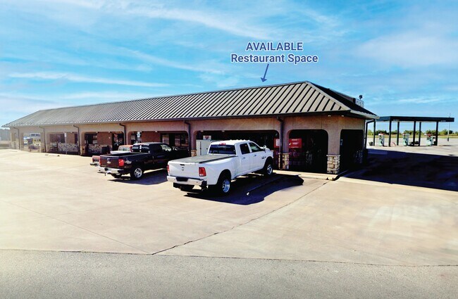
2045 W Highway 7 Ave
3099-31-02N-07W-4-001-00
31-2N-7W TR COM SE/4 N000046W 661.02 S895530W 88.10 TO POB S000046E 264.94 S591202W 419.02 N000107E 151.90 S895714W 213 N0001
Conveniencestore
Stephens
X
Oklahoma
40137C0225F
7w
2024
5 AC
2025
Oklahoma West Area
000901
Other Market Areas
6,250 SF
Duncan, OK
DEMOGRAPHICS near 2045 W Highway 7 Ave
1 Mile
3 Mile
5 Mile
2024 Total Population
238
2,755
12,919
2029 Population
241
2,819
13,373
Pop Growth 2024-2029
+ 1.26%
+ 2.32%
+ 3.51%
Average Age
43
44
44
2024 Total Households
93
1,086
5,331
HH Growth 2024-2029
+ 1.08%
+ 2.21%
+ 3.38%
Median Household Inc
$65,625
$64,953
$61,376
Avg Household Size
2.50
2.50
2.40
2024 Avg HH Vehicles
2.00
2.00
2.00
Median Home Value
$207,500
$183,286
$169,918
Median Year Built
1986
1983
1978
Nearby Places
Map Layers
Map Styles
 Street
 Aerial
- Restaurants
- Banks
- Shops
- Fitness
- Groceries
PUBLIC TRANSPORTATION
AIRPORT
Lawton-Fort Sill Regional
DRIVE
WALK
Distance
Lawton-Fort Sill Regional
39 min
28.3 mi
SALE & LEASE HISTORY
LISTING DATE
SALE/LEASE

Nov 07, 2024
For Lease
Nearby Properties
Address
Land Use
TOTAL SIZE
Lot Size
Zoning
Address
Land Use
TOTAL SIZE
Lot Size
Zoning
154 SF
14 AC
Address
Land Use
TOTAL SIZE
Lot Size
Zoning
160 SF
43.16 AC
Address
Land Use
TOTAL SIZE
Lot Size
Zoning
5,037 SF
13.41 AC
Address
Land Use
TOTAL SIZE
Lot Size
Zoning
2,989 SF
13.49 AC
C2
Address
Land Use
TOTAL SIZE
Lot Size
Zoning
160 SF
6.70 AC
C2
Address
Land Use
TOTAL SIZE
Lot Size
Zoning
532 SF
40.47 AC
C1
Address
Land Use
TOTAL SIZE
Lot Size
Zoning
5,250 SF
4.17 AC
C1
Address
Land Use
TOTAL SIZE
Lot Size
Zoning
10,500 SF
1.91 AC
C2
Address
Land Use
TOTAL SIZE
Lot Size
Zoning
1,200 SF
20 AC
Address
Land Use
TOTAL SIZE
Lot Size
Zoning
11,768 SF
1.38 AC
C2
Address
Land Use
TOTAL SIZE
Lot Size
Zoning
7,380 SF
8.61 AC
R1
Address
Land Use
TOTAL SIZE
Lot Size
Zoning
3,708 SF
3.79 AC
R1
Address
Land Use
TOTAL SIZE
Lot Size
Zoning
18,180 SF
4.59 AC
C1
Address
Land Use
TOTAL SIZE
Lot Size
Zoning
1,750 SF
5 AC
R1
Address
Land Use
TOTAL SIZE
Lot Size
Zoning
3,845 SF
2.37 AC
Address
Land Use
TOTAL SIZE
Lot Size
Zoning
30,000 SF
4.88 AC
C2
Address
Land Use
TOTAL SIZE
Lot Size
Zoning
7,200 SF
14.05 AC
C2
Address
Land Use
TOTAL SIZE
Lot Size
Zoning
138,230 SF
20.48 AC
C1
Address
Land Use
TOTAL SIZE
Lot Size
Zoning
966 SF
4.81 AC
C2
Address
Land Use
TOTAL SIZE
Lot Size
Zoning
2,664 SF
11.89 AC
R1
Address
Land Use
TOTAL SIZE
Lot Size
Zoning
3,985 SF
5 AC
C1
Address
Land Use
TOTAL SIZE
Lot Size
Zoning
1,800 SF
14.65 AC
C2
Address
Land Use
TOTAL SIZE
Lot Size
Zoning
3,600 SF
45.04 AC
Address
Land Use
TOTAL SIZE
Lot Size
Zoning
2,000 SF
9.95 AC
C2
Address
Land Use
TOTAL SIZE
Lot Size
Zoning
3,200 SF
3.28 AC
C2
Address
Land Use
TOTAL SIZE
Lot Size
Zoning
1,960 SF
2.21 AC
R1
Address
Land Use
TOTAL SIZE
Lot Size
Zoning
10,685 SF
2.63 AC
C2
Address
Land Use
TOTAL SIZE
Lot Size
Zoning
6,868 SF
4.14 AC
C1
The World's #1 Commercial Real Estate Marketplace
Connect with us
© 2026 CoStar Group
The information above has been obtained from sources believed reliable. While we do not doubt its accuracy we have not verified it and make no guarantee, warranty or representation about it. It is your responsibility to independently confirm its accuracy and completeness. Any projections, opinions, assumptions, or estimates used are for example only and do not represent the current or future performance of the property. The value of this transaction to you depends on tax and other factors which should be evaluated by your tax, financial, and legal advisors. You and your advisors should conduct a careful, independent investigation of the property to determine to your satisfaction the suitability of the property for your needs.