Property Record
2046 State Rd, Eliot, ME 03903

Save to a Folder
{{folder.Name}}
{{folder.ListingIds.length}} Properties
{{folder.ListingIds.length}} Property
Create a New Folder
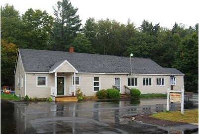
Property Detail
2046 State Rd
Daycare
York
RD
Maine
B and X Area of moderate flood hazard, usually the area between the limits of the 100-year and 500-year floods.
0.78 AC
2025
York County
2025
Portland/South Portland
037000
Portland-South Portland, ME
3,308 SF
ELIO-000079-000012
NEARBY LISTINGS FOR SALE OR LEASE
-
-
View all Eliot listings for sale on LoopNet.com
DEMOGRAPHICS near 2046 State Rd
1 mile
3 mile
5 mile
2025 Total Population
1,206
9,460
42,425
2030 Population
1,208
9,533
43,110
Pop Growth 2025-2030
+ 0.17%
+ 0.77%
+ 1.61%
Average Age
45
45
42
2025 Total Households
480
3,999
18,889
HH Growth 2025-2030
+ 0.21%
+ 0.80%
+ 1.75%
Median Household Inc
$121,283
$124,132
$94,317
Avg Household Size
2.50
2.30
2.20
2025 Avg HH Vehicles
2.00
2.00
2.00
Median Home Value
$616,346
$528,455
$471,130
Median Year Built
1978
1981
1976
Nearby Places
Map Layers
Map Styles
 Street
 Aerial
Layers
 Traffic
 Biking
Places
Listings with unknown addresses are not visible on the map
- Restaurants
- Banks
- Shops
- Fitness
- Groceries
PUBLIC TRANSPORTATION
COMMUTER RAIL
Dover (Downeaster - Amtrak)
Drive
Walk
Distance
Dover (Downeaster - Amtrak)
11 min
5.2 mi
AIRPORT
Portsmouth International at Pease
Drive
Walk
Distance
Portsmouth International at Pease
21 min
10.3 mi
Freight Ports
Portland, ME
Drive
Walk
Distance
Portland, ME
68 min
54.5 mi
Nearby Properties
Address
Land Use
TOTAL SIZE
Lot Size
Zoning
Address
Land Use
TOTAL SIZE
Lot Size
Zoning
98.73 AC
C/I
Address
Land Use
TOTAL SIZE
Lot Size
Zoning
0.67 AC
VD
Address
Land Use
TOTAL SIZE
Lot Size
Zoning
672 SF
50.98 AC
I1 IND
Address
Land Use
TOTAL SIZE
Lot Size
Zoning
4.30 AC
I1 IND
Address
Land Use
TOTAL SIZE
Lot Size
Zoning
3.66 AC
IT
Address
Land Use
TOTAL SIZE
Lot Size
Zoning
71.83 AC
R-40
Address
Land Use
TOTAL SIZE
Lot Size
Zoning
35.86 AC
R-40
Address
Land Use
TOTAL SIZE
Lot Size
Zoning
11 AC
R-20
Address
Land Use
TOTAL SIZE
Lot Size
Zoning
19 AC
RM-SU
Address
Land Use
TOTAL SIZE
Lot Size
Zoning
14.15 AC
R-20
Address
Land Use
TOTAL SIZE
Lot Size
Zoning
3.01 AC
IT
Address
Land Use
TOTAL SIZE
Lot Size
Zoning
1.80 AC
IT
Address
Land Use
TOTAL SIZE
Lot Size
Zoning
3.31 AC
C*
Address
Land Use
TOTAL SIZE
Lot Size
Zoning
18.40 AC
R-40
Address
Land Use
TOTAL SIZE
Lot Size
Zoning
1.81 AC
IT
Address
Land Use
TOTAL SIZE
Lot Size
Zoning
30 AC
SD
Address
Land Use
TOTAL SIZE
Lot Size
Zoning
2.74 AC
IT
Address
Land Use
TOTAL SIZE
Lot Size
Zoning
10,632 SF
16.30 AC
R-40
Address
Land Use
TOTAL SIZE
Lot Size
Zoning
1.65 AC
IT
Address
Land Use
TOTAL SIZE
Lot Size
Zoning
10,509 SF
18.90 AC
R-40
Address
Land Use
TOTAL SIZE
Lot Size
Zoning
5.80 AC
R-40
Address
Land Use
TOTAL SIZE
Lot Size
Zoning
3.06 AC
SD
Address
Land Use
TOTAL SIZE
Lot Size
Zoning
301 AC
RD
Address
Land Use
TOTAL SIZE
Lot Size
Zoning
23,925 SF
2.97 AC
I1 IND
Address
Land Use
TOTAL SIZE
Lot Size
Zoning
3.07 AC
C
Address
Land Use
TOTAL SIZE
Lot Size
Zoning
271 AC
R-40
Address
Land Use
TOTAL SIZE
Lot Size
Zoning
4.74 AC
RD
Address
Land Use
TOTAL SIZE
Lot Size
Zoning
49.31 AC
SD
Address
Land Use
TOTAL SIZE
Lot Size
Zoning
3.45 AC
IT
Address
Land Use
TOTAL SIZE
Lot Size
Zoning
51,200 SF
15.70 AC
C/I
The World's #1 Commercial Real Estate Marketplace
Connect with us
© 2026 CoStar Group
The information above has been obtained from sources believed reliable. While we do not doubt its accuracy we have not verified it and make no guarantee, warranty or representation about it. It is your responsibility to independently confirm its accuracy and completeness. Any projections, opinions, assumptions, or estimates used are for example only and do not represent the current or future performance of the property. The value of this transaction to you depends on tax and other factors which should be evaluated by your tax, financial, and legal advisors. You and your advisors should conduct a careful, independent investigation of the property to determine to your satisfaction the suitability of the property for your needs.